Banda Lake
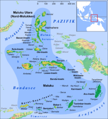
The Banda Sea is a marginal sea of the Pacific Ocean , in the middle of the Indonesian island world.
geography
The Banda Sea extends about 1200 kilometers from west to east, from 122 ° to 132 ° east longitude and about 600 kilometers from north to south, from 2 ° to 8 ° south latitude. It is framed by the Great Sunda Islands in the west, the Bandabogen with the Lesser Sunda Islands in the south and the Moluccas in the north and east. She goes to the north in the Molukka over, in the northeast in the Ceram Sea , to the east in the Arafura Sea , to the south in the Timor Sea , in the southwest in the Savu Sea and to the west in the Flores Sea .
Larger islands on the edges of the Banda Sea are Sulawesi with Buton and Muna in the west, Buru , Seram and Yamdena , Timor , Wetar and Flores in the south. Although the Banda Sea is bordered by thousands of rocky islands and ships have to navigate carefully there, it is almost island-free in its center; Mention should be made of the Banda Islands .
The deep sea basin of the Banda Sea is up to 5800 meters deep. The deepest point, however, lies in the east of the Banda Sea with the Weber Deep (7440 meters).
The Banda Sea is regularly shaken by earthquakes - those of 1938, 2005, 2006 and 2009 should be mentioned.
The Timorese call the calm Banda Sea Tasi Feto , the women's sea, in contrast to the rough Timor Sea, the Tasi Mane , the men's sea .
history
The Banda Sea was hydrologically explored in detail during the Dutch Siboga expedition from 1899–1900 .
Before the First World War , the Dutch KPM offered many ship connections between the islands of the Banda Sea and neighboring areas. The North German Lloyd ran a line from Friedrich-Wilhelm harbor in German New Guinea on Banda and Ambon to Makassar .
Individual evidence
- ↑ Maeve McCusker, Anthony Soares Soares: Islanded Identities: Constructions of Postcolonial Cultural Insularity , p. 170, 2011, ISBN 9042034068
Coordinates: 5 ° S , 127 ° E


