
Madang
| Madang | |||
| State : |
|
||
| Province : |
|
||
| Coordinates : | 5 ° 14 ′ S , 145 ° 48 ′ E | ||
| Residents : | 35,971 (2011) | ||
| Time zone : | AEST (UTC + 10) | ||
|
|||

Madang (German historically: Friedrich-Wilhelms-Hafen or Friedrich-Wilhelmshafen ) is the capital of the Madang province on the north coast of Papua New Guinea . Settlements on the periphery of the city increased the population to 35,971 inhabitants in 2011 (1980 census: 21,335 inhabitants). Madang is the sixth largest city in Papua New Guinea after Port Moresby , Lae , Arawa , Mount Hagen and Popondetta .
geography
Madang is located in the center of the long north coast on Astrolabe Bay . The nearby mountains separate the city from the inland and make it difficult to reach, especially in the rainy season, when landslides make the pass roads impassable.
location
Madang is at the north end of Astrolabe Bay. While access to the sea is free in the east, there are smaller coral islands and reefs in the north. The land is flat for a radius of around six kilometers to the west. The historical foundation took place only in the north-eastern part of the natural harbor, as it was neither affected by mangroves nor marshy river mouths. The main reason given, however, was the fresh air supply coming from the sea, which was of particular importance for the health of the colonists.
history


Friedrich-Wilhelmshafen was discovered by Otto Finsch and Captain Eduard Dallmann . On behalf of the New Guinea Company , an expedition examined the landing point in April 1886 and declared it unsuitable for establishing a plantation. It was not until 1888, after a renewed assessment, that there was consistently good soil conditions that would make it possible to plant coffee.
The station was built in the summer of 1891 and from September 17, 1892 it was the seat of the state administration with the Imperial Government Commissioner. The government building was on the Eickstedt Island to the north . The state administration had previously administered the property from Stephansort, 23 kilometers away . The general director of the New Guinea company remained in Stephansort. When the administrative headquarters were relocated, Papuans accompanied the German administrative officials. These locals named Friedrich-Wilhelmshafen “Madang” after their home island. After the end of German colonial rule, "Madang" became the official place name. From 1896 the economic importance of the Friedrich-Wilhelmshafen plantations was severely restricted in favor of the more important plantations of Stephansort for a few years. Friedrich-Wilhelmshafen was connected to Jomba, Erimahafen and Stephansort by a field railway pulled by oxen. At first there was also a mule track from Stephansort to Friedrich-Wilhelmshafen. However, this had already been given up in 1912 and was only maintained from Stephansort about twelve kilometers to the Marien River.
Friedrich-Wilhelmshafen was expanded between 1893 and 1894. In 1896 the station consisted of 13 houses for Europeans, which were built on two meter high stakes. 10 other buildings were used for administration, as houses for locals, as storage, shed and as a sawmill. A factory for processing the widely used leaves of the atap palm had already been closed at that time. The hospital, which is only accessible to Europeans, was first built on Beliao Island in 1892. In 1897 it was moved to the Schering Island. The former home of Governor Georg Schmiele , which has been free since 1895, was converted into a hospital with eight beds for Europeans and 160 local residents. Since 1892 there has been a local hospital on Kutter Island right in the harbor. During the two kilometers to the north island Siar was one by the Rhenish Missionary Society powered mission .
In the years 1895 and 1896, several German warships took part in surveys in the protected areas . In addition to a number of sailors, a particularly large number of surveyors fell ill - a total of 295 men. Friedrich-Wilhelms-Hafen and Stephansort, among others, could be identified as places of origin of the disease, which were now also referred to as “very unhealthy places”. However, the contemporary visitors to Stephansort had the impression of a relatively healthy climate.
From 1899 the settlement with the previous protected area became part of the German colonial possessions in the Bismarck Archipelago and thus lost its status as the capital of the New Guinea Company. Herbertshöhe on the island of New Pomerania (now New Britain) became the new capital .
Attractions
The modern city of Madang, with its traffic and supermarkets, is considered to be the beating heart of the more unspoilt province of Madang that surrounds it .
Although badly affected by recent changes, Madang is still considered one of the most beautiful cities in the South Pacific and arguably the most beautiful in Papua New Guinea. Lots of green, beautiful parks and a wonderfully situated golf course adorn the place, which extends on a peninsula into the blue-turquoise sea.
Education and Research
The Catholic Divine Word University and a campus of the University of Papua New Guinea are located in Madang . In Yagaum, 20 km outside the city, there is a branch of the Papua New Guinea Institute of Medical Research on the grounds of a Lutheran hospital, where malaria , lymphatic filariasis , and other diseases of the local population are researched and students are trained.
tourism
Madang has several hotels and guest houses. The city is connected by several daily flights with the capital Port Moresby and other cities in the country (e.g. Wewak ). Local attractions include trips to nearby smaller islands and diving trips. Madang is also the landing point for cruise ships and the starting point for tourist excursions in the highlands of Papua New Guinea with destination Goroka or Mount-Hagen .
photos

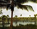
Madang Lagoon
German colonial lagoon (before 1910)

Madanger Airport
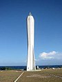
Coastwatcher Memorial, Kalibobo

.jpg&filetimestamp=20100404144935&)
.jpg)

Climate table
| Madang | ||||||||||||||||||||||||||||||||||||||||||||||||
|---|---|---|---|---|---|---|---|---|---|---|---|---|---|---|---|---|---|---|---|---|---|---|---|---|---|---|---|---|---|---|---|---|---|---|---|---|---|---|---|---|---|---|---|---|---|---|---|---|
| Climate diagram | ||||||||||||||||||||||||||||||||||||||||||||||||
| ||||||||||||||||||||||||||||||||||||||||||||||||
|
Average monthly temperatures and rainfall for Madang
Source: wetterkontor.de
|
|||||||||||||||||||||||||||||||||||||||||||||||||||||||||||||||||||||||||||||||||||||||||||||||||||||||||||||||||||||||||||||||||||||||||||||||||||||||||||||||||||||
See also
literature
- James Sinclair, Madang , Divine Word University Press, Madang (PNG) 2005, 450 pp., ISBN 9980-9976-8-0 .
Individual evidence
- ↑ German Colonial Lexicon. Edited by Heinrich Schnee. - Leipzig: Quelle & Meyer 1920. - 3 vols.
- ↑ Maximilian Krieger (Ed.): New Guinea. (Series: Bibliothek der Länderkunde. ) Alfred Schall, Berlin 1899. pp. 238–239.
- ↑ Otto Finsch: Systematic overview of the results of his travels and literary activities (1859-1899) . Published by R. Friesländer & Sohn, Berlin 1899. p. 128.
- ↑ a b Maximilian Krieger (Ed.): New Guinea. (Series: Bibliothek der Länderkunde. ) Alfred Schall, Berlin 1899. p. 238.
- ^ "Journal for Colonial Policy, Colonial Law and Colonial Economy", Volume 14 (1912), p. 282.
- ^ Margrit Davies: Public health and colonialism. Otto Harrassowitz Verlag, Wiesbaden 2002. ISBN 3447046007 . P. 107.
- ↑ a b Maximilian Krieger (Ed.): New Guinea. (Series: Bibliothek der Länderkunde. ) Alfred Schall, Berlin 1899. p. 239.
- ↑ Centralblatt for Bacteriology, Parasite Science and Infectious Diseases. Volume 25. Gustav Fischer Verlag, Jena 1899. p. 673.
- ↑ See the website: https://www.dwu.ac.pg
- ↑ https://www.pngimr.org.pg/contactus
- ↑ See N. Senn, D. Luang-Suarkia, D. Manong, PM Siba, WJ McBride: Contribution of dengue fever to the burden of acute febrile illnesses in Papua New Guinea: an age-specific prospective study. In: The American journal of tropical medicine and hygiene. Volume 85, number 1, July 2011, pp. 132-137, doi : 10.4269 / ajtmh.2011.10-0482 , PMID 21734138 , PMC 3122357 (free full text). This is a study of dengue fever from the Yagaum Rural Hospital.
- ↑ A map of the dive sites can be viewed at http://www.niuginidive.com/madang-dive-sites .