Arafura lake
Coordinates: 9 ° S , 135 ° E
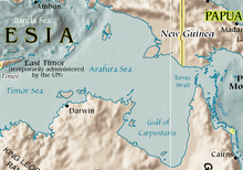
The Arafura Sea is a tropical sea that lies between the Australian continent and the island of New Guinea .
geography
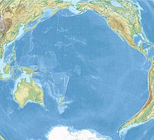
It is a tributary of the Pacific Ocean , but is sometimes also considered part of the Indian Ocean due to its location and covers an area of around 650,000 km².
The Arafura Sea forms part of the Australasian Mediterranean Sea . It borders the Timor Sea to the west and the Coral Sea to the east via the Torres Strait . The northern boundary is formed in the western part by the Tanimbar and Aru Islands belonging to the Indonesian Moluccas , which separate the Arafura Sea from the Banda Sea and the Seram Sea . Further to the east, the southern coasts of the Indonesian province of Papua and Papua New Guinea represent the edge of the sea. The southern coasts of the Arafura Sea belong to the Australian state of Queensland and the Northern Territory . They are clearly structured by the two large peninsulas Cape York and Arnhem Land. The area cut deep into the Australian continent between the two peninsulas is called the Gulf of Carpentaria .
The sea lies mostly on the Arafura base and has an average depth of around 150 m. The relatively shallow depth is explained by the fact that the Arafura Sea together with New Guinea and Australia formed the Sahul continent in the last ice age . The native inhabitants of Australia were able to immigrate from Asia via the land mass at that time. The deepest point is the Arutief at 3,680 m . The water surface is very warm all year round.
use
The Arafurasee is an important fishing area for the neighboring regions, but is now at great risk due to overfishing and pollution. The main catches are tuna , mackerel , various types of sardines and shrimp , which are also exported. It is believed that there are rich deposits of oil and natural gas under the shelf .
To protect the waters and the organisms living in them, an association of governmental and non-governmental organizations under the name "The Arafura and Timor Seas Experts Forum (ATSEF)" was formed in 2003 , which is responsible for research and cooperation between the states of Australia, Indonesia and Papua New Guinea and East Timor coordinated.
The Arafura Games are named after the Arafurasee .
Web links
- IHO map with the borders of the Arafura Sea
- IHO description of the borders of the Arafura Sea: 48th East Indian Archipelago (Indonesia), (h) Arafura Sea (PDF; 994 kB)
Individual evidence
- ^ Klaus Viedebantt : Australia: Travel with insider tips . Mair Dumont Marco Polo, 1999, ISBN 978-3-8297-0000-9 , pp. 91 ( limited preview in Google Book search).
- ↑ Encyclopædia Britannica : Entry Arafura-Sea (English)
- ↑ Arafurasee short description on Wissen.de ( Memento of the original from November 13, 2011 in the Internet Archive ) Info: The archive link was inserted automatically and has not yet been checked. Please check the original and archive link according to the instructions and then remove this notice.
- ↑ Arafura Lake . In: Meyers Großes Konversations-Lexikon . 6th edition. Volume 1, Bibliographisches Institut, Leipzig / Vienna 1905, p. 663. , Accessed on January 8, 2011
- ^ Albert Rolff: Petroleum in Southeast Asia and its economic significance for Western Europe . Duncker & Humblot, 1978, ISBN 978-3-428-04139-8 , pp. 48 ( limited preview in Google Book search).
- ↑ Basic information on the Arafura Seas-Timor Seas Experts Forum
- ↑ homepage of the Arafura Games ( Memento of the original from September 12, 2010 in the Internet Archive ) Info: The archive link was inserted automatically and has not yet been checked. Please check the original and archive link according to the instructions and then remove this notice.


