Seramsee
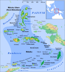
The Seram Sea (Indonesian: Laut Seram ) is a 12,000 square kilometer tributary sea to the Pacific Ocean . It is located in the Malay Archipelago and is a tropical sea .
To the northwest is the Molucca Sea , to the northeast the Halmaherasee , to the southeast the Arafura Sea and to the south the Banda Sea .
Misool Island is located in the middle of the Seram Sea. According to the third edition of Limits of Oceans and Seas from 1953 by the International Hydrographic Organization , the northern limit of the Seram Sea stretches roughly from the easternmost part of the Sula Islands over the islands of Obira , Tobalai , Kekek , Pisang to Kofiau , then on to Tanjong Sele, in the west of the Vogelkop peninsula in New Guinea . Further south of this is Bentuni Bay with one of the world's largest mangrove areas on earth. On the southern side, the border stretches from Karoefa in New Guinea via Adi to Kei Besar , then on to the Watubela Islands and the Gorom Islands and finally over the island of Seram and Buru .
Under the sea extends with up to 5,318 meters deep Burubecken a geomorphology threshold .
See also
Individual evidence
- ^ Limits of Oceans and Seas. (PDF; 994 kB) International Hydrographic Organization , 1953, accessed on August 4, 2010 (English).
Coordinates: 3 ° S , 131 ° E
