Timor
| Timor | |
|---|---|
| Photo from space | |
| Waters | Banda Sea , Sawu Sea , Timor Sea |
| Archipelago | Timor Archipelago |
| Geographical location | 9 ° 14 ′ S , 124 ° 56 ′ E |
| length | 476 km |
| width | 102 km |
| surface | 33,850 km² |
| Highest elevation |
Tatamailau 2963 m |
| Residents | about 2,800,000 83 inhabitants / km² |
| main place | Dili , Kupang |
The island of Timor is the largest of the Lesser Sunda Islands at 33,850 km² . The Timor Archipelago including Roti is the largest archipelago in the eastern Lesser Sunda Islands in the eastern Malay Archipelago . Timor has about three million inhabitants. The island is divided into the Indonesian West Timor and the state of East Timor with its exclave Oe-Cusse Ambeno .
geography
Overview
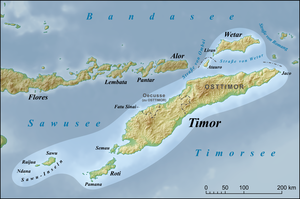
The island of Timor (approx. 125 ° East and 9 ° South) is 476 km long and up to 102 km wide and extends in a west-east direction, with the western tip being 216 km more south than the eastern tip. Timor is the easternmost of the Lesser Sunda Islands ( indon. Timur , east). Flores is a few hundred kilometers to the west-northwest across the Sawu Sea . To the north are the Alora Archipelago , across the Strait of Ombai , and Wetar , across the Strait of Wetar . New Guinea is 1100 kilometers east of Timor , across the Banda Sea . To the south, across the Timor Sea, is Australia . Offshore islands are Semau , Roti , Fatu Sinai , Atauro and Jaco .
The island is politically divided into two parts. The Indonesian West Timor (Timor Barat), which belongs to the Indonesian province of East Nusa Tenggara , covers 16,861.25 km² and is inhabited by 1,854,767 people. The capital is Kupang , the largest city on the island. The Democratic Republic of East Timor (officially Timor-Leste ), which also includes the exclave Oe-Cusse Ambeno on the northwest coast of West Timor and the smaller islands of Atauro and Jaco , has 14,919 km² and 1,066,582 inhabitants. The capital of East Timor is Dili .
landscape

Timor is mountainous in the central part and covered by savannah ; the originally existing monsoon forest has almost completely disappeared. The island used to be famous for its large stocks of sandalwood . As a commodity it reached China , India and Arabia . Today the stocks are severely depleted. State reforestation efforts in West and East Timor are still in their infancy. The dry character of the savannah landscape and the unreliability of monsoon rainfall do not allow extensive wet rice cultivation . Only in the estuary of the larger rivers, which allow artificial irrigation, are larger areas with rice cultivation to be found.
The main food in the drier mountain regions is the corn imported by the Portuguese . It is cultivated in slash-and-burn agriculture in the house gardens of the settlements. Dry rice , which must have been a more important staple food in the past, is disappearing today due to the scarcity of water resources. Various sources say that millet once had a great ritual significance for the island's cultures . Cassava and various types of vegetables and fruits and keeping small animals, especially poultry , complement the food production.
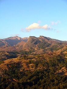
Several mountain ranges rise in the center. The highest point in Timor is the Tatamailau in East Timor ( 2963 m ). They influence the local climate and the possibilities of agriculture. The rivers in the north run dry outside the rainy season if they are not fed from the south.
geology
Timor lies on the outer edge of the so-called Banda Arch , which is part of an extension of the Pacific Ring of Fire and forms a chain of islands around the Banda Sea. In an oceanic subduction zone , the northwest corner of the Australian plate is pushed under the Eurasian plate . Among other things, this leads to the ongoing elevation of the mountain range on Timor, which, as the central mountainous region, runs through the entire island from southwest to northeast. In East Timor, some areas lift between 1 and 1.6 mm per year. Geologically speaking, Timor is still very young, as the island was only lifted out of the sea in the last four million years.
climate
The local climate is tropical , generally hot and humid, and is characterized by pronounced rainy and dry seasons. During the eastern monsoon between May and November there is often persistent drought, the north coast then receives practically no rain and the brown landscape is parched. The cooler mountain regions in the center of the island and the south coast get occasional rain in the dry season, so the landscape here remains green. The rainy season lasts from late November to April. During this time the fields are cultivated again. With the rain often comes floods, the dry river beds can fill up in a very short time and swell into large rivers, dragging the earth and debris with them and breaking roads.
The temperature in the dry season is around 30 to 35 ° C in the lowlands (20 ° C at night). Parts of the north coast reach temperatures of over 35 ° C at the end of the dry season, but with low humidity and almost no precipitation. In the mountains it is also warm to hot during the day, but at night the temperature can drop to below 15 ° C and significantly lower at higher altitudes.

| Jan | Feb | Mar | Apr | May | Jun | Jul | Aug | Sep | Oct | Nov | Dec | year | |
|---|---|---|---|---|---|---|---|---|---|---|---|---|---|
| Average temperature [° C] | 28.3 | 28.3 | 28.3 | 28.3 | 28.1 | 27.5 | 26.7 | 26.4 | 26.4 | 27.2 | 28.6 | 28.9 | 27.8 |
| Average daily maximum [° C] | 31.1 | 31.1 | 31.7 | 31.7 | 31.7 | 31.1 | 30.6 | 30.6 | 30.6 | 31.1 | 32.2 | 32.2 | 31.3 |
| Average daily minimum [° C] | 25.6 | 25.6 | 25.0 | 25.0 | 24.4 | 23.9 | 22.8 | 22.2 | 22.2 | 23.3 | 25.6 | 25.6 | 24.2 |
| Absolute temperature maximum [° C] | 36.1 | 35.0 | 36.7 | 36.1 | 35.0 | 36.7 | 33.3 | 35.0 | 33.9 | 33.9 | 35.0 | 35.0 | 36.7 |
| Absolute temperature minimum [° C] | 21.1 | 22.8 | 20.0 | 21.7 | 20.6 | 18.9 | 16.1 | 17.2 | 16.1 | 18.3 | 21.1 | 22.8 | 16.1 |
| Average rainfall [mm] | 127.0 | 119.4 | 137.2 | 109.2 | 86.4 | 25.4 | 12.7 | 5.1 | 7.6 | 22.9 | 50.8 | 139.7 | 843.4 |
| Maximum amount of rain [mm] | 161.9 | 143.9 | 157.4 | 148.4 | 149.8 | 139.2 | 137.1 | 130.1 | 127.5 | 149.6 | 159.9 | 168.6 | 1773.5 |
| Average number of rainy days | 13 | 13 | 11 | 9 | 6th | 4th | 3 | 1 | 1 | 2 | 6th | 11 | 80 |
| Average duration of sunshine [h / d] | 6.1 | 5.7 | 7.6 | 7.8 | 8.6 | 8.2 | 8.8 | 9.4 | 9.6 | 9.6 | 9.0 | 7.1 | 8.1 |
| Average water temperature [° C] | 26.7 | 26.4 | 26.4 | 27.2 | 28.6 | 28.9 | 28.3 | 28.3 | 28.3 | 28.3 | 28.1 | 27.5 | 27.8 |
| Average relative humidity [%] | 80 | 82 | 80 | 77 | 75 | 72 | 71 | 70 | 71 | 72 | 73 | 77 | 75 |
| Average wind speed [km / h] | 10 | 8th | 9 | 8th | 7th | 8th | 10 | 12 | 11 | 11 | 11 | 10 | - |
| season | Rainy season | dry season | RZ | ||||||||||
Source: Phytosociological Research Center ; wetterkontor.de ; Direcção Nacional de Estatística: Timor-Leste in figures 2011 (PDF; 3.8 MB) , accessed on May 5, 2013
fauna and Flora
Timor belongs to the area of Wallacea . Thus, the fauna and flora of Timor is part of the biogeographical transition zone between the Asian and Australian flora and fauna, which is why the fauna and flora of the island is composed of both species from the Asian region and species from the Australian region. Most land animals, however, are recruited from Asian animal groups, while relatively few come from Australia. Since many bird species only occur in this region, Timor was declared a Timor and Wetar Endemic Bird Area , together with Wetar and some smaller, offshore islands .
history


Little is known of the history of Timor before the 16th century. The island used to be divided into many small kingdoms, which were divided into neighboring Suco units ( Bahasa Indonesia : suku for ethnic group ). The traditional rulers were called Liurais .
It is possible that Timor was a vassal of the Majapahit Empire from the 14th century . In the Nagarakertagama , the heroic epic of the time, a long list of tributary vassal states of Majapahit is given. Timor is one of them. However, the Portuguese scribe Tomé Pires noted in the 16th century that all islands east of Java are called Timor , as the local language uses the word "Timor" to denote the east.
The Portuguese navigator António de Abreu sighted Timor in 1512 as the first European looking for the Spice Islands , but probably did not set foot on them. Only later expeditions landed. This happened at the latest in 1515 at the later Lifau . Due to the sandalwood stock of the island, the Portuguese, who at that time had the predominant position in the region, founded a fort in the western half in Lifau, near today's Pante Macassar . Over a hundred years later, the Dutch landed in Kupang , gradually displacing the Portuguese from most of western Timor.
William Bligh reached Kupang with his followers in 1789 after being abandoned at sea during the mutiny on the Bounty .
Even a border treaty in 1859 could not settle the protracted disputes over supremacy on Timor between the Dutch in the west and the Portuguese in the east. It was not until 1916 that the limit that still exists today was set. In the western part of the island, the exclave Oe-Cusse Ambeno remained on the northwest coast near Portugal.
During the Second World War , the entire island was occupied by the Japanese . It came to the battle of Timor , in which Australian units fought in guerrilla tactics against the Japanese occupiers. Timorese were also involved in the fighting on both sides. After the war, West Timor became a part of Indonesia in 1949, East Timor remained Portuguese until the colony declared itself independent in 1975. However, Indonesia occupied it only nine days after the declaration of independence. Only after 24 years of war and three years of administration by the United Nations did East Timor become independent in 2002.
population


Individual ethnic groups on the island, especially the Atoin Meto , who settled in West Timor , only became known in Europe through the increasing scientific interest of the Dutch colonial power since the 19th century.
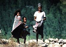
The different cultures of Timor depend economically on foods such as corn, rice and sweet potatoes. In the highland regions, which are populated by the Makasae in east East Timor , for example , maize and rice cultivation dominate, with the Tetum , who inhabit the plains, the opposite is true. The same applies to domesticated animals: while buffalo and pigs are bred everywhere in Timor, the buffalo, for example, is more important than the pig for the Makasae. In other regions, for example in the East Tetum, the buffalo are of secondary economic importance in contrast to the pig. Other pets are chickens, goats, and horses.
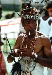
The cultural traditions of the Timorese are characterized by different social institutions. The social organizations of the individual Timor societies can be structured matrilinear / uxorilocal or patrilinear / patrilocal ; individual groups fluctuate between these possibilities of family organization. While the social organization of the Atoin Meto and probably also the Baikeno of East Timor is characterized by a symmetrical alliance, the asymmetrical alliance can be found, for example, with the Makasae , Naueti and Fataluku . In the case of the Tetum, bilateral or cognate ancestry rules prevail.
Weddings and economic-ritual alliances that are formed along these organizational structures are controlled by the social institution of the so-called “bride price”, in which women and goods that circulate between social groups always flow in a certain direction. Patrilineal and patrilocal organizations distinguish themselves from matrilineal and uxorilocal organizations by impressive goods transactions. In most Timorian cultures, the completeness of the “bride price” presented determines the couple's residence. If no or only an inadequate “bride price” is paid, the husband lives in the woman-giver lineage; the children remain entirely in this lineage.
The ethnography of most of Timor’s ethnic groups is only approximately known and published. The cultures of the Kairui , Naueti, Galoli , Baikeno and Idaté are particularly affected . In contrast, the Atoin Meto, the western Tetum, the Bunak , the Mambai and the Makasae are well known.
The Atoin Meto probably represent the original population of Timor. Immigrants from West Indonesia and Malaysia ( Malacca ) who reached Timor from Larantuka ( Flores ) displaced them from their settlement areas in Central Timor. The last migrants were the ancestors of the Tetum (Belu), who occupied the Benaine Plain in the modern administrative district of Wehale ( also Waihale or Wehali ), Timor's most fertile landscape, in the 14th century .
The Atoin Meto were pushed further and further west by the conquest of land by the immigrants, the empire of Wehale dominated the eastern kingdoms in the form of a ritual-political confederation until the arrival of the Europeans for several centuries. Following the Wehale model, the kingdom of Sonba'i emerged in West Timor .
Despite the missionaries' zeal for conversion since the 16th century, the Christianization has only been successful in the last 50 years. Since then, Christianization has caused a strong cultural change that is increasingly pushing traditional beliefs underground. At the end of the Portuguese colonial period in 1975 , the proportion of Catholics in East Timor was only 30%. But since the Catholic faith functioned as a link between the various ethnic groups in the fight against the Indonesian occupation, their share rose to 92% (Christians overall: 95%). In no other country on earth has the Catholic Church achieved such a large increase.
languages
In the Indonesian part of Timor, Bahasa Indonesia is the official language, in East Timor it is the Austronesian Tetum and Portuguese . Bahasa Indonesia is still used by many as a lingua franca in the east, as the use of Portuguese was forbidden during the Indonesian occupation . According to Article 159 of the East Timorese Constitution , Bahasa Indonesia and English are working languages.
There are also 15 national languages recognized by the constitution in East Timor. These are the Austronesian languages Atauru (a dialect of Wetar ), Baikeno (a dialect of Uab Meto in the exclave Oe-Cusse Ambeno), Bekais , Galoli , Habun , Idalaka , Kawaimina , Makuva , Mambai , Kemak and Tokodede and the Papuan Languages Bunak , Fataluku , Makalero and Makasae .
The name belu (friend) of the Atoin Meto characterizes this conglomerate of ethnicities and languages on the eastern side of the former Dutch-Portuguese border and, in contrast to the Atoin Meto, refers to the many common cultural characteristics of the East Timor ethnicities.
In West Timor, the language of the Atoin Meto, the Uab Meto , dominates, whose Baikeno dialect is also spoken in the East Timorese Oe-Cusse Ambeno. Tetum, Bekais and Bunak ( Bunaq ) can also be found in both parts of the island. The languages Helong and Rotinese , which are related to the Uab Meto, are also spoken. Helong was the original language in Kupang , but has been largely replaced by Bahasa Indonesia and is only spoken in a few villages south of the city along the east coast and on the island of Semau . Rotinese, which comes from the island of Roti , is split into many dialects. 123,000 speakers of Rotinese are found in many districts of West Timor due to the resettlement program that the Dutch carried out in the 19th century.
See also
- The good crocodile , Timor’s creation myth
- Great Timor
- List of shared islands
Web links
- The Languages of East Timor ( January 19, 2008 memento in the Internet Archive )
Individual evidence
- ↑ Nova Roosmawati and Ron Harris: Surface uplift history of the incipient Banda arc-continent collision: Geology and synorogenic foraminifera of Red and Savu Islands, Indonesia. Tectonophysics, 479: 95-110, 2009 doi : 10.1016 / j.tecto.2009.04.009
- ↑ Important Bird Areas in Timor-Leste ( Memento of the original from November 22, 2008 in the Internet Archive ) Info: The archive link was automatically inserted and has not yet been checked. Please check the original and archive link according to the instructions and then remove this notice. (English) (PDF file; 1.87 MB)


