Ribbon bow

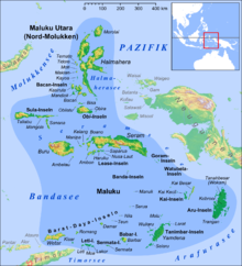
The Ribbon Arch consists of two island chains in the west of the Malay Archipelago , which were created when the Australian and Eurasian plates collide .
Overview
A distinction is made between the inside and the outside ribbon bow. The islands lying there enclose the Banda Sea in the south and east and thus separate it from the Timor Sea . In the west lies the Sawusee between the two arches . The islands to the west form the Lesser Sunda Islands , while the east belong to the Moluccas . Apart from the national territory of East Timor , the islands and archipelagos located here belong to Indonesia .
The Wallace Line , which marks the transition between the Asian and Australian fauna, runs through the arch .
The inner ribbon bow
The Inner Banda Arch is of volcanic origin and extends from Komodo , through Flores , Solor , Adonara , Lembata , Pantar and Alor , to Serua and Kekeh-Besar , the easternmost of the Barat-Daya Islands .
The outer ribbon bow
The outer ribbon arch is older and was created by the folding of the sea floor. In an oceanic subduction zone , the northwest corner of the Australian plate is pushed under the Eurasian plate. The arc extends from Sawu and Raijua in the West, about Roti , Semau , Timor , the Leti Islands , Sermata , Babar , the Tanimbarinseln , to the Kei Islands in the East before about the Watubela archipelago and Gorong archipelago again direction West swings to Seram , Ambon and Buru .
supporting documents
- MG Audley-Charles: Timor-Tanimbar Trough: the foreland basin of the evolving Banda orogen , 1986, Spec. Publs int. Ass. Sediment, 8: 91-102
Coordinates: 8 ° 59 ′ S , 125 ° 19 ′ E