Leti Islands
| Leti Islands | ||
|---|---|---|
| The Leti Islands | ||
| Waters | Banda Sea , Timor Sea | |
| archipelago | Moluccas | |
| Geographical location | 8 ° 11 ′ S , 127 ° 56 ′ E | |
|
|
||
| Number of islands | 3 | |
| Main island | Moa | |
| Total land area | 750 km² | |
| Residents | 16,600 (2010) | |
The Indonesian Leti Islands ( indon. Kepulauan Leti ) belong to the Southern Moluccas .
geography
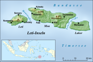
The three Leti Islands are east of Timor and southeast of Wetar . The largest island is Moa with the largest settlement Pati in the south. West of Moa, across the Moastraße , is the smaller Leti with the place Serwaru on the north coast, east of the Lakorstraße , the island Lakor with the place Werwawan (Warwawang, Werwaru) on the north coast. The total area of the islands is about 750 square kilometers.
The Leti Islands form the Kecamatans Leti Moa Lakor , Pulau Lakor and Pulau Moa , ( Kabupaten southwestern Moluccas ( Maluku Barat Daya ), Maluku Province ). The main town of Kabupaten is Tiakur , Moa on the west coast.
Residents
About 16,600 people live on the archipelago, 7,000 of them on the island of Leti. The Austronesian language Leti is spoken there .
Traditionally, there was a close trading relationship with the Fataluku from Tutuala in East Timor , which also led to a cultural exchange. East Timor is just a day's sailing away from Leti. A commodity were Batik - sarongs . However, since East Timor's independence in 2002, traditional trade across national borders has declined.
Web links
Individual evidence
- ↑ a b Indahnesia: The Leti Islands , accessed on 22 December 2012
- ↑ Penduduk Indonesia menurut desa 2010 ( Memento from March 27, 2014 in the Internet Archive ) (Indonesian; PDF; 6.0 MB), accessed on January 26, 2013
- ↑ Undang Undang Republic of Indonesia nomor 31 tahun 2008 tentang Pembentukan Kabupaten Maluku Barat Daya Di Provinsi Maluku ( Memento of the original from July 21, 2011 in the Internet Archive ) Info: The archive link was inserted automatically and has not yet been checked. Please check the original and archive link according to the instructions and then remove this notice. ( Law of the Republic of Indonesia No. 31 of 2008 on the establishment of Southwest Maluku District in Maluku Province )
- ↑ Lisa Palmer, Demétrio do Amaral de Carvalho : Nation building and resource management: The politics of 'nature' in Timor Leste ( Memento of the original from February 1, 2014 in the Internet Archive ) Info: The archive link was inserted automatically and has not yet been checked. Please check the original and archive link according to the instructions and then remove this notice. (PDF; 343 kB) , accessed on December 28, 2012


