
Babar Islands
| Babar Islands | ||
|---|---|---|
 |
||
| Waters | Banda Sea , Timor Sea | |
| archipelago | Moluccas | |
| Geographical location | 7 ° 52 ′ S , 129 ° 36 ′ E | |
|
||
| Number of islands | 6th | |
| Main island | Babar | |
 |
||

The Indonesian Babar Islands ( Indonesian Kepulauan Babar ) belong to the Southern Moluccas .
geography
overview

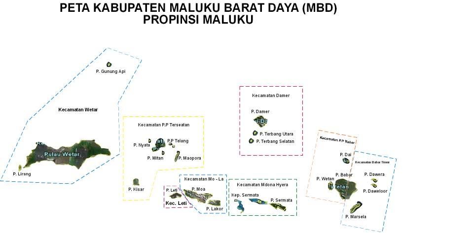
The largest island in the group is Babar . West of it is the second largest island Wetan , south the number three Masela and north the three small islands Dai , Dawera and Daweloor . To the west of the Babar Islands are the Sermata Islands , to the east the Tanimbar Islands . Together they are part of the outer ribbon arc , which Timor further to the west also belongs to. To the south are the Timor Sea and the Arafura Sea , to the north the Banda Sea .
While Babar reaches a height of 833 m , is thinly forested with mountain forests and has year-round fresh water sources, the other islands in the group are mostly only flat limestone islands. Dai alone is made of granite. The small islands are sterile, so that the people there, unlike those on Babar, do not have to live from agriculture, but from fishing and handicrafts. Rainwater has to be collected here in cisterns for the dry season (September to December).
Administrative division
In the middle of the main island of Babar there is a straight line between the subdistrict ( Kecamatan ) Pulau-Pulau Babar in the west and Babar Timur ( East Babar ) in the east. The islands Wetan and Dai belong to Pulau-Pulau Babar, the islands Masela, Dawera and Daweloor belong to Babar Timur. Both sub-districts belong to the administrative district ( Kabupaten ) of the southwestern Moluccas ( Maluku Province ). The main town of Pulau-Pulau Babar is Tepa on the west coast of Babar and of Babar Timur Letwurung on the east coast.
Residents

In contrast to the Malays in western Indonesia, the original population is of Melanesian origin. Most are Protestants and belong to the Gereja Protestan Maluku (GPM), which has its origins in the Dutch Reformed Church . The GPM has 56 places of worship on the Babar Islands. There is also a Catholic Church, a Seventh-day Adventist Church and a Pentecostal Church . There is also a mosque in Tepa .
transport
The Babar Islands can only be reached by boat.
Web links
Individual evidence
- ↑ a b Map of the Southwest Moluccas ( Memento from November 22, 2011 in the Internet Archive )
- ^ Britannica: Babar Island
- ^ Map of the Southwest Moluccas