
Tutuala
| Tutuala | |||

|
|||

|
|||
| Data | |||
| surface | 92.10 km² | ||
| population | 1,252 (2015) | ||
| Chefe de Suco | António da Fonseca (election 2009) |
||
| Aldeias | Population (2015) | ||
| Ioro | 396 | ||
| Pitileti | 309 | ||
| Tchailoro | 6th | ||
| Vero | 541 | ||
|
|||

Tutuala is a village and suco in the East Timorese administrative office of Tutuala ( Lautém municipality ), on the eastern tip of the island of Timor . In 1936 Tutuala was renamed Nova Sagres by the Portuguese . But the name did not catch on and a few years after the Second World War , the old name was reverted to.
geography
| Tutuala | ||
| places | position | height |
| Ioro | 8 ° 24 ' S , 127 ° 15' E | 303 m |
| Pitileti | 8 ° 24 ' S , 127 ° 16' E | ? |
| Tchailoro | 8 ° 24 ' S , 127 ° 15' E | 303 m |
| Tutuala | 8 ° 24 ' S , 127 ° 15' E | 71 m |
| Vero | 8 ° 24 ' S , 127 ° 15' E | 303 m |
The Suco Tutuala forms the easternmost point of the island of Timor. To the west is Suco Mehara, which also belongs to the Tutuala administrative office, and Suco Muapitine, which belongs to the Lospalos administrative office . In the north is the Banda Sea with the Strait of Wetar ( tetum Tasi Feto , the women's sea) and in the south the Timor Sea ( tetum Tasi Mane , the men's sea). At the east end of Timor , a small stretch of coast runs from Cape Cutcha ( Cabo Cutcha ) in the north to the south. Opposite the beach of Valu , on the other side of a 600 meter wide canal, is the island of Jaco , which belongs to the Suco Tutuala. The Vero River flows into the Timor Sea on the south bank of the Sucos. To the northwest of the town of Tutuala lies the small Lagoa Zeleha , a lake that is fed by a river and connected to the Wetar Strait by its outflow.
The village of Tutuala is the main town of the administrative office of the same name. The place is located about 190 km as the crow flies east of the state capital Dili , at an altitude of 71 m , in the north of Sucos. The municipal capital Lospalos is 32 km away. Tutuala can be reached from Lospalos by minibus ( Mikrolét ) on a poorly developed road. Cape Cutcha ( Cabo Cutcha ) is located near the village , at the easternmost end of the island of Timor. To the cape and the beach of Valu, opposite the island of Jaco, an unpaved road leads steeply down through the forest.
Most of the houses are simple huts. At the eastern end of the village there is a colonial villa that houses a guesthouse ( pousada ). The colonial administrator Tutualas used to reside here. The primary school (Escola Primaria Tutuala) and the police station are of regional importance . In addition, the settlement center also has a medical station. The Church of Nossa Senhora de Fátima was built in 1972/73 by the Salesian Father Bernardo João Soares, who came from Cape Verde . The Liurai Joaquim Fonseca de Tutuala made the land available. The church is dedicated to the Nossa Senhora de Fátima .
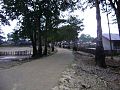
Main street of Tutuala
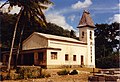
Nossa Senhora de Fátima , the church of Tutuala

Pousada from Tutuala

Tutuala village shop


In the vicinity of Tutuala are the places Ioro ( Loro ), Tchailoro ( Chailoro ) and Vero to the southwest and the village of Pitileti ( Piti Leti , Petileti ) to the southeast . To the west of Vero, on the road to Mehara, lies the source of Came Ira .
The four Aldeias Ioro , Pitileti , Tchailoro and Vero are located in the Suco .
Before the 2015 territorial reform, Tutuala had an area of 119.69 km². The border with Mehara was straightened and Tutuala ceded areas in the southwest to Muapitine. Now Tutuala has an area of 92.10 km².
There are over 30 limestone caves and rock overhangs in the Tutuala Administration Office. For example, Ile Kére Kére ( Ili-kere-kere ), Lene Hara , Acitaukuru and Jerimalai are close to Tutuala . The cave of the Ponors Lenetulu extends at least 170 meters below the earth, to a depth of 51 meters. The main hall impresses with a width of more than ten meters.
The Suco is part of the Nino Konis Santana National Park .
| Jan | Feb | Mar | Apr | May | Jun | Jul | Aug | Sep | Oct | Nov | Dec | year | |
|---|---|---|---|---|---|---|---|---|---|---|---|---|---|
| Average daily maximum [° C] | 30th | 30th | 31 | 32 | 32 | 32 | 32 | 33 | 33 | 32 | 31 | 31 | 33 |
| Average daily minimum [° C] | 23 | 23 | 23 | 24 | 24 | 24 | 24 | 24 | 24 | 24 | 24 | 24 | 23 |
| Average rainfall [mm] | 511.8 | 446.5 | 336.3 | 210.8 | 238.3 | 175.1 | 182.9 | 160.3 | 170.3 | 186.5 | 324.7 | 413.6 | 3357.1 |
| season | Rainy season | dry season | Rainy season | ||||||||||
Residents
1252 (2015) live in Suco Tutuala, of which 615 are men and 637 women. The population density is 13.6 inhabitants / km². There are 258 households in the Suco. Over 99% of the population list Fataluku as their mother tongue. A minority speaks Tetum Prasa . In addition to songs on Fataluku, some are also sung in the “commercial language” at celebrations. This is Leti , the language of the Indonesian Leti Islands , which can be reached within a day by sailing. Traditionally, there was a lively trade between Tutuala and Leti Islands, among others Batik - sarongs . Since East Timor became independent in 2002, trade across national borders has declined.
history


Thousands of pictures have been painted on the walls of Tutuala's over 30 caves and rocky overhangs. For example in Ile Kére Kére and Lene Hara. More rock paintings can be found on the cliffs of Tutuala and Tunu Taraleu , in Lene Kici and Lene Cécé . In Jerimalai, archaeologists discovered 42,000 year old relics.
Like many of the ethnic groups of Timor, each clan of the Fataluku (ratu) has its own founding myth, which tells of the immigration of the ancestors to Timor. The Kati ratu and the Tutuala ratu are special . Their legends tell that they come from their current homeland, which indicates that they may have been in Timor longer than other Fataluku and were culturally assimilated by them. The elders of Tutuala ratu are traditionally called "Lord of the Land" (mua ocawa) . They therefore have special rights and obligations during ceremonies.
In 1999 there was violence in Tutuala in the context of the independence referendum in East Timor in 1999 . Years later you could still see the ruins of destroyed buildings in the village.
- Pictures from 1970

Ioro
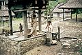
Ioro

Tchailoro


politics
In the elections of 2004/2005 was António da Fonseca elected Chefe de Suco and in 2009 re-elected.
Sons and daughters
- Nino Konis Santana (* 1957 in Vero; † 1998), East Timorese freedom fighter
- Arsénio Pereira da Silva (* 1973), East Timorese activist and politician
Web links
- Results of the 2010 census for the Suco Tutuala ( tetum ; PDF; 8.6 MB)
- Results of the 2015 census for the Suco Tutuala (tetum; PDF)
- Seeds of Life: Suco information sheets Tutuala (tetum)
Individual evidence
- ↑ a b c d Direcção-Geral de Estatística : Results of the 2015 census , accessed on November 23, 2016.
- ↑ Boletim Oficial, XXXVII Ano - Numero 21, Govêrno Colonial, Diploma Legislativo N ° 85, May 27, 1936.
- ^ João Soares: Novo Atlas Escolar Português , 5th updated edition, Lisboa 1954
- ↑ Fallingrain.com: Directory of Cities, Towns, and Regions in East Timor
- ↑ List of polling stations for the parliamentary elections in East Timor 2007 (PDF file; 118 kB)
- ↑ UNMIT card from August 2008 ( Memento from December 3, 2011 in the Internet Archive ) (PDF; 389 kB)
- ^ Timor-Leste GIS-Portal ( Memento from June 30, 2007 in the Internet Archive )
- ↑ Helen K. Larson, Duncan Buckle, Jessica Lynas, Andrew Storey, Chris Humphrey: Additional records of freshwater fishes from Timor-Leste, with notes on the fish fauna of the unique closed Irasiquero River system , The Beagle, Records of the Museums and Art Galleries of the Northern Territory, 2007 23: 131-135 .
- ↑ Jornal da Républica with the Diploma Ministerial n. 199/09 ( Memento of February 3, 2010 in the Internet Archive ) (Portuguese; PDF; 323 kB)
- ↑ Direcção Nacional de Estatística: Population Distribution by Administrative Areas Volume 2 English ( Memento from January 5, 2017 in the Internet Archive ) (Census 2010; PDF; 22.6 MB)
- ↑ a b Sapo.tl: Timor-Leste tem mais de 30 grutas e abrigos com arte rupestre , February 11, 2014 , accessed on September 9, 2014.
- ↑ Fatuk-Kuak Hosi Timor Lorosa'e: Caves of Timor-Leste , pp. 32–34, accessed on January 1, 2020.
- ^ Tutuala Weather, Indonesia Weather Averages . Worldweather online. Retrieved August 12, 2013.
- ↑ Results of the 2010 census for the Suco Tutuala ( tetum ; PDF; 8.6 MB)
- ↑ Lisa Palmer, Demétrio do Amaral de Carvalho : Nation building and resource management: The politics of 'nature'in Timor Leste ( Memento from February 1, 2014 in the Internet Archive ) (PDF; 343 kB) , accessed on December 28, 2012
- ^ Sue O'Connor: Nine New Painted Rock Art Sites from East Timor in the Context of the Western Pacific Region , pp. 19 ff., Asia Perspectives, Vol. 42, No.1, 2003 , accessed April 6, 2020.
- ↑ Sue O'Connor , Matthew Spriggs, Peter Veth: Excavation at Lene Hara Cave establishes occupation in East Timor at least 30,000-35,000 years ago , in: Antiquity März 2002, 76, 291, p. 45 ( Memento from September 23, 2015 in the Internet Archive ) (PDF; 1.2 MB)
- ↑ Andrew McWilliam: Austronesians in linguistic disguise: Fataluku cultural fusion in East Timor ( Memento of November 7, 2014 in the Internet Archive ) (PDF; 171 kB)
- ↑ John Norman Miksic, Geok Yian Goh, Sue O'Connor: Rethinking Cultural Resource Management in South East Asia: Preservation, Development, and neglect. 2011, ISBN 978-0-85728-389-4 .
- ↑ Secretariado Técnico de Administração Eleitoral STAE: Eleições para Liderança Comunitária 2004/2005 - Resultados ( Memento of August 4, 2010 in the Internet Archive )
- ↑ Secretariado Técnico de Administração Eleitoral STAE: Eleições para Liderança Comunitária 2009 - Resultados ( Memento of August 4, 2010 in the Internet Archive )