Vero (Timor Sea)
|
Vero Rio Vero |
||
|
The Vero flows south of the Tutuala Administrative Office |
||
| Data | ||
| location | Administrative Office Tutuala , East Timor | |
| River system | Vero | |
| source | Tutuala 8 ° 25 ′ 8 ″ S , 127 ° 14 ′ 2 ″ O |
|
| muzzle | in the Timor Sea coordinates: 8 ° 28 '40 " S , 127 ° 13' 58" E 8 ° 28 '40 " S , 127 ° 13' 58" E
|
|
| length | 22.6 km | |
|
Mouth of the Vero. In the background the Paitchau mountain range and dense tropical forest |
||
The Vero ( Rio Vero ) is a river in East Timor .
course
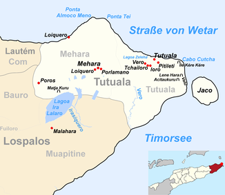
The river flows through the Suco Tutuala , in the extreme east of the island of Timor and flows into the Timor Sea after 22.6 km . The Vero touches the border area of the Sucos Muapitine shortly before its mouth .
The river is fed by several sources. The Fa Fa is a large pool under a waterfall. Han ( German to eat ) is a year-round spring with a basin with gravel and rubble. Sair Ira on a hill consists of several basins. In Nair Ete , the actual spring is called Ira Ina ( German mother of water ). It seeps from the embankment into a stream.
colonization
The area is sparsely populated and part of the Nino Konis Santana National Park .
fauna
The following fish species have been found in the Vero or its sources:
- Anguilla celebesensis
- Anguilla marmorata
- Belobranchus belobranchus
- Bunuka gyrinoides
- Eleotris fusca
- Giuris magaritacea
- Sicyopterus caeruleus
- Sicyopterus hageni
- Sicyopterus micrurus
- Sicoypus zosterophorum
- Stiphodon semoni
Web links
Individual evidence
- ↑ a b Helen K. Larson, Duncan Buckle, Jessica Lynas, Andrew Storey, Chris Humphrey: Additional records of freshwater fishes from Timor-Leste, with notes on the fish fauna of the unique closed Irasiquero River system , The Beagle, Records of the Museums and Art Galleries of the Northern Territory, 2007 23: 131-135 .


