
Administrative division of East Timor

The current division of the administrative structure of East Timor was determined in the ministerial document 6/2003 of July 29, 2003 and only slightly changed on July 14, 2004 and September 15, 2009. In 2014 the names of the administrative units were renamed and in 2015 the administrative boundaries were partly changed again. 2017 was followed by the ministerial document 16/2017 the creation of ten new Sucos .
Overview
East Timor consists of the eastern part of the island of Timor , the exclave Oe-Cusse Ambeno in the western part and the offshore islands Atauro and Jaco (the latter uninhabited). Together these areas make up an area of 14,954.44 km² with 1,066,409 inhabitants (2010 census). The capital of the country is Dili .
historical development
| Military headquarters from 1860 |
Rich |
|---|---|
| Dili | Motael , Ulmera , Hera , Caimau , Dailor , Failacôr, Laclo |
| Manatuto | Laicore (Laicor), Manatuto , Laclubar , Funar , Laleia , Caruhi |
| Vemasse | Vemasse , Fatumartó, Venilale |
| Lautém | Faturó , Sarau , Matarufa (Marufa) |
| Viqueque | Bibiluto , Viqueque , Luca , Lacluta , Dilor , Bibico, Barique |
| Alas | Dotik , Alas , Manufahi , Raemean , Suai , Camenaça |
| Bibissuço (Buursuco) | Samoro , Bibissuço , Claco, Foulão (Foulau), Tutuluro , Turiscaen |
| Cailaco | Atsabe , Deribate (Diribate), Leimea , Mahubo (Mauhubo), Cailaco |
| Maubara | Boibau, Ermera , Maubara , Liquiçá |
| Batugade | Cutubaba (Cotubaba), Sanirin , Balibo , Cowa |
| Oecussi (from 1863) | Oecussi , Ambeno |
The mixed troops from Portugal, Goa , Macau and Mozambique , set up by the Portuguese governor Luís Augusto de Almeida Macedo (1856 to 1859), were legally obliged not to interfere in the internal administration of the Liurai . The 50 or so Timorese traditional rulers in what was then the Portuguese Timor colony continued to have internal power. However, the Liurais also received orders from the colonial government to build plantations. They also had to pay taxes.
On August 2, 1860, the governor Afonso de Castro divided the colony into ten military commanderships (comandos militares) or districts for the first time with decree No. 58 , to which Oecussi was added on April 4, 1863 as the eleventh. Each district was assigned a commander with military and civil powers, whose duties and responsibilities were laid down in 39 articles by de Castro. The commanders were the extended arm of the governor responsible for peace in their districts and had to make an inspection tour of all empires in their district at least every two months. They had to find out about all incidents and could also punish the residents for offenses. Only the governor could impose penalties on the Liurais. The commanders were also responsible for collecting taxes and setting up the coffee plantations that had existed here since 1815. Each empire had to cede five men for the district guard to the district commander. These soldiers received European training, were clothed and armed. In addition, each empire provided a man as a servant for the commandant and horses and crew for the inspection trip. The commanders of the Liurais were not allowed to accept gifts. In 1883 a new list of the division of empires to the districts was drawn up by Governor Bento da França Pinto de Oliveira .
| Districts from 1883 | Rich |
|---|---|
| 1st Comando militar de Oecussi | Ambeno , Noimuti |
| 2nd Comando militar de Batugade | Balibo , Cowa , Cutubaba , Sanirin , Suai |
| 3rd Comando militar de Maubara | Atsabe (Atisasabo), Boibau, Cailaco , Deribate (Diribate), Ermera , Hubulo, Leimea (Leimiam), Liquiçá , Mahubo (Mahubu), Marobo . |
| 4th Comando militar de Dili | Caimau , Dailor , Failacôr, Hera , Laclo , Manumera , Motael |
| 5th Comando militar de Manatuto | Baucau , Cairui (Cairuhy), Laclubar , Laicore, Laleia , Funar , Manatuto |
| 6º Comando militar de Vemasse | Fatumartó, Faturó , Laga , Sarau , Vemasse , Venilale . |
| 7º Comando militar de Viqueque | Barique , Bibico, Bibiluto , Luca , Lacluta , Viqueque |
| 8º Comando militar de Alas | Alas , Bibissuço , Dotik , Foholau , Manufahi , Raimea , Tutuluro , Samoro , Turiscai |
In 1908, Governor José Celestino da Silva divided Portuguese Timor into 15 military commanderships (Commandos militares) , which also decentralized civil administration. The military commanderships were again divided into 35 postos militares , under the leadership of an officer or non-commissioned officer of the local 2 a linha . The military commanderships were:
A list of markets in the colony from 1911 again only knew eleven commandant offices. Remexio and Viqueque were again subordinated to other units.
| Comandos (1911) | Markets |
|---|---|
| Mothael | Ermera , Remexio , Aileu |
| Liquiçá | Aipêlo, Boibau, Maubara |
| Hato-Lia | Hato-Lia |
| Batugadé | Balibó |
| Lamakitos | Bobonaro , Suai |
| Manufahi | Seed |
| Manatuto | Manatuto , Laclubar |
| Baucau | Baucau , Viqueque |
| Lautém | Lautém , Loré |
| Okuses | Pant Makassar |
| Dilly (vila) | Dilly |
In 1912 the sucos were introduced as an administrative level to circumvent the traditional rulers. Ten years later, the respective population centers formed the first civil administrative units after the military power over the colony lost its monopoly under the Treaty with the Netherlands in 1914. Under the governor, the administrador , to whom the chefes de posto were obliged, was responsible for the timely submission of taxes. The Chefes de Posto could be both Portuguese and Timorese. They were subordinate to the Chefes de Suco , who fulfilled administrative tasks in their area and played an intermediary role between the population and the colonial rulers. The Chefes de Suco came from the ranks of the lower, Timorese nobles (Dato) and had to be able to speak and write Portuguese and belong to the Christian faith. The village chiefs, the chefes de Povoações , were responsible to them . Internal social, ritual and political tasks remained assigned to the Liurai.
In 1934 a civilian administrative system was introduced. In 1940 the first circle (concelho) was created with Dili . In the 1950s, the areas on the border with West Timor formed the Fronteira district , the coastal strip of today's communities of Dili and Liquiçá formed the Dili district, Suro was to the south, and Manatuto district extended further east from the north to the south coast, as did the Subsequent district of São Domingos , which was roughly in the area of today's municipality of Baucau and Viqueque , and in the far east Lautém , to which Uatucarbau belonged at that time . In the 1960s, the Bobonaro , Cova Lima (1961), Liquiçá, Ermera , Ainaro (1967), Same (now Manufahi ), Baucau and Viqueque districts were formed, and finally the Oecussi-Ambeno district in August 1973 . The district of Aileu was only separated from Dili in the last years of the Portuguese rule over East Timor. The administrators were almost exclusively mestizo at the end of the Portuguese colonial era . Only one of the 13 was European. Postos administrativos, sucos, aldeias / povoação and bairros served as subordinate administrative units .

| Names of the administrative units (head) | |||
|---|---|---|---|
| Portuguese colonial times | Indonesian occupation | independence | since 2014 |
| Distrito / circunscrição (administrator) | Kabupaten (Bupati) | Distrito (administrator) | Município (administrator) |
| Posto (chefe de posto, encarregado de posto) | Kecamatan (Camat) | Subdistrito (administrator) | Posto Administrativo (administrator) |
| Suco (chef de suco) | Desa (Kepala desa) | Suco (chef de suco) | Suco (chef de suco) |
| Povação / Aldeia (chefe de povação / chefe de aldeia) | Dusun (Kepala dusun) | Aldeia (chefe de aldeia) | Aldeia (chefe de aldeia) |
During the Indonesian occupation (1975 to 1999) the administrative structure of East Timor was adapted to the Indonesian one. The names were simply changed for this. Conselhos became kabupatens / districts , postos became kecamatans / subdistricts , sucos became desas , aldeias became kampungs and bairros became RW (rukun warga) and RT (rukun tetangga) . A military administrative structure was also set up parallel to the civil one. The governor was appointed for five years by President Suharto and confirmed by the Council of People's Representatives of the Province (DPRD). The governor formed the executive branch and was the chairman of the DPRP and thus the highest authority in the province. With the end of the Indonesian occupation, the Indonesian-language names disappeared and the names "District" and "Subdistrict" were used in the new official languages Portuguese and Tetum.
The borders from the end of the colonial era were only changed more in a few cases:
- During the Indonesian occupation , the Turiscai sub- district was separated from the Ainaro district and added to the Manufahi district.
- For this, the sub- district Hato-Udo moved from Manufahi to Ainaro.
- The Mape-Zumalai sub- district was moved from the Ainaro district to the Cova Lima district during the 2003 local government reform.
- A small area from Baucau district came to Viqueque district in 2003.
On July 14th, 2004 some changes were made to the administrative structure. In subdistrict Tilomar Subdistrict a fourth Suco was created and the Sucos in the city of Dili restructured again. On September 15, 2009, with the ministerial document 199/2009, new, official spellings of the area names were published and the number of Aldeias was reduced to 2225.
In 2014 the previous districts ( Portuguese Distrito ) were renamed municipalities ( Portuguese Município ) and the subdistricts ( Portuguese Subdistrito ) into administrative offices ( Portuguese Posto Administrativo ) with Law 4/2014 and Government Ordinance 28/2014.
The 2010 census showed again that many of the demarcations of the then sub-districts and sucos that took place during the Indonesian occupation were not accepted by local rulers and the local population, for example in today's communities of Baucau, Bobonaro, Dili, Ermera, Liquica , Manatuto and Manufahi. In 2015, the administrative boundaries were again adjusted at all levels and in 2017 with the Diploma Ministerial 16/2017 of March 31, “Kriasaun Sucos Foun”, ten new sucos were created.
Communities
East Timor has twelve municipalities ( Portuguese Município , tetum Munisípiu ) and the exclave Special Administrative Region ( Portuguese Região Administrativa Especial ) Oe-Cusse Ambeno, which has a special role. In Article 71 of the East Timorese Constitution , Oe-Cusse Ambeno guarantees this in administration and economic policy. However, the actual implementation of this constitutional article was initially lacking. As in the other districts of East Timor at that time, the district administrator was appointed by the national government in the first few years, as were the administrators of the sub-districts. It was not until June 18, 2014 that the Autoridade da Região Administrativa Especial de Oe-Cusse Ambeno (ARAEO) was created with Law 03/2014 . Former Prime Minister Marí Alkatiri has been appointed President of ARAEO . He was given additional powers by the cabinet on January 23, 2015, in order to comply with the special constitutional status of Oe-Cusse Ambenos. The island of Atauro belongs to the municipality of Dili, the island of Jaco to the municipality of Lautém.


| Number according to card |
local community | ISO 3166-2: TL | Inhabitants (2004) | Population (2015) | Area 2010 in km² | Area since 2015 in km² | Capital |
|---|---|---|---|---|---|---|---|
| 6th | Aileu | TL-AL | 37,926 | 48,837 | 676.02 | 735.94 | Aileu |
| 10 | Ainaro | TL-AN | 52,476 | 63.136 | 869.79 | 802.59 | Ainaro |
| 2 | Baucau | TL-BA | 100,326 | 123.203 | 1,507.95 | 1,504.17 | Baucau |
| 11 | Bobonaro | TL-BO | 97,762 | 98,932 | 1,380.82 | 1,378.10 | Maliana |
| 12 | Cova Lima | TL-CO | 52,818 | 65,301 | 1,206.66 | 1,198.59 | Suai |
| 5 | Dili | TL-DI | 173,541 | 277.279 | 368.12 | 364.12 | Dili |
| 9 | Ermera | TL-ER | 103.199 | 125,702 | 770.83 | 756.47 | Gleno |
| 1 | Lautém | TL-LA | 55,921 | 65,240 | 1,813.11 | 1,816.68 | Lospalos |
| 8th | Liquiçá | TL-LI | 54,834 | 71,927 | 550.95 | 559.92 | Liquiçá |
| 4th | Manatuto | TL-MT | 36,719 | 46,619 | 1,785.96 | 1,783.34 | Manatuto |
| 7th | Manufahi | TL-MF | 44,950 | 53,691 | 1,326.60 | 1,332.50 | Seed |
| 13 | Oe-Cusse Ambeno | TL-OE | 57,469 | 68,913 | 817.23 | 813.62 | Pante Macassar |
| 3 | Viqueque | TL-VI | 65,245 | 76.033 | 1,880.39 | 1,872.68 | Viqueque |
The administrators of the municipalities are appointed by the central government in Dili. Since March 2008, the conversion of the districts into parishes was planned for decentralization. It took place in 2015. In the future, a municipal administration and a council are to be created. A mayor should ensure the implementation of the resolutions and be responsible for the municipal administration. Law 11/2009 of October 7th established the planned conversion. Law 04/2014 goes the furthest. It provides a framework for the further decentralization of the districts, gives the administrators a larger budget from the central government, and places them directly above most of the agencies that work at the community level. The administration of the administrative offices is also subordinate to the municipal administration.
Administrators are sometimes referred to as “Presidents of the Municipal Government ” (Presidente da Autoridade Municipal) . It is not clear whether there are differences here.
Both are subject to the following tasks:
- Authorizing the execution of expenses and ordering the opening of procurement procedures, awarding and executing public contracts. This includes:
- the implementation of repair or restoration work on the buildings assigned to the service of the respective municipal administration and authorities;
- external commissioning for the collection, transport and dumping of municipal waste in the respective communities;
- the external commissioning of maintenance or repair services for state vehicles, which are assigned to the municipal administration and authorities;
- the external procurement of fuel for generators, engines or motor vehicles, which are used for the implementation of the service of local government and authorities;
- the external procurement of place-name signs and "police numbers";
- the construction, repair or maintenance of gardens and city parks;
- the construction and equipping of parking garages in urban areas;
- the improvement of the urban waste management network.
- Ensuring the preparation, implementation and reporting of the implementation of the municipal budget program;
- List of place-name signs and police numbers.
Administrative offices
The 13 municipalities are divided into a total of 65 administrative offices ( Portuguese Posto Administrativo , tetum Postu administrativu ), formerly sub-districts . One takes up the name from the Portuguese colonial times. Each administration of an administrative office is assigned a Suco as a seat. Before the restructuring in independent East Timor, there were 67 sub-districts. The administrative offices are run by administrators who report to the municipal administration.
The largest administrative office is Lospalos with 734.36 km², the smallest Nain Feto with 6.12 km². The following map shows the borders up to 2015.
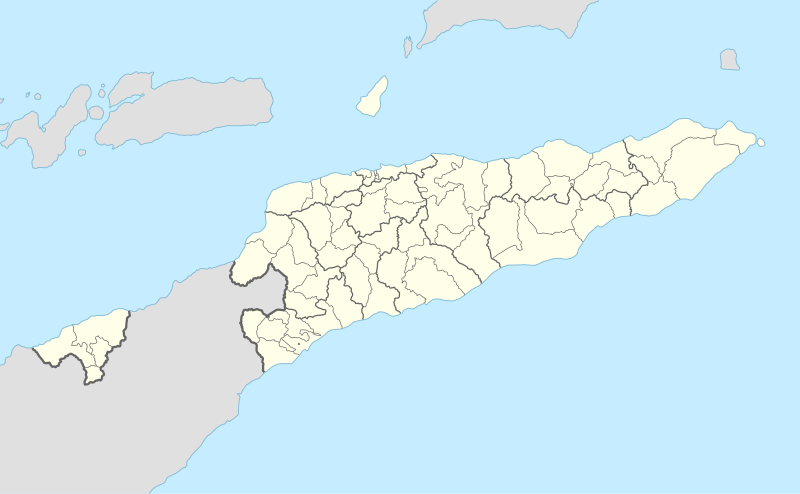

1 Fatumean , 2 Fatululic , 3 Maucatar , 4 Hatu-Builico , 5 Letefoho , 6 Ermera , 7 Railaco , 8 Liquiçá , 9 Dom Aleixo , 10 Vera Cruz , 11 Laulara , 12 Nain Feto , 13 Cristo Rei , 14 Manatuto , 15 Barique , 16 Uatucarbau
Organizational chart of the administration of the municipality and the administrative office
| President of the local government | |||||||||||||||||||||||||||||||||||||||||||||||||
|
Community secretary general duties |
Community Secretary Financial Management |
Community Secretary Local Development |
Advisory local council |
Coordinating local council |
|||||||||||||||||||||||||||||||||||||||||||||
| Municipal planning agency |
Municipal finance agency |
Technical support cabinet |
Municipal service for education |
Municipal service for registers, notaries and land registers |
Municipal Food Security Service |
||||||||||||||||||||||||||||||||||||||||||||
| Authority for Future Planning and Development |
School Development and Management Authority |
Registration and Notary Authority |
Food Security Supervision Authority |
||||||||||||||||||||||||||||||||||||||||||||||
| Authority for supervision and evaluation |
Education Program Management Authority |
Land and Property Authority |
Food Security Information and Promotion Agency |
||||||||||||||||||||||||||||||||||||||||||||||
| Municipal service for administration and personnel |
Municipal service for deployments |
Municipal service for property and logistics |
Municipal health service |
Municipal service for social measures |
Municipal service for water, sanitation and the environment |
||||||||||||||||||||||||||||||||||||||||||||
| Office for business hours, IT, minutes and archives |
Authority for provisioning processes |
Property Authority |
Authority for the development and management of the network of community health centers and posts |
Authority for the Promotion of Social Inclusion |
Authority for planning and development of the public supply network for water and basic sanitation |
||||||||||||||||||||||||||||||||||||||||||||
| Personnel authority | Authority for monitoring and carrying out public contracts |
Logistics Authority |
Authority for the Management of Health Programs |
Authority for the Promotion of Social Measures |
Environmental agency | ||||||||||||||||||||||||||||||||||||||||||||
| Authority for the management and control of the water network and basic sanitation |
|||||||||||||||||||||||||||||||||||||||||||||||||
| Municipal service for market management and tourism |
Municipal service for planning and integration |
Local service in support of NGOs and OCs |
Municipal agricultural service |
Municipal financial service | Municipal public works and transport service |
||||||||||||||||||||||||||||||||||||||||||||
Market Management Authority |
Municipal Investment Authority |
Authority for Assistance in the Sucos |
Agriculture Programs and Expansion Authority |
Budgetary Programs and Control Authority |
Authority for planning infrastructure and collective work equipment |
||||||||||||||||||||||||||||||||||||||||||||
| Authority Tourism |
Authority for the development of sucos |
Civil Society Support Authority |
Animal Husbandry Authority |
Authority for Accounting |
Authority for Management and Collective Work Tools |
||||||||||||||||||||||||||||||||||||||||||||
| Government agency and disbursements |
Authority for Organization and Management of Population Centers |
||||||||||||||||||||||||||||||||||||||||||||||||
Transportation Authority |
|||||||||||||||||||||||||||||||||||||||||||||||||
| Municipal service for natural disasters |
Municipal civil defense service |
Administration of the administrative office | |||||||||||||||||||||||||||||||||||||||||||||||
| Assembly of the administrative office | |||||||||||||||||||||||||||||||||||||||||||||||||
Prevention and Information Authority |
Civil Defense Equipment Planning and Management Authority |
||||||||||||||||||||||||||||||||||||||||||||||||
Emergency Operations Authority |
Authority for Prevention and Aid |
||||||||||||||||||||||||||||||||||||||||||||||||
| Local service for administration |
Local financial service |
Local service for community development |
Local service for planning and local development |
||||||||||||||||||||||||||||||||||||||||||||||
Sucos and Aldeias
| local community | Number of sucos in 2017 | Number of Aldeias in 2004 | Number of Aldeias in 2009 | Number of Aldeias 2017 |
|---|---|---|---|---|
| Aileu | 33 | 139 | 135 | 139 |
| Ainaro | 21st | 131 | 131 | 131 |
| Baucau | 59 | 286 | 281 | 281 |
| Bobonaro | 50 | 193 | 194 | 194 |
| Cova Lima | 30th | 147 | 148 | 148 |
| Dili | 36 | 241 | 241 | 241 |
| Ermera | 52 | 275 | 277 | 277 |
| Lautém | 34 | 151 | 151 | 151 |
| Liquiçá | 23 | 134 | 134 | 134 |
| Manatuto | 31 | 98 | 99 | 103 |
| Manufahi | 29 | 137 | 137 | 137 |
| Oe-Cusse Ambeno | 18th | 62 | 63 | 63 |
| Viqueque | 36 | 234 | 234 | 234 |

The sucos ( tetum suku ) are often equated with the term village . During the Portuguese colonial period, the sucos were called povoaçãos . In Dili they correspond to districts ( bairros ). Each sucos is headed by a suco chef ( chefe de suco , xefi suco ) and a suco council ( conselho de suco ), who are elected by the people.
Individual localities and districts of larger towns also have the status of an Aldeia (in English often equated with hamlet 'hamlet'), in which an Aldeia chef ( chefe de aldeia , xefi aldeia ) is elected. The first elections were held in 2004 and 2005, one after the other, in the individual districts at the time; the last elections were on October 9, 2009. The next elections will take place between September 15 and October 22, 2016 . The geographical boundaries of the Aldeias cannot be precisely defined, because in East Timor they are rather a social division that can perhaps best be equated with a “village community” or “neighborhood community”. During the 2010 and 2015 censuses, individual households were asked which Aldeia they felt they belonged to. However, mapping was not possible.
As of 2003, there were initially 496 sucos and 2336 aldeias. On July 14, 2004, the administrative borders were reorganized, after which there were only 442 sucos and 2228 aldeias. On September 15, 2009, the Aldeias were rearranged again, the number of Aldeias fell to 2225, and in 2017 the number of Sucos rose to 452 and Aldeias to 2233. In Aileu two sucos were added, in Dili five, in Manatuto two and in Viqueque one. The by-elections for the new sucos and aldeias took place in May. 42 of the sucos are classified as “ urban ”. 22 urban sucos alone are located in the municipality of Dili and form the state capital.
In terms of area, with 194.07 km² Muapitine ( Lospalos administrative office , Lautém municipality) is the largest Suco in East Timor. The smallest Suco is Gricenfor in Dili with 0.22 km². The urban Sucos Dilis have the highest population density. The front runner is Santa Cruz with 13,028.9 inhabitants / km². Fuiloro (administrative office Lospalos, municipality Lautém) has the largest population of the sucos outside Dilis with 16,701 inhabitants (2015).
In 2016, President Taur Matan Ruak signed a new “Suco Law” (Law 9/2016 of July 8, 2016). It defines the organization, duties and functions of the sucos and the tasks of the suco council. The procedure for the elections for the chefe de suco is also regulated. They take place every seven years; the incumbent can stand for re-election.
The Suco Council consists of the chefe de suco , the chefes de aldeia des Sucos, a female and a male delegate from each Aldeia, a female and a male youth representative and the Lian Nain .
The Aldeia assembly (assembleias de aldeia) is formed by all members of the village community over the age of 16. The chefes de aldeia are elected freely and secretly in the Aldeia assembly , as are the delegates for the Suco council. The Lian Nain and the youth representatives in the Suco Council are elected by the other newly elected members.
The sucos and aldeias are distributed among the individual communities as follows:
The following map shows the boundaries between 2003 and 2015.
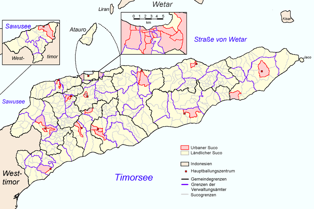

The borders of sucos East Timors 2015-2017. In pink, the sucos classified as urban
Further classifications of East Timor
For statistical purposes, the municipalities were grouped into regions. The regions are of no administrative importance.
- Region I: Baucau, Lautém, Viqueque
- Region II: Manatuto, Manufahi, Ainaro
- Region III: Dili, Aileu, Ermera
- Region IV: Bobonaro, Cova Lima, Liquiçá
- Special region (Region V): Oe-Cusse Ambeno

Historically and culturally, East Timor is divided into a western ( Loro Munu ) and an eastern region ( Loro Sae ). Before the colonization by Portugal and the Netherlands , the island of Timor was divided into three loose spheres of power, which were linked by a complicated system of alliances. The central part was dominated by the Wehale kingdom with laran , the spiritual center of the entire island. With the colonial division of the area of influence of Wehale, its eastern part with the eastern part of the island became the colony of Portuguese Timor and later became the state of East Timor. This division of the country cannot be traced back to the individual language groups, but has repeatedly led to conflicts in the history of the country, most recently with the unrest in East Timor in 2006 . The municipalities are assigned to the regions as follows:
- Loro Munu: Dili, Aileu, Ainaro, Manufahi, Ermera, Bobonaro, Cova Lima, Liquiçá, Oe-Cusse Ambeno.
- Loro Sae: Lautém, Baucau, Viqueque, Manatuto.
See also
Web links
- Division of East Timor under the Indonesian administration ( memento from September 29, 2007 in the Internet Archive )
- Law n. ° 6/2003 de 29 de Julho SOBRE A FIXAÇÃO DO NÚMERO DE SUCOS EM TERRITÓRIO NACIONAL ( Memento of September 29, 2007 on the Internet Archive )
- English version of the Diploma Ministerial n ° 6/2003 ( Memento of January 10, 2005 in the Internet Archive ) (PDF; 214 kB)
- Diploma Ministerial n. ° 9/2004 De 14 de Julho sobre a fixação de Aldeias para as eleições dos Chefes de Suco e Membros do Conselho de Suco (PDF; 1.60 MB)
- Jornal da Républica: Diploma Ministerial n. ° 199/09 (PDF; 315 kB)
- Jornal da Républica: Decreto-Lei N.º 4/2014 de 22 de Janeiro - Estatuto Orgânico das Estruturas de Pré-desconcentração Administrativa ( Memento of September 6, 2014 in the Internet Archive ) (PDF file)
- Jornal da República: Diploma Ministerial n. ° 16/2017 (PDF)
- Portal Municipal (English, Portuguese, tetum)
Individual evidence
- ↑ a b Direcção Nacional de Estatística: Census 2004 ( Memento from September 6, 2014 in the Internet Archive ), accessed on October 18, 2014
- ↑ a b Direcção Nacional de Estatística: 2010 Census Wall Chart (English) ( Memento from August 12, 2011 in the Internet Archive ) (PDF; 2.55 MB)
- ↑ a b c d Monika Schlicher: Portugal in East Timor. A critical examination of the Portuguese colonial history in East Timor from 1850 to 1912 . S. 134-136, Abera, Hamburg 1996, ISBN 3-931567-08-7 , ( Abera Network Asia-Pacific 4), (at the same time: Heidelberg, Univ., Diss., 1994).
- ^ Geoffrey C. Gunn: History of Timor , available from the Centro de Estudos sobre África, Ásia e América Latina , CEsA of the TU Lisbon (PDF file; 805 kB).
- ↑ a b c 150 Anos da criação de distritos em Timor
- ↑ a b c d e f Government of Timor-Leste: Administrative Division (English)
- ↑ Campeào_das_Provincias: Timor , September 23, 1908 , accessed January 27, 2020.
- ↑ Lúcio Manuel Gomes de Sousa: O bazar colonial no Timor Português: a submissão dos "comerciantes selvagens" , p. 8 , accessed on January 27, 2020.
- ↑ Schlicher pp. 272-273.
- ^ João Soares: Novo Atlas Escolar Português , 5th updated edition, Lisboa 1954
- ^ Cova Lima District Development Plan 2002/2003. ( Memento of October 14, 2013 in the Internet Archive ) (English; PDF file; 2.24 MB)
- ^ Ministry of State Administration and Territorial Management : Plano Estratégico de Ainaro , January 8, 2016 (tetum), p. 17 , accessed on May 7, 2016.
- ↑ Patricia Thatcher: The Timor-Born in Exile in Australia , p. 50, Master's Thesis, Department of Anthropology and Sociology, Monash University, Melbourne 1992.
- ↑ Laura Suzanne Meitzner Yoder: Custom, Codification, Collaboration: Integrating the Legacies of Land and Forest Authorities in Oecusse Enclave, East Timor , p. 89 ( Memento of March 7, 2007 in the Internet Archive ), Yale University 2005 (PDF; 1, 46 MB)
- ↑ Susana Barnes: Origins, Precedence and Social Order in the Domain of Ina Ama Beli Darlari , In: Land and life in Timor-Leste, p. 24 .
- ↑ "Part 4: Regime of Occupation" (PDF; 563 kB) from the "Chega!" Report of the CAVR (English)
- ↑ a b c Jornal da República : Diploma Ministerial no 24/2014 de 24 de Julho - Orgânica dos Postos Administrativos ( Memento of March 4, 2016 in the Internet Archive )
- ↑ Ministério da Administração Estatal: Município de Aileu ( Memento of June 20, 2016 in the Internet Archive ) as an example, accessed on November 9, 2015.
- ^ Ministry of State Administration and Territorial Management : Plano Estratégico de Ainaro , January 8, 2016 (tetum), p. 16 , accessed on May 7, 2016.
- ↑ a b National Statistical Office of East Timor DNE: Suco Report Volume 4 (English) ( Memento of 9 April 2015, Internet Archive ) (PDF 9.35 MB).
- ↑ cf. Maps in Direcção-Geral de Estatística: TIMOR-LESTE EM NÚMEROS / TIMOR-LESTE IN FIGURES 2014 and Population and Housing Census 2015 Preliminary Results , both accessed on July 30, 2016.
- ↑ a b Direcção-Geral de Estatística: DILI EM NÚMEROS 2016 , p. 3, accessed on March 8, 2019.
- ↑ Jornal da República: Diploma Ministerial n ° 16/2017 , with corrections dated May 9, 2017 , accessed on March 12, 2019.
- ↑ Jornal da República: DECRETO LEI No. 5/2015 de 22 de Janeiro - Estatuto da Região Administrativa Especial de Oe-Cusse Ambeno . ( Memento of March 4, 2016 in the Internet Archive ), accessed on November 9, 2015.
- ^ Constitution of East Timor (Portuguese), accessed May 29, 2015.
- ^ Laura Suzanne Meitzner Yoder: Custom, Codification, Collaboration: Integrating the Legacies of Land and Forest Authorities in Oecusse Enclave, East Timor. P. 25, Dissertation, Yale University, 2005 ( PDF file; 1.46 MB ( memento of March 7, 2007 in the Internet Archive )).
- ^ Timor-Leste Ministry of Finance: Oé-Cusse: the beginning of a better future for Timor-Leste , accessed on February 3, 2015.
- ^ I Constitutional Government. In: Timor-Leste government website. Retrieved July 18, 2014 .
- ^ Arsénio Bano elected Vice President of FRETILIN. (PDF; 68 kB) FRETILIN, July 30, 2007, accessed on July 18, 2014 (English).
- ↑ Direcção Nacional de Estatística: Census 2004 ( Memento from September 6, 2014 in the Internet Archive ), accessed on October 18, 2014.
- ↑ a b c d e Direcção-Geral de Estatística : Results of the 2015 census , accessed on November 23, 2016.
- ^ Ministry of State Administration and Territorial Management: Country Profile - Timor-Leste , October 2008 , accessed October 25, 2015.
- ↑ Government Page: Council of Ministers Approves Law on Local Governance Proposals. ( Memento from April 8, 2015 in the Internet Archive )
- ^ Jornal da Républica: Law No. 11/2009 of 7 October TERRITORIAL ADMINISTRATIVE DIVISION ( Memento from March 4, 2016 in the Internet Archive ), accessed on October 25, 2015.
- ↑ a b Terry Russell: Decentralization and rural development in Timor-Leste , April 3, 2015 East Timor Forum , accessed on April 7, 2015.
- ↑ Jornal da República: Despacho Nº03 / M-MAE / IX / 2016 , accessed on January 20, 2018.
- ↑ Facebook page of the State Secretariat for the decentralization of administration: Organograma das Autoridades Municipais. , October 20, 2016 , accessed October 21, 2016.
- ↑ Direcção-Geral de Estatística: Timor-Leste in Number 2017 , accessed on March 8, 2019.
- ↑ Independente: Four New Villages For Dili , April 17, 2017, accessed March 9, 2019.
- ↑ Jornal da República : Lei 9/2016 Lei dos Sucos , (Portuguese), accessed on September 10, 2016.
- ^ A b President's website: PRESS RELEASE: HE the President of the Republic, Taur Matan Ruak, Enacts the Suco Law , July 14, 2016 , accessed July 20, 2016.
- ↑ a b c SAPO: Setembro e outubro com eleições de líderes locais e tradicionais em Timor-Leste , September 2, 2016 , accessed on September 2, 2016.
Afghanistan | Egypt | Armenia | Azerbaijan | Bahrain | Bangladesh | Bhutan | Brunei | China | Georgia | India | Indonesia | Iraq | Iran | Israel | Japan | Yemen | Jordan | Cambodia | Kazakhstan | Qatar | Kyrgyzstan | Korea, North Korea | Korea, South Korea | Kuwait | Laos | Lebanon | Malaysia | Maldives | Mongolia | Myanmar | Nepal | Oman | East Timor | Pakistan | Philippines | Russia | Saudi Arabia | Singapore | Sri Lanka | Syria | Tajikistan | Thailand | Turkmenistan | Turkey | Uzbekistan | United Arab Emirates | Vietnam | Cyprus
Administrative division of the States of:
Africa |
Asia |
Australia and Oceania |
Europe |
North and South America