
Fahiria
| Fahiria | |||

|
|||

|
|||
| Data | |||
| surface | 33.03 km² | ||
| population | 1,823 (2015) | ||
| Chefe de Suco | Alberto Loutes (election 2016) |
||
| Aldeias | Population (2015) | ||
| Daulala | 243 | ||
| Fahiria | 134 | ||
| Fatubuti | 212 | ||
| Manulete | 292 | ||
| Sarin | 560 | ||
| Sidole | 382 | ||
|
|||

Fahiria is an East Timorese Suco and Aldeia in Administrative Office Aileu ( Office of Administration Aileu ).
geography
| Fahiria | ||
| places | position | height |
| Sarin | 8 ° 45 ′ S , 125 ° 34 ′ E | 935 m |
| Sidole | 8 ° 43 ' S , 125 ° 35' E | 1162 m |
Before the 2015 territorial reform, Fahiria had an area of 43.77 km². Now it is 33.03 km². The Suco Fahiria is located in the east of the administrative office of Aileu. To the northwest lie the sucos Saboria , Aissirimou and Seloi Malere , to the west Liurai and southwest Bandudato . In the northeast, Fahiria borders on the administrative office of Remexio with its Suco Fahisoi , in the east on the administrative office of Lequidoe with its sucos Fahisoi , Manucassa , Namolesso and Betulau, and in the south on the administrative office of Maubisse, which belongs to the municipality of Ainaro, with its sucos Maulau and Fatubessi . Part of the border with Saboria is followed by the Huituco River , which, together with the Berecali coming from the north, forms the Mumdonihun further west, which forms the border with Aissirimou, Seloi Malere and Liurai, while it swings to the south. From the west comes Manolane and finally forms the Mumdonihun the Monofonihun , followed by a long stretch the border with Bandudato before he crosses Fahiria, the southern border Mancassas follows Fahiria, later as a border river between Fahiria and Namolesso Manufonihun is finally Fahiria according East leaves. The daisoli forms the entire border to Maubisse. All rivers are part of the Northern Laclós system .
While the municipality capital Aileu Vila lies on the other side of the Mumdonihun , there are only a few small settlements in Suco Fahiria. The village of Sidole is on the south bank of the Huituco . Near the confluence of Mumdonihun and Manolane the place is sarin in the far west of the Sucos. There is a primary school in Sidole.
In the Suco there are the six Aldeias Daulala , Fahiria , Fatubuti , Manulete , Sarin and Sidole .
Residents
1823 inhabitants live in the Suco (2015), 962 of them are men and 861 women. The population density is 55.2 inhabitants / km². There are 301 households in the Suco. Over 66% of the population name Tetum Prasa as their mother tongue. Over 31% speak Mambai , small minorities speak Bunak , Tetum Terik , Galoli or Habun .
history
The residents of Fahiria were forcibly moved to the city of Aileu on September 4, 1999, during Operation Donner by the AHI militia . The houses in Fahiria were burned down and the cattle killed.
politics
In the 2004/2005 elections , Luís Farias Araújo was elected Chefe de Suco. In the 2009 elections won Luís Naimau and 2016 Alberto Loutes .
Web links
- Results of the 2010 census for the Suco Fahiria ( tetum ; PDF; 8.3 MB)
- Results of the 2015 census for the Suco Fahiria (tetum; PDF)
- Seeds of Life: Suco information sheets Aileu Vila (tetum)
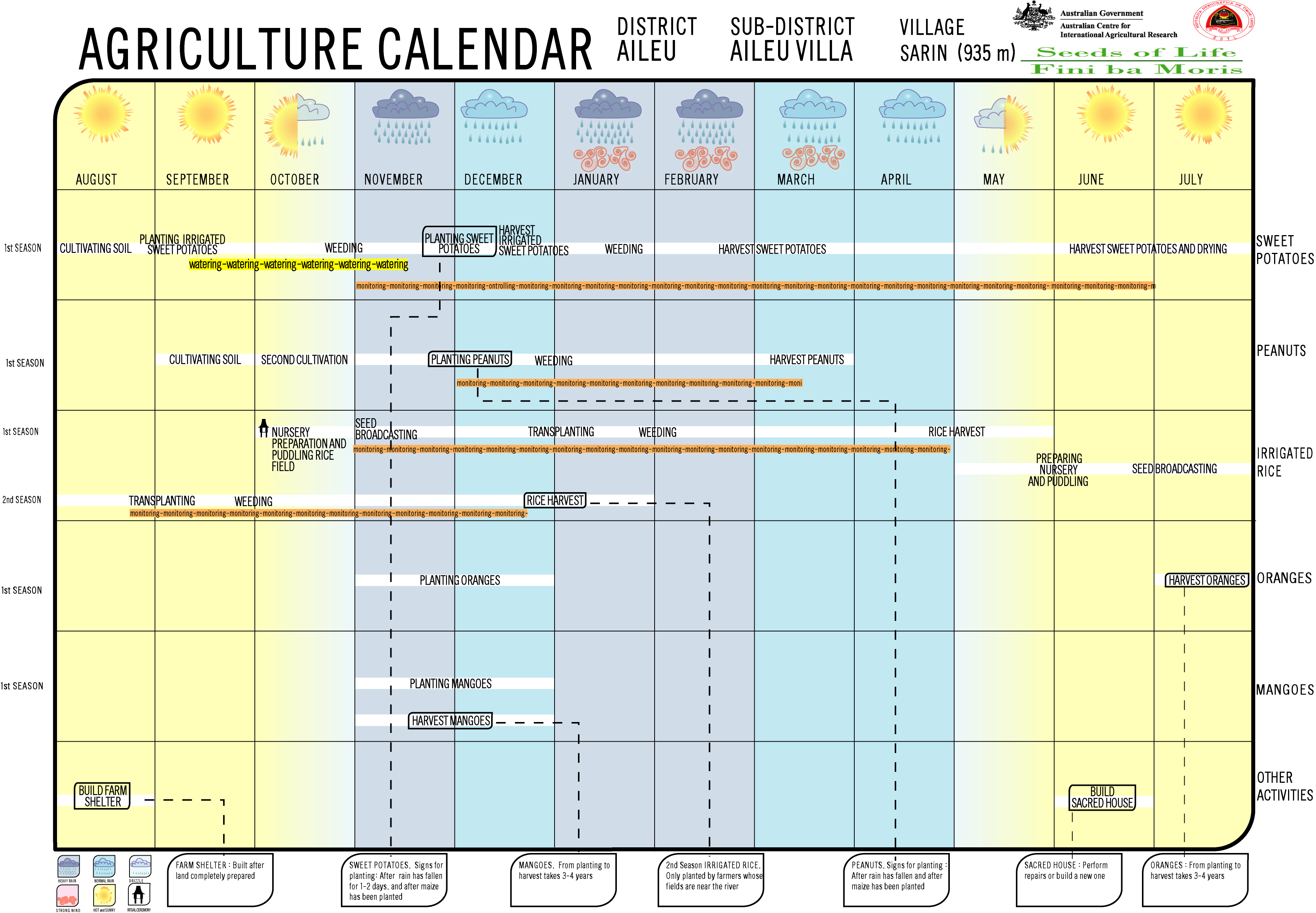
- Seeds of Life: Agriculture Calendar: Sarin (English)
Individual evidence
- ↑ a b c d Direcção-Geral de Estatística : Results of the 2015 census , accessed on November 23, 2016.
- ↑ Fallingrain.com: Directory of Cities, Towns, and Regions in East Timor
- ↑ Direcção Nacional de Estatística: Population Distribution by Administrative Areas Volume 2 English ( Memento from January 5, 2017 in the Internet Archive ) (Census 2010; PDF; 22.6 MB)
- ^ Timor-Leste GIS-Portal ( Memento from June 30, 2007 in the Internet Archive )
- ↑ UNMIT: Timor-Leste District Atlas version 02, August 2008 ( Memento from December 3, 2011 in the Internet Archive ) (PDF; 530 kB)
- ↑ Jornal da Républica with the Diploma Ministerial n. 199/09 ( Memento of February 3, 2010 in the Internet Archive ) (Portuguese; PDF; 323 kB)
- ↑ Results of the 2010 census for the Suco Fahiria ( tetum ; PDF; 8.3 MB)
- ↑ "Chapter 7.3 Forced Displacement and Famine" ( Memento of November 28, 2015 in the Internet Archive ) (PDF; 1.3 MB) from the "Chega!" Report of the CAVR (English)
- ↑ Secretariado Técnico de Administração Eleitoral STAE: Eleições para Liderança Comunitária 2004/2005 - Resultados ( Memento of August 4, 2010 in the Internet Archive )
- ↑ Secretariado Técnico de Administração Eleitoral STAE: Eleições para Liderança Comunitária 2009 - Resultados ( Memento of August 4, 2010 in the Internet Archive )
- ↑ Jornal da República: Lista Naran Xefe Suku Eleito 2016 , accessed on June 17, 2020.
Aissirimou | Bandudato | Fahiria | Fatubossa | Hoholau | Lahae | Lausi | Lequitura | Liurai | Saboria | Seloi Craic | Seloi Paintings
![]() Map with all coordinates: OSM | WikiMap
Map with all coordinates: OSM | WikiMap
The administrative borders within East Timor changed in 2015. This article must therefore be checked and updated if necessary. See New Administrative Boundaries .