Northern Lacló
|
Northern Lacló Rio Lacló do Norte ( pt ), Lacló, Mota Laclo ( tet. ), Mota Lakló |
||
|
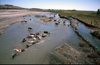
Water buffalo in Northern Laclo |
||
| Data | ||
| location | East Timor , Manatuto Municipality | |
| River system | Northern Lacló | |
| Drain over | Wetar Strait → Pacific Ocean | |
| source | Bericute pond | |
| muzzle | at Manatuto coordinates: 8 ° 29 ′ 56 ″ S , 126 ° 0 ′ 11 ″ E 8 ° 29 ′ 56 ″ S , 126 ° 0 ′ 11 ″ E
|
|
| Small towns | Manatuto | |
The Northern Lacló , also Lacló , Mota Laclo and Mota Lakló ( Tetum : Ribeira de Lacló , Portuguese : Ribeira de Lacló do Norte or Rio Lacló do Norte), is a river that forms the largest hydrographic basin in East Timor .
course

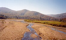
The Northern Lacló and its tributaries reach a total length of 485 km. Along with the Lóis , it is one of the few rivers that carry water all year round in the northern part of the island, as they are fed from the south.
The Northern Lacló rises from the Bericute pond , south of Dili , then flows northeast through the Laclo administrative office , where several rivers flow into it and reaches the Timorese north coast between the Ponta de Subaio and the Baía de Lanessana near Manatuto in the municipality of the same name .
bridges

In the 1960s, the Portuguese built a bridge over the Lacló for the first time. But only shortly after the inauguration it was swept away. The architect was fired, but found a job with the company that was tasked with rebuilding the bridge. After it was rebuilt a few years later, it collapsed again.
Trivia
There is no direct connection to the southern Lacló , which flows south from the central mountains into the Timor Sea .
See also
Web links
Individual evidence
- ^ Government of Timor-Leste: Administrative Division (English)
- ↑ José Ramos-Horta: Funu. East Timor's struggle for freedom is not over! Ahriman-Verlag, Freiburg 1997, ISBN 3-89484-556-2
