
Aileu
| Aileu | |||
|---|---|---|---|
|
|||
| Coordinates | 8 ° 43 ′ S , 125 ° 34 ′ E | ||

|
|||
| Basic data | |||
| Country | East Timor | ||
| Aileu | |||
| Administrative office | Aileu | ||
| ISO 3166-2 | TL-AL | ||
| Suco | Seloi Malere , Liurai | ||
| Residents | 2927 (2010) | ||
 Aileu Vila
|
|||

Aileu ( Aileu Vila ) is a city in East Timor . It is the capital of the administrative office of Aileu and the parent municipality of Aileu .
Place name

Aileu means "curved tree" in Mambai . In 1936 Aileu was renamed by the Portuguese, after the Portuguese President António Óscar de Fragoso Carmona , to Vila General Carmona . But the name did not catch on and a few years after the Second World War , the old name was reverted to.
Geography and inhabitants
Aileu lies on the Mantane and Mumdonihun rivers , on the road that connects Dili across the island with Betano on the south coast. The center of the city is in the Suco Seloi Malere ( Malere ), about 30 km south of the state capital Dili at an altitude of 913 m . The region is very mountainous, which is why the road from Aileu to Dili is 47 km long. The settlement extends south into the Suco Liurai .
Aileu has 2927 inhabitants (as of 2010). Almost the entire population in Aileu speaks Tetum Prasa as their mother tongue , only a small minority uses Mambai .
Infrastructure and architecture

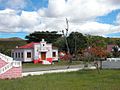
The city of Aileu has a primary school ( Escola Primaria No. 1 ), a pre-secondary school, a secondary school, a helipad, a police station and a community health center. In the center of the village is the old administration building from the Portuguese time. A sports field was laid out behind it. Opposite is the memorial for the massacre in Aileu in 1942 (see Battle of Timor ). Outside, about one kilometer from the integration monument, there is a Lourdes grotto ( Gruta ) for Our Lady of Lourdes on the road to Dili .
In the city center, not far from the bus station, the ruins of the Chinese school still rise up. On the main street of Aileu, near the school, in front of which a model of a hut in the traditional Mambai style was built, you can still see the ruins of houses built during the Portuguese colonial era. The Catholic parish church Igreja São Pedro e São Paulo , also renovated, rises on a hill just outside the center.
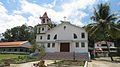
Catholic Church Igreja São Pedro e São Paulo
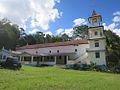
Catholic Church Igreja São Pedro e São Paulo

Catholic Church Igreja São Pedro e São Paulo

The local center at the hospital
The colonial administrative seat of Aileus

Gruta da Nossa Senhora Lurdes de Aileu

School center


history


In 1903 an uprising against the colonial rulers in Aileu failed. In January 1912 the place served as the base of the Portuguese in the suppression of the Manufahi rebellion .
Between 1942 and 1945 , the Japanese occupied Portuguese Timor . On August 20, 1942, Aileu was occupied by 300 Colunas Negras , Timorese allies of the Japanese invaders. On August 31, they killed five Portuguese soldiers and four other Portuguese officials and missionaries. Japan blamed this, as well as other incidents, on "a group of West Timorese " who wanted to settle in the east and were mistreated by the Portuguese.
Aileu was already a stronghold of FRETILIN during the civil war in East Timor in 1975 . This is where the leadership retreated after the Indonesian invasion of Dili , until Aileu was overrun by the Indonesians on December 31, 1975. FRETILIN had previously executed around 22 prisoners from the civil war.
At the end of 1979 there was an Indonesian camp in Aileu for East Timorese who were supposed to be relocated by the occupiers for better control. In early September 1999, residents of various sucos in the region were evicted from their homes by the AHI militia ( Aku Hidup dengan Integrasi / Indonesia ) during the Indonesian Operation Donner . The Suco Seloi Malere was systematically destroyed on September 6th and the houses burned down.
At the end of 1999 there were temporary plans to make Aileu the new capital of an independent East Timor. But these were rejected again.
Fighters from the East Timorese resistance movement FALINTIL were barracked in Aileu from 2000 to February 2001 after the United Nations took over administration of the country. Later, 600 of the fighters began training here to become soldiers of the new East Timorese Defense Forces .
Sons and daughters
- Alberto Ricardo da Silva (1943–2015), bishop
Town twinning
-
 City of Moreland , Australia
Web links
Individual evidence
- ↑ Jornal da República : Diploma Ministerial no 24/2014 de 24 de Julho - Orgânica dos Postos Administrativos ( Memento of March 4, 2016 in the Internet Archive )
- ^ Timor-Leste GIS-Portal ( Memento from June 30, 2007 in the Internet Archive )
- ↑ Geoffrey Hull : The placenames of East Timor , in: Placenames Australia (ANPS): Newsletter of the Australian National Placenames Survey, June 2006, pp. 6 & 7, ( Memento of February 14, 2017 in the Internet Archive ). September 2014.
- ^ Ministry of State Administration and Territorial Management: District profile summary - Aileu ( Memento of March 18, 2012 in the Internet Archive )
- ↑ Direcção Nacional de Estatística: Preliminary Result of Census 2010 English ( Memento from September 6, 2014 in the Internet Archive ) (PDF; 3.0 MB)
- ↑ Results of the 2010 census for the Suco Seloi Malere ( tetum ; PDF; 8.3 MB)
- ↑ List of polling stations for the parliamentary elections in East Timor 2007 (PDF file; 118 kB)
- ↑ UNMIT: Timor-Leste District Atlas version 02, August 2008 ( Memento from December 3, 2011 in the Internet Archive ) (PDF; 530 kB)
- ↑ Archdiocese Dili: Paroaquias , accessed on 23 June 2020th
- ^ A b Geoffrey C. Gunn: History of Timor. ( Memento of the original from March 24, 2009 in the Internet Archive ) Info: The archive link was inserted automatically and has not yet been checked. Please check the original and archive link according to the instructions and then remove this notice. Technical University of Lisbon (PDF file; 805 kB)
- ↑ Kisho Tsuchiya: Indigenization of the Pacific War in Timor Island: A Multi-language Study of its Contexts and Impact , p. 13, Journal War & Society, Vol. 38, No. February 1, 2018.
- ↑ "Part 3: The History of the Conflict" (PDF; 1.4 MB) from the "Chega!" Report of the CAVR (English)
- ↑ a b "Chapter 7.3 Forced Displacement and Famine" ( Memento from November 28, 2015 in the Internet Archive ) (PDF; 1.2 MB) from the "Chega!" Report of the CAVR (English)
- ^ The Permanent Committee on Geographical Names: East Timor - Geographical names against a volatile background, 1999 ( Memento of February 9, 2013 in the Internet Archive ) (PDF; 63 kB)
- ↑ Website of the Ministry of Foreign Affairs of East Timor ( Memento from May 15, 2013 in the Internet Archive )
The administrative borders within East Timor changed in 2015. This article must therefore be checked and updated if necessary. See New Administrative Boundaries .