
Squire head
| Squire head | ||
|---|---|---|
 Just head from Kugelhorn seen from |
||
| height | 2071 m above sea level A. | |
| location | Border Bavaria , Germany / Tyrol , Austria | |
| Mountains | Vilsalpseeberge , Allgäu Alps | |
| Dominance | 0.5 km → Kugelhorn | |
| Notch height | 35 m ↓ notch to the Kugelhorn | |
| Coordinates | 47 ° 26 '57 " N , 10 ° 28' 13" E | |
|
||
| rock | Flysch | |

The Knappenkopf is a 2071 m above sea level. A. high mountain peak in the Allgäu Alps , over which the border between Germany and Austria runs.
Location and surroundings
The Knappenkopf is a minor summit south of the Kugelhorn (2126 m). It rises from the grass ridge that connects the Kugelhorn over the Kirchendachsattel (1927 m) with the Kälbelespitze (2135 m) in the south. In the southwest is the Schrecksee (1813 m), northeast of the Vilsalpsee (1165 m) and in the east of the Alplsee (1620 m).
The closest places are Hinterstein in the northwest and Tannheim in the northeast.
Origin of name
The Knappenkopf was first mentioned in 1800 in a description of the Taufersalpe in the Taufersbachtal northwest below the summit: in which gknaben heads . 1803 was mentioned again in an alpine description in Gnappen heads . The origin of the name is still unclear. There is no evidence of ore mining in the area.
Ascent
The Knappenkopf is mostly crossed in connection with the Kugelhorn. The access is from the southern Kirchdachspitze saddle on a weak path trail over a steep grassy ridge and a brief Gratschneide that surefootedness requires. The Jubiläumsweg runs west of the summit , from which the summit can also be reached shortly.
gallery

From the north
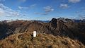
Boundary stone at the summit

Above the Schrecksee

Rauhhornzug from Vilsalpsee


Literature and map
- Dieter Seibert: Alpine Club Guide alpine - Allgäu Alps and Ammergau Alps . 17th edition. Bergverlag Rother, Munich 2008, ISBN 978-3-7633-1126-2
- Topographic map 1: 50,000 Allgäu Alps, Bavarian Land Survey Office, Munich. ISBN 978-3860380116
Web links
Individual evidence
- ^ Thaddäus Steiner : Allgäu mountain names . 2nd Edition. Kunstverlag Josef Fink, Lindenberg 2008, ISBN 978-3-8987-0389-5 (p. 119 f).