
Kugelhorn
| Kugelhorn | ||
|---|---|---|
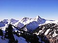
 Kugelhorn with Kälbelespitze and Schrecksee |
||
| height | 2126 m | |
| location | Border Bavaria , Germany / Tyrol , Austria | |
| Mountains | Vilsalpseeberge , Allgäu Alps | |
| Dominance | 0.9 km → Rauhhorn | |
| Notch height | 161 m ↓ rear sheep bath | |
| Coordinates | 47 ° 26 '55 " N , 10 ° 28' 14" E | |
|
||
| First ascent | local people | |

The Kugelhorn is a 2,126 meter (according to German measurements: 2125 m ) high grass mountain in the Allgäu Alps in the ridge that runs south from the Rauhhorn . The Jubiläumsweg runs right below the summit of the Kugelhorn on the north and west side . From here, the summit can be reached easily over steep grass and craggy slopes (sure-footedness required).
photos

Summit construction

Kugelhorn, Rauhhorn and Vilsalpsee
View from the Neunerköpfle to the Kugelhorn, Rauhhorn and Gaishorn.


literature
- Thaddäus Steiner : Allgäu mountain names . Kunstverlag Josef Fink, Lindenberg 2007, ISBN 978-3-89870-389-5 .
- Ernst Zettler, Heinz Groth: Alpine Club Guide Allgäu Alps . 12th edition. Bergverlag Rudolf Rother, Munich 1984, ISBN 3-7633-1111-4 .
Web links
Commons : Kugelhorn - Collection of images, videos and audio files
Individual evidence
- ↑ Bavarian Surveying Administration : BayernViewer 2.0 ( Memento of the original from May 2, 2014 in the Internet Archive ) Info: The archive link was inserted automatically and has not yet been checked. Please check the original and archive link according to the instructions and then remove this notice. . Retrieved January 13, 2011.