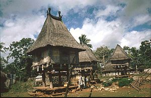
Bauro
| Bauro | ||

|
||

|
||
| Data | ||
| surface | 71.46 km² | |
| population | 2,432 (2015) | |
| Chefe de Suco | Sidalio Freitas (election 2009) |
|
| Aldeias | Population (2015) | |
| Bauro | 740 | |
| Iralafai | 489 | |
| Luarai | 544 | |
| Sepelata | 287 | |
| Somotcho | 372 | |
|
|
||
Bauro is an East Timorese Suco in the administrative office of Lospalos ( Lautém municipality ). The place Bauro is across the border in Suco Fuiloro .
geography
| Bauro | ||
| places | position | height |
| Assalaino | 8 ° 26 ' S , 127 ° 3' E | 397 m |
| Iralafai | 8 ° 26 ' S , 127 ° 2' E | 406 m |
| Lurarai | 8 ° 26 ' S , 127 ° 2' E | 403 m |
| Motara | 8 ° 28 ′ S , 127 ° 2 ′ E | ? |
| Somotcho | 8 ° 26 ' S , 127 ° 3' E | 402 m |
| Sepelata | 8 ° 26 ' S , 127 ° 3' E | 402 m |
| Trisula | 8 ° 26 ' S , 127 ° 1' E | 400 m |

Before the 2015 regional reform, Bauro had an area of 99.33 km². Now there are 71.46 km². The Suco is located in the northwest of the administrative office of Lospalos. In the south is the Suco Muapitine , in the southwest Fuiloro, west of the Suco Raça , to the north is the Lautém administrative office with its Sucos Parlamento and Com and in the east the Tutuala administrative office with the Suco Mehara . In the southeast, part of the Lagoa Ira Lalaro , the largest lake in East Timor, extends into the Suco during the rainy season . There is a small underground lake in the Fatuk Kuak cave .
In the north-west of Bauro, the villages Trisula and Assalaino are in the immediate vicinity of Bauro . From here a track leads through the north of the Sucos in the direction of Tutuala, where the villages Luarai , Iralafai , Sepelata and Somotcho ( Samocho ) are located. After Motara in southwestern only a small road leads. Motara, Somotcho and Iralafai each have a primary school.
In Bauro are the five Aldeias Bauro , Iralafai , Luarai , Sepelata and Somotcho .
Residents

2432 people (2015) live in the Suco, of which 1206 are men and 1226 women. The population density is 34.0 inhabitants / km². There are 471 households in the Suco. Almost 91% of the population name Fataluku as their mother tongue. Over 9% speak Tetum Prasa .
history
In Trisula, the Japanese built a prison that was later used by the Portuguese .
politics
In the 2004/2005 elections , Agusto da Silva was elected Chefe de Suco. In the 2009 elections , Sidalio Freitas won .
Personalities
- José da Costa (1927–1980), freedom fighter
- Horácio Marques (* 1962), General Director of the Arquivo Nacional de Timor-Leste
- Juventina Napoleão (* 1988 in Assalaino), marathon runner
Web links
- Results of the 2010 census for the Suco Bauro ( tetum ; PDF; 8.6 MB)
- Results of the 2015 census for the Suco Bauro (tetum; PDF)
- Seeds of Life: Suco information sheets Lospalos (tetum)
Individual evidence
- ↑ a b c d Direcção-Geral de Estatística : Results of the 2015 census , accessed on November 23, 2016.
- ↑ Fallingrain.com: Directory of Cities, Towns, and Regions in East Timor
- ↑ Direcção Nacional de Estatística: Population Distribution by Administrative Areas Volume 2 English ( Memento from January 5, 2017 in the Internet Archive ) (Census 2010; PDF; 22.6 MB)
- ↑ Timor Leste iha Mundu: Piscina Natural iha Fatuk Kuak, Lospalos, Suku Bauro Ira Quru, Município Lautem , March 31, 2019 , accessed on June 22, 2019.
- ^ Timor-Leste GIS-Portal ( Memento from June 30, 2007 in the Internet Archive )
- ↑ UNMIT card from August 2008 ( Memento from December 3, 2011 in the Internet Archive ) (PDF; 389 kB)
- ↑ Jornal da Républica with the Diploma Ministerial n. 199/09 ( Memento of February 3, 2010 in the Internet Archive ) (Portuguese; PDF; 323 kB)
- ↑ Results of the 2010 census for the Suco Bauro ( tetum ; PDF; 8.6 MB)
- ↑ Lautém District Development Plan 2002/2003, p. 5 ( Memento of February 3, 2011 in the Internet Archive ) (English; PDF file; 1.97 MB)
- ↑ Secretariado Técnico de Administração Eleitoral STAE: Eleições para Liderança Comunitária 2004/2005 - Resultados ( Memento of August 4, 2010 in the Internet Archive )
- ↑ Secretariado Técnico de Administração Eleitoral STAE: Eleições para Liderança Comunitária 2009 - Resultados ( Memento of August 4, 2010 in the Internet Archive )

