
Lore I.
| Lore I. | |||

|
|||

|
|||
| Data | |||
| surface | 133.27 km² | ||
| population | 2,589 (2015) | ||
| Chefe de Suco | Mateus Fernandes Sequeira (election 2009) |
||
| Aldeias | Population (2015) | ||
| Horolata | 403 | ||
| Maluro | 351 | ||
| Otcho-Tchau | 424 | ||
| Tchai | 1,186 | ||
| Titilari | 26th | ||
| Vailana | 199 | ||
|
|||

Lore ( Loré ) is a village and Suco in the far east of East Timor . They are part of the Lospalos Administrative Office ( Lautém municipality ). In the Portuguese colonial times the place was called Silvícola .
The place
The village of Lore is located in Suco Lore I near the coast of the Timor Sea at an altitude of 147 m . This is where the sucos's only medical supply post is located. Not far from Lore is a helipad, near Cape Ponta de Lore , in front of which there is one of the few anchorages in the country for larger ships.

Distillation of schnapps in the village of Lore
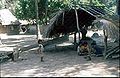
The fermented sugar juice is evaporated in the round container and passed through the long tube into a bottle.
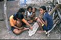
The children have to be careful that the fire for the schnapps distillation does not go out. You pass the time with games.


The Suco
| Lore I. | ||
| places | position | height |
| Horolata | 8 ° 39 ′ S , 127 ° 1 ′ E | 147 m |
| Ilicoa | 8 ° 37 ' S , 127 ° 3' E | 96 m |
| Lore | 8 ° 39 ′ S , 127 ° 1 ′ E | 147 m |
| Lori | 8 ° 40 ′ S , 127 ° 2 ′ E | 30 m |
| Maluro | 8 ° 38 ' S , 127 ° 1' E | 185 m |
| Nualata | 8 ° 38 ′ S , 126 ° 59 ′ E | 306 m |
| Otcho-Tchau | 8 ° 38 ' S , 127 ° 1' E | 236 m |
| Paio | 8 ° 35 ' S , 127 ° 6' E | 3 m |
| Raca | 8 ° 36 ' S , 127 ° 1' E | 232 m |
| Tchai | 8 ° 36 ' S , 127 ° 1' E | 232 m |
| Vailana | 8 ° 39 ′ S , 127 ° 1 ′ E | 65 m |


Lore I has 2589 inhabitants (2015), of which 1248 are men and 1341 women. The population density is 19.4 inhabitants / km². There are 541 households in the Suco. Almost 96% of the population name Fataluku as their mother tongue. Almost 3% speak Tetum Prasa , minorities Tetum Terik or Dadu'a .
Before the 2015 regional reform, Lore I had an area of 133.77 km². Now there are 133.27 km². A poorly developed road from the coast of the Timor Sea connects Aldeia Lori with the municipal capital Lospalos. Most of the other places in sucos are on this street or on a few small side streets. The river Tchino , which forms the border with Lore II , Souro and Cacavei in the north, is spanned with a bridge. It is also called Tehino in its upper reaches . Its source is located in the border area between Lore I and Lore II. The Tchino opens into the Namaluto , the West boundary of the Sucos to the administrative office iliomar subdistrict with its Suco Fuat and after the inflow of the Irarau to Suco iliomar subdistrict I represents. A small road also leads from Lori to Iliomar, but it is not passable when it rains heavily. To the northeast of Lore I, across the Urunami River , lies the Suco Muapitine . A coastal plain extends to the west from Lore, initially narrow to Viqueque , then wider to the border with Indonesia . The area is characterized by coastal dry forests, mangrove forests and coastal grassland. Since the region is far away from the population centers of East Timor and relatively poorly accessible, the nature here is still largely untouched. The Ira Lafai spring is located in the west of Sucos .
A little north of the Ponta de Lore on the coast is Lori with one of three primary schools of Sucos. The second is in Maluro , north of Lore and a little further near Raca, the third. The villages of Vailana and Horolata ( Harolata ) are located near Lore . To the west of Maluro are the villages of Otcho-Tchau ( Ochochau , Otxo-Txa'u ) and Nualata and north of Raca Tchai ( Chai ) and Ilicoa (north of Raca). In the extreme east of Lore I lies the small town of Paio on the coast between the Urunami and Lapalapa rivers .
The place name Otcho-Tchau means "bracelet" and "head", here meaning "owner of bracelets". Traditionally, only residents of the region wore bracelets in the region.
In Lore I there are the six Aldeias Horolata , Maluro , Otcho-Tchau , Tchai , Titilari and Vailana .
An area around Lore with 10,906 hectares with its forest and the surrounding rice fields has been designated as an Important Bird Area by BirdLife International . Here you can still find teak , sandalwood and bamboo , in which at least 24 protected bird species live, such as the green Timor pigeon or the yellow-cheeked cockatoo . The largest remaining coastal forest on the entire island of Timor is also located in this area, about 40 km south of Lospalos. In 2007 Lore I became part of the Nino Konis Santana National Park .
There is some fishing on the coast, but there are no boats. In addition, the population grows rice.
history
The first Europeans in the Lautém municipality were the Portuguese who built a fort in what is now Suco Lore I in the 17th or 18th century.
Between August 5 and 8, 1983, hundreds of members of armed militias ( Wanra , Hansip ) from Mehara , Lore, Leuro and Serelau deserted and joined FALINTIL . The Indonesians carried out punitive actions in their hometowns . Hundreds of women and others who were left behind were rounded up on trucks and interned for several months. Torture and rape occurred. Several hundred families were later forcibly relocated to the island of Atauro .
politics
In the 2004/2005 elections , Carolino da Silva was elected Chefe de Suco. In the 2009 elections , Mateus Fernandes won Sequeira .
Culture
Twice a year the Mechi of the Fataluku takes place in two places in the Suco , the collection of the Meci worms ( Eunice viridis ). The smaller Mechi kiik takes place in the last quarter of the moon in February and the large Mechi boat at the new moon in March .
Personalities
- Fernando Teles do Nascimento Txai (1953–1980), politician and freedom fighter
- José Agostinho Sequeira (* 1959), politician and freedom fighter
Web links
- Results of the 2010 census for the Suco Lore I ( tetum ; PDF; 8.6 MB)
- Results of the 2015 census for the Suco Lore I (tetum; PDF)
- Seeds of Life: Suco information sheets Lospalos (tetum)
- Trip report from Lore (English)
Individual evidence
- ↑ a b c d Direcção-Geral de Estatística : Results of the 2015 census , accessed on November 23, 2016.
- ^ Government of East Timor: Administrative Division , accessed April 26, 2020.
- ↑ a b UNMIT: Timor-Leste District Atlas version 02, August 2008 ( Memento from December 3, 2011 in the Internet Archive ) (PDF; 389 kB)
- ↑ Fallingrain.com: Directory of Cities, Towns, and Regions in East Timor
- ↑ Results of the 2010 census for the Suco Lore I ( tetum ; PDF; 8.6 MB)
- ↑ Direcção Nacional de Estatística: Population Distribution by Administrative Areas Volume 2 English ( Memento from January 5, 2017 in the Internet Archive ) (Census 2010; PDF; 22.6 MB)
- ↑ Map ( Memento from September 10, 2014 in the Internet Archive )
- ↑ Hinrich Kaiser et al., PhD, Department of Biology, Victor Valley College: The herpetofauna of Timor-Leste: a first report
- ↑ Helen K. Larson, Duncan Buckle, Jessica Lynas, Andrew Storey, Chris Humphrey: Additional records of freshwater fishes from Timor-Leste, with notes on the fish fauna of the unique closed Irasiquero River system , The Beagle, Records of the Museums and Art Galleries of the Northern Territory, 2007 23: 131-135 .
- ^ Timor-Leste GIS-Portal ( Memento from June 30, 2007 in the Internet Archive )
- ↑ Jornal da Républica with the Diploma Ministerial n. 199/09 ( Memento of February 3, 2010 in the Internet Archive ) (Portuguese; PDF; 323 kB)
- ↑ BirdLife International: Important Bird Areas in Timor-Leste ( Memento of November 22, 2008 in the Internet Archive ) (PDF; 2.0 MB)
- ↑ "Chapter 7.3 Forced Displacement and Famine" (PDF; 1.3 MB) from the "Chega!" Report of the CAVR (English)
- ↑ Secretariado Técnico de Administração Eleitoral STAE: Eleições para Liderança Comunitária 2004/2005 - Resultados ( Memento of August 4, 2010 in the Internet Archive )
- ↑ Secretariado Técnico de Administração Eleitoral STAE: Eleições para Liderança Comunitária 2009 - Resultados ( Memento of August 4, 2010 in the Internet Archive )
- ↑ Brochure of the National Park Nino Konis Santana (English; PDF; 3.8 MB), accessed on December 25, 2012
- ^ The Timor-Leste Coastal / Marine Habitat Mapping for Tourism and Fisheries Development Project, Project No 2, Coastal and Marine Ecotourism Values, Issues and Opportunities on the North Coast of Timor Leste, Final Report, October 2009 ( Memento from March 29, 2013 in the Internet Archive ) (PDF; 15.2 MB), accessed on December 28, 2012
- ^ The Timor-Leste Coastal / Marine Habitat Mapping for Tourism and Fisheries Development Project, Project No 4, Conservation Values, Issues and Planning in the Nino Konis Santana Marine Park, Timor Leste - Final Report, October 2009 ( Memento from March 29, 2013 in the Internet Archive ) (PDF; 9.2 MB), accessed on December 28, 2012