Namaluto
|
Namaluto Namalutu |
||
|
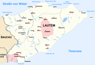
The Namaluto flows in the south of the Lautém municipality |
||
| Data | ||
| location | Lautém municipality , East Timor | |
| River system | Namaluto | |
| source | Cacavei 8 ° 34 ′ 45 ″ S , 126 ° 54 ′ 11 ″ E |
|
| muzzle | in the Timor Sea coordinates: 8 ° 41 ′ 8 ″ S , 126 ° 57 ′ 17 ″ E 8 ° 41 ′ 8 ″ S , 126 ° 57 ′ 17 ″ E
|
|
| Left tributaries | Tchino, Vahuraru, Tehino, Paunara, Ainarauteu | |
| Right tributaries | Pirusoro, Irarau | |
|
Coast at the mouth of the Namaluto |
||
The Namaluto ( Rio Namaluto , Namalutu) is a river in the East Timorese municipality of Lautém .
course
The Namaluto rises in Suco Cacavei ( Lospalos administrative office ). In the center of Cacavei the Paunara , coming from the Suco Souro (Lospalos) flows into it , which previously merged with the Ainarauteu a little north ; a river that has its origin in Cacavei.
Flowing further south, the Namaluto follows the border between the Sucos Cacavei in the east and Fuat ( Iliomar administrative office ) in the west, later between Lore I (Lospalos) and Iliomar I (Iliomar), until it finally reaches its confluence with the Timor Sea . From Fuat, the Pirusoro and the Irarau flow into the Namaluto beforehand . From the east the Tchino reaches the Namaluto, the border river between the Sucos Cacavei and Lore I.
The source of the Tchino lies in the border area of the Sucos Lore I and Lore II . In the upper reaches the river is also called Tehino . On his way to the west he follows the suco border. Further to the west, the border river between Cacavei and Souro, the Vahuraru , flows into the Tchino. The Tchino falls almost dry outside of the rainy season. In the dry season, gravel and rock debris appear covered with algae. Larger aquatic plants are missing.
To the west of Sucos Lore I is the Ira Lafai spring .
fauna
In 2003 and 2006, researchers examined the fish fauna at various points along the river and found the following species:
Tchino river
- Anguilla reinhardtii
- Awaous melanocephalus
- Belobranchus belobranchus
- Bunaka gyrinoides
- Eleotris fusca
- Kuhlia marginata
- Lentipes sp.
- Sicyopterus hageni
- Sicyopterus longifolis
- Sicyopus zoesterophorum
- Stiphodon semoni
Tchino spring
- Anguilla marmorata
- Awaous melanocephalus
- Belobranchus belobranchus
- Eleotris fusca
- Rhyacichthys aspro
- Sicyopterus hageni
- Sicyopterus micrurus
- Sicyopus zoesterophorum
- Stiphodon semoni
Source Ira Lafai
- Manila dormouse (Giuris margaritacea)
Web links
Individual evidence
- ^ Community maps on the Timor-Leste GIS Portal ( Memento from June 30, 2007 in the Internet Archive )
- ↑ a b c Helen K. Larson, Duncan Buckle, Jessica Lynas, Andrew Storey, Chris Humphrey: Additional records of freshwater fishes from Timor-Leste, with notes on the fish fauna of the unique closed Irasiquero River system , The Beagle, Records of the Museums and Art Galleries of the Northern Territory, 2007 23: 131-135 .

