Urunami
| Urunami | ||
|
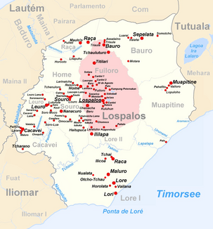
The Urunami flows in the southeast of the administrative office of Lospalos |
||
| Data | ||
| location | Lospalos administrative office, Lautém municipality , East Timor | |
| River system | Urunami | |
| muzzle | in the Timor Sea coordinates: 8 ° 35 ′ 50 " S , 127 ° 5 ′ 14" E 8 ° 35 ′ 50 " S , 127 ° 5 ′ 14" E
|
|
The Urunami (Ribeira Urunami) is an East Timorese river in the administrative office of Lospalos ( Lautém municipality ). The name of the river is derived from the words for "moon" (uru) and "man, male" (nami) in Fataluku .
The Urunami is a small river in the far east of the island of Timor . It rises in the border area between the Sucos Lore I and Muapitine and follows the border line to its confluence with the Timor Sea .
Individual evidence
- ↑ NACHER, Padre Alfonso: Lexico Fataluco-Português . Gráfica Patria, Dili 2012, ISBN 978-84-695-4633-8 ( handle.net ).
- ^ Timor-Leste GIS-Portal ( Memento from June 30, 2007 in the Internet Archive )
