Lapalapa
| Lapalapa | ||
|
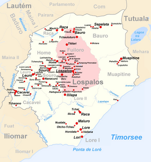
The Lapalapa flows in the southeast of the administrative office of Lospalos |
||
| Data | ||
| location | Lospalos administrative office, Lautém municipality , East Timor | |
| River system | Lapalapa | |
| muzzle | in the Timor Sea coordinates: 8 ° 35 ′ 50 " S , 127 ° 5 ′ 14" E 8 ° 35 ′ 50 " S , 127 ° 5 ′ 14" E
|
|
The Lapalapa ( Ribeira Lapalapa, Indonesian Sungai Lapalapa ) is an East Timorese river in the administrative office of Lospalos ( Lautém municipality ).
geography
The Lapalapa is a small river in the far east of the island of Timor . It is one of the main rivers that flow south along the Paitchau mountain range. The Lapalapa rises in the east of the Sucos Lore II and crosses the northeast of the Sucos Lore I before it flows into the Timor Sea.
fauna
The river has a rocky bottom with round stones. Again and again he forms basins. At least nine species of fish are found in Lapalapa: Anguilla marmorata , Lamnostoma mindora , Lutjanus argentimaculatus , Lutjanus fuscescens , Kuhlia marginata , Kuhlia rupestris , Eleotris fusca , Giuris Margaritacea (Giuris margaritacea) and an unspecified type of sicydiinae .
Even saltwater crocodiles live in the river.
Individual evidence
- ↑ a b c Helen K. Larson, Duncan Buckle, Jessica Lynas, Andrew Storey, Chris Humphrey: Additional records of freshwater fishes from Timor-Leste, with notes on the fish fauna of the unique closed Irasiquero River system , The Beagle, Records of the Museums and Art Galleries of the Northern Territory, 2007 23: 131-135 .
- ^ Timor-Leste GIS-Portal ( Memento from June 30, 2007 in the Internet Archive )
