
Tutuala (Administrative Office)
| Tutuala Administrative Office | |||
|
|||

|
|||
| Administrative headquarters | Tutuala | ||
| surface | 199.92 km² | ||
| population | 3,514 (2015) | ||
| Sucos | Population (2015) | ||
| Mehara | 2,262 | ||
| Tutuala | 1,252 | ||
| Overview map | |||

|
|||

Tutuala is an East Timorese administrative office ( Portuguese Posto Administrativo ) in the municipality of Lautém . Tutuala is the easternmost point of the island of Timor .
geography

Tutuala is East Timor's easternmost administrative office. From the north the Banda Sea with the Strait of Wetar , from the south the Timor Sea encloses the administrative office. The seas meet at Jaco Island, which is part of the administrative office on the eastern tip of Timor. Cape Cutcha and the beach of Valu are on the east coast . To the west, Tutuala borders the administrative offices of Lautém and Lospalos . Tutuala is divided into two sucos : The Suco Tutuala and Mehara . The administrative seat of the administrative office is Tutuala.
Before the 2015 territorial reform, Tutuala had an area of 310.36 km². Now there are 199.92 km² after Tutuala surrendered large parts of its area in the southwest to the administrative office of Lospalos . Until 2014, the administrative offices were still referred to as sub-districts .
The Vero is a river in Suco Tutuala, which flows into the Timor Sea on the south bank. To the northwest of the town of Tutuala lies the small Lagoa Zeleha , a lake that is fed by a river and connected to the Wetar Strait by its outflow.
The Suco Mehara is located on the north shore of the Lagoa Ira Lalaro (also Suro-bec ), which is the largest lake in East Timor at 6.5 km in length and 3 km in width.

The Tutuala Administration Office until 2015

Rock overhang in a small ravine near the Vero

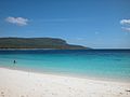
Valu Beach , opposite Jaco Island
Jaco Island

A hamlet in Mehara


The beach of Valu and the forest behind it have been a wildlife sanctuary since 2000 . On July 27, 2007, 123,600 hectares (68,000 hectares of land and 55,600 hectares of sea) were declared Nino Konis Santana National Park, the country's first national park, by the government. The official inauguration took place on August 4th, 2008.
| Jan | Feb | Mar | Apr | May | Jun | Jul | Aug | Sep | Oct | Nov | Dec | year | |
|---|---|---|---|---|---|---|---|---|---|---|---|---|---|
| Average daily maximum [° C] | 30th | 30th | 31 | 32 | 32 | 32 | 32 | 33 | 33 | 32 | 31 | 31 | 33 |
| Average daily minimum [° C] | 23 | 23 | 23 | 24 | 24 | 24 | 24 | 24 | 24 | 24 | 24 | 24 | 23 |
| Average rainfall [mm] | 511.8 | 446.5 | 336.3 | 210.8 | 238.3 | 175.1 | 182.9 | 160.3 | 170.3 | 186.5 | 324.7 | 413.6 | 3357.1 |
| season | Rainy season | dry season | Rainy season | ||||||||||
Residents and economy
The administrative office has 3514 inhabitants (2015), of which 1710 are men and 1804 women. The population density is 17.6 inhabitants / km². The largest language group are the speakers of the national language Fataluku . The last speakers of the national language Makuva , the only native Malayo-Polynesian language in the community, live in Suco Mehara, west of Tutuala . The average age is 17.8 years (2010, 2004: 17.4 years).
17% of households in Tutuala grow corn, 17% cassava, 16% coconuts, 14% vegetables, 11% rice and 2% coffee.
history


There are over 30 caves and rock overhangs in the Tutuala Administration Office, where thousands of pictures have been painted on the walls. For example, Ile Kére Kére ( Ili-kere-kere ) and Lene Hara , near the beach of Valu. The exact age of the drawings has never been determined, although it is certainly considerable. The estimates for the paintings in Ile Kére Kére are 2,000 to 6,000 years ago. A stone engraving in the Lene Hara cave is 10,000 years old. Other rock paintings can be found on the cliffs of Tutuala and Tunu Taraleu , in Lene Kici , Lene Cécé and Vérulu .
In the limestone cave Jerimalai , near the town of Tutuala, 42,000 year old relics were discovered by archaeologists. These are the oldest traces of human settlement on the Lesser Sunda Islands . Among other things, a fish hook about four centimeters long was found in Jerimalai , which was made from the shell of a sea snail . It is estimated to be between 16,000 and 23,000 years old, making it the oldest known fish hook in the world.
Like many of the ethnic groups of Timor, every clan of the Fataluku (ratu) has a corresponding founding myth, which tells of the immigration of the ancestors to Timor. The Kati ratu and the Tutuala ratu are special . Their legends tell that they come from their current home, which indicates that they may have been in Timor longer than other Fataluku and were assimilated by them. The elders of Tutuala ratu are traditionally called "Lord of the Land" (mua ocawa) . They therefore have special rights and obligations during ceremonies. There are 24 different rats in Suco Tutuala alone.
Around the place Tutuala are the remains of several fortifications ( Portuguese : Tranqueira , fataluku: lata irinu ), with which the Fataluku used to protect their settlements.
In 1999 there was violence in Tutuala in the context of the independence referendum in East Timor in 1999 . Years later you could still see the ruins of destroyed buildings in the village.
politics

The administrator of the administrative office is appointed by the central government in Dili. In 2015 it was Carlito Pereira .
Culture

Twice a year the Mechi of Fataluku, the collection of Meci worms ( Eunice viridis ), takes place on the beach of Valu, on Jaco and other places in the administrative office . The smaller Mechi kiik takes place in the last quarter of the moon in February and the large Mechi boat at the new moon in March . In addition to songs on Fataluku, some are also sung in the “commercial language” at the celebrations. This is Leti , the language of the Indonesian Leti Islands , which can be reached within a day by sailing. Traditionally, there was a lively trade between Tutuala and Leti Islands, among others Batik - sarongs . Since East Timor became independent in 2002, trade across national borders has declined.
In 1970 one could still find numerous holy houses ( Lee-teinu ) in Suco Tutuala. However, most of them were destroyed during the Indonesian occupation. In the meantime, the striking buildings on stilts and with their steep roofs have become a national symbol of East Timor and are being rebuilt.
Web links
Individual evidence
- ↑ a b c d e Direcção-Geral de Estatística : Results of the 2015 census , accessed on November 23, 2016.
- ↑ Jornal da República : Diploma Ministerial no 24/2014 de 24 de Julho - Orgânica dos Postos Administrativos ( Memento of March 4, 2016 in the Internet Archive )
- ↑ a b Direcção Nacional de Estatística: 2010 Census Wall Chart (English) ( Memento from August 12, 2011 in the Internet Archive ) (PDF; 2.5 MB)
- ↑ Ministry of State Administration and Territorial Management : Map of the Tutuala Administrative Office ( memento of June 3, 2016 in the Internet Archive ), accessed on March 10, 2017.
- ↑ Hydrotimor: Iralalaru - Iralalaru Water Flow ( Memento from January 10, 2011 in the Internet Archive ) (English)
- ^ Tutuala Weather, Indonesia Weather Averages . Worldweather online. Retrieved August 12, 2013.
- ↑ Direcção Nacional de Estatística: Census of Population and Housing Atlas 2004 ( Memento of November 13, 2012 in the Internet Archive ) (PDF; 14 MB)
- ↑ Direcção Nacional de Estatística: Suco Report Volume 4 (English) ( Memento from April 9, 2015 in the Internet Archive ) (PDF; 9.8 MB)
- ↑ Sapo.tl: Timor-Leste tem mais de 30 grutas e abrigos com arte rupestre , February 11, 2014 , accessed on September 9, 2014.
- ↑ ABConline, February 11, 2011, Scientists find 10,000-year-old stone carvings
- ^ Sue O'Connor: Nine New Painted Rock Art Sites from East Timor in the Context of the Western Pacific Region , pp. 19 ff., Asia Perspectives, Vol. 42, No.1, 2003 , accessed April 6, 2020.
- ↑ Sue O'Connor , Matthew Spriggs, Peter Veth: Excavation at Lene Hara Cave establishes occupation in East Timor at least 30,000-35,000 years ago , in: Antiquity März 2002, 76, 291, p. 45. ( Memento of 23 September 2015 in the Internet Archive ) (PDF; 1.2 MB)
- ^ Sue O'Connor et al .: Pelagic Fishing at 42,000 Years Before the Present and the Maritime Skills of Modern Humans , Science, Vol. 334, p. 1117, 2011
- ^ Adelaide Now: World's first anglers hooked in Timor , November 26, 2011
- ↑ Andrew McWilliam: Austronesians in linguistic disguise: Fataluku cultural fusion in East Timor ( Memento of November 7, 2014 in the Internet Archive ) (PDF; 171 kB).
- ↑ John Norman Miksic, Geok Yian Goh, Sue O'Connor: Rethinking Cultural Resource Management in South East Asia: Preservation, Development, and neglect. 2011, ISBN 978-0-85728-389-4 .
- ↑ Peter V. Lape: Chronology of Fortified Settlements in East Timor (PDF, 2.2 MB) , Department of Anthropology, University of Washington, Seattle, Washington, USA
- ↑ Ministério da Administração Estatal: Administração Municipal ( Memento of June 1, 2016 in the Internet Archive ).
- ↑ Brochure of the National Park Nino Konis Santana (English; PDF; 3.8 MB), accessed on December 25, 2012
- ^ The Timor-Leste Coastal / Marine Habitat Mapping for Tourism and Fisheries Development Project, Project No 2, Coastal and Marine Ecotourism Values, Issues and Opportunities on the North Coast of Timor Leste, Final Report, October 2009 ( Memento from March 29, 2013 in the Internet Archive ) (PDF; 15.2 MB), accessed on December 28, 2012
- ^ The Timor-Leste Coastal / Marine Habitat Mapping for Tourism and Fisheries Development Project, Project No 4, Conservation Values, Issues and Planning in the Nino Konis Santana Marine Park, Timor Leste - Final Report, October 2009 ( Memento from March 29, 2013 in the Internet Archive ) (PDF; 9.2 MB), accessed on December 28, 2012
- ↑ Lisa Palmer, Demétrio do Amaral de Carvalho : Nation building and resource management: The politics of 'nature'in Timor Leste ( Memento from February 1, 2014 in the Internet Archive ) (PDF; 343 kB) , accessed on December 28, 2012.
- ↑ 07.2 Unlawful Killings and Enforced Disappearances ( Memento from March 25, 2016 in the Internet Archive ) (PDF; 2.5 MB) from the final report of the CAVR (English).
Coordinates: 8 ° 24 ' S , 127 ° 15' E