Nitibe (administrative office)
| Administrative office of Nitibe | ||
|
|
||

|
||
| Administrative headquarters | Citrana | |
| surface | 299.50 km² | |
| population | 12,273 (2015) | |
| Sucos | Population (2015) | |
| Banafi | 1,762 | |
| Professions | 2,801 | |
| Run | 3,754 | |
| Suniufe | 1,817 | |
| Usitaco | 2.139 | |
| Overview map | ||

|
||

|
||
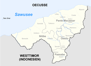
Nitibe ( Nítibe ) is an East Timorese administrative office ( Portuguese Posto Administrativo ) in the Special Administrative Region of Oe-Cusse Ambeno . The main town is Citrana .
geography
Until 2014, the administrative offices were still referred to as sub-districts . Before the 2015 territorial reform, Nitibe had an area of 301.72 km². Now it is 299.50 km².
Nitibe divided into five Sucos : Banafi , Beneufe ( Bene Ufe , Bebe Ufe ), Lelaufe ( Lela Ufe ), Suniufe ( Suni Ufe ) and Usitaco ( Usi Taco ) with the place Nitibe . The main town is the coastal town of Citrana in Suco Beneufe. The highest mountain is the Manoleu at 1171 m in the center of Beneufe. The island of Fatu Sinai ( Batek ), the ownership of which was previously disputed between Indonesia and East Timor, is five kilometers off the coast of the Nitibes administrative office near Citrana . In the meantime, East Timor waived claims. An area around Naktuka , the so-called Citrana Triangle, was controversial until 2019 .
- Climate data
Residents

The Nitibe administrative office has 12,273 inhabitants (2015), 6,109 of whom are men and 6,164 women. The population density is 41.0 inhabitants / km². The largest language group are the speakers of the Atoni dialect of the national language Baikeno . The average age is 18.0 years (2010, 2004: 18.8 years).
history
In September 2009, a group of Indonesian soldiers drove to the East Timorese village of Naktuka (Suco Beneufe) and began taking photos of newly constructed buildings. They were thrown out by the residents and sent back across the border. On May 26, 2010, 28 armed soldiers from the Indonesian armed forces broke into Beneufe and raised their flags in Naktuka , one kilometer from the border. On May 29, 2010, they destroyed the two houses of two social institutions in Suco. On June 24, an armed unit of the Indonesian army again entered the Naktuka area one kilometer, but withdrew when they encountered a unit of the East Timorese border police. Residents see a connection with the unclear demarcation between the countries. This was the worst incident between the two countries since East Timor's independence in 2002. On March 4, 2011, Indonesian soldiers violated the border again and drove residents from the disputed strip of land. On October 28, 2011, Indonesian soldiers shot at East Timorese who had illegally crossed the border in a car.
politics
After the 2004/2005 elections , Miguel Busan was appointed administrator of the then sub-district by the East Timorese government. In 2014 Eurico C. Bobo was administrator.
economy
68% of households in Nitibe have coconut palms, 69% grow cassava, 76% rice, just as many maize, 68% vegetables and 14% coffee.
Web links
Individual evidence
- ↑ a b c d e Direcção-Geral de Estatística : Results of the 2015 census , accessed on November 23, 2016.
- ^ A b Timor-Leste District Atlas: Oecusse District. ( Memento of the original from December 3, 2011 in the Internet Archive ) Info: The archive link was automatically inserted and not yet checked. Please check the original and archive link according to the instructions and then remove this notice. (PDF file; 392 kB) Version 02, August 2008, United Nations Integrated Mission In Timor-Leste (UNMIT), accessed on June 18, 2014.
- ↑ Jornal da República : Diploma Ministerial no 24/2014 de 24 de Julho - Orgânica dos Postos Administrativos ( Memento of March 4, 2016 in the Internet Archive )
- ↑ a b Direcção Nacional de Estatística: 2010 Census Wall Chart (English) ( Memento of the original from August 12, 2011 in the Internet Archive ) Info: The archive link was automatically inserted and not yet checked. Please check the original and archive link according to the instructions and then remove this notice. (PDF; 2.5 MB)
- ↑ Caitlin Sanchez, Venancio Lopes Carvalho, Andrew Kathriner, Mark O'Shea and Hinrich Kaiser: First report on the herpetofauna of the Oecusse District, an exclave of Timor-Leste , Herpetology Notes, volume 5: 137-149 (2012), 28 April 2012 , accessed June 7, 2014.
- ↑ a b Seeds of Life
- ↑ Direcção Nacional de Estatística: Census of Population and Housing Atlas 2004 ( Memento of November 13, 2012 in the Internet Archive ) (PDF; 14 MB)
- ↑ International Crises Group, May 20, 2010, Timor-Leste: Oecusse and the Indonesian Border ( Memento of the original from August 8, 2010 in the Internet Archive ) Info: The archive link has been inserted automatically and has not yet been checked. Please check the original and archive link according to the instructions and then remove this notice.
- ^ Diario Nacional, June 1, 2010, Indonesian TNI raises Merah Putih flag in Oe-cuse
- ↑ Radio Televisaun Timor Leste, June 1, 2010, Indonesia's TNI soldiers destroy social houses in Oe-cusse
- ^ Diario Nacional, March 4, 2011, TNI soldiers illegally enter Naktuka
- ↑ Suara Timor Loro Sa'e, November 18, 2011, Naktuka case investigated
- ^ Ministry of State Administration: Nitibe , accessed June 19, 2020.
- ↑ Direcção Nacional de Estatística: Suco Report Volume 4 (English) ( Memento of the original from April 9, 2015 in the Internet Archive ) Info: The archive link was inserted automatically and has not yet been checked. Please check the original and archive link according to the instructions and then remove this notice. (PDF; 9.8 MB)
Coordinates: 9 ° 21 ′ S , 124 ° 14 ′ E


