Nitibe
| Nitibe | ||
|---|---|---|
|
|
||
| Coordinates | 9 ° 21 ′ S , 124 ° 14 ′ E | |

|
||
| Basic data | ||
| Country | East Timor | |
| Oe-Cusse Ambeno | ||
| Administrative office | Nitibe | |
| ISO 3166-2 | TL-OE | |
| Suco | Usitaco | |
| height | 641 m | |
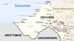
Nitibe ( Nítibe ) is a place in the administrative office of Nitibe in the East Timorese exclave Oe-Cusse Ambeno .
geography
Nitibe is located in Suco Usitaco , about 21 km southwest of the municipality capital Pante Macassar , 641 m above sea level. There is a helipad, a medical station and a primary school, the Escola Primaria Nitibe (Fatubena) . Nitibe has the status of an Aldeia .
Individual evidence
- ↑ UNMIT: Timor-Leste District Atlas version 02, August 2008 ( Memento of the original from December 3, 2011 in the Internet Archive ) Info: The archive link has been inserted automatically and has not yet been checked. Please check the original and archive link according to the instructions and then remove this notice. (PDF; 401 kB)
- ↑ List of polling stations for the parliamentary elections in East Timor 2007 (PDF file; 118 kB)
- ↑ Jornal da Républica with the Diploma Ministerial n. 199/09 ( Memento of February 3, 2010 in the Internet Archive ) (Portuguese; PDF; 323 kB)
