
Pante Macassar (Administrative Office)
| Administrative Office Pante Macassar | |||
|
|||

|
|||
| Administrative headquarters | Pante Macassar | ||
| surface | 356.56 km² | ||
| population | 37,280 (2015) | ||
| Sucos | Population (2015) | ||
| Bobocasse | 2,693 | ||
| Costa | 14,350 | ||
| Cunha | 4,493 | ||
| Lalisuc | 2,182 | ||
| Lifau | 2,505 | ||
| Naimeco | 4,809 | ||
| Nipane | 1,124 | ||
| Taiboco | 5.124 | ||
| Overview map | |||

|
|||

|
|||

Pante Macassar (Pante Makassar, tetum Pante Makasar ) is an East Timorese administrative office ( Portuguese Posto Administrativo ) in the special administrative region of Oe-Cusse Ambeno in the western part of Timor . The administrative headquarters are in Pante Macassar .
geography

Until 2014, the administrative offices were still referred to as sub-districts . Before the 2015 territorial reform,> Pante Macassar had an area of 357.30 km². Now there are 356.56 km².
The Office of Administration Pante Macassar is divided into eight Sucos : Bobocasse ( Bobocasae , Bobocase ), Costa , Cunha , Lalisuc ( Lalisuk ) Lifau , Naimeco , Nipane ( Nipani ) and Taiboco .
- Climate data

Annual rainfall (2000)

Average annual temperature (2000)
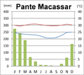
Climate diagram from Pante Macassar


Residents
The administrative office Pante Macassar has 37,280 inhabitants (2015), of which 19,096 are men and 18,184 women. The population density is 104.6 inhabitants / km². The largest language group are the speakers of the national language Baikeno . The average age is 19.0 years (2010, 2004: 19.2 years).
history

1556 founded Dominicans to secure the Sandelholzhandels place Lifau , 6 km west of the modern town of Pante Macassar. From 1702 to 1769 Lifau was the administrative seat of Portuguese Timor . It was in the territory of the Empire of Oecussi, which had its seat in Oesono . The empire was ruled by Topasse . The topasses were descendants of Portuguese soldiers, sailors and traders who married women from Solor . They decisively determined the developments on Timor in the 17th and 18th centuries. In 1769 the Portuguese were forced to move their colonial capital to Dili .
During the rebellion in Cová (1868–1871), Oecussi supported the Portuguese. In May 1912, during the great Manufahi rebellion , there was also an uprising against the colonial rulers in Oecussi. With the support of the gunboat Pátria , the uprising was put down.
In the turmoil of the last months of Portuguese rule over East Timor, Indonesia occupied the exclave Oe-Cusse Ambeno on June 6, 1975. When FRETILIN finally declared East Timor independent from Portugal on November 28, 1975, the Indonesian flag was already on the following day set in Pante Macassar. The invasion of the rest of East Timor began on December 7, 1975.
During the riots of 1999 that followed the independence referendum , Pante Macassar was the target of pro-Indonesian militias , supported by the Indonesian military. 65 civilians who supported independence were hanged and the city of Pante Macassar burned down except for two churches.
politics
After the 2004/2005 elections , Jose “Camada” Martins was appointed administrator of the then sub-district Pante Macassar by the East Timorese government. In 2014 Constancio Suni was administrator.
economy

69% of households in Pante Macassar have coconut palms, 64% grow cassava, 61% vegetables, 73% rice, 79% corn and 14% coffee.
See also
Web links
Individual evidence
- ↑ a b c d e Direcção-Geral de Estatística : Results of the 2015 census , accessed on November 23, 2016.
- ↑ Jornal da República : Diploma Ministerial no 24/2014 de 24 de Julho - Orgânica dos Postos Administrativos ( Memento of March 4, 2016 in the Internet Archive )
- ↑ a b Direcção Nacional de Estatística: 2010 Census Wall Chart (English) ( Memento of the original from August 12, 2011 in the Internet Archive ) Info: The archive link was automatically inserted and not yet checked. Please check the original and archive link according to the instructions and then remove this notice. (PDF; 2.5 MB)
- ↑ a b c Seeds of Life
- ↑ Direcção Nacional de Estatística: Census of Population and Housing Atlas 2004 ( Memento of November 13, 2012 in the Internet Archive ) (PDF; 14 MB)
- ^ Geoffrey Hull: The Languages of East Timor - Some Basic Facts. ( Memento of the original from October 1, 2009 in the Internet Archive ) Info: The archive link was inserted automatically and has not yet been checked. Please check the original and archive link according to the instructions and then remove this notice. Universidade Nacional de Timor Lorosa'e, 2002 (PDF file). Retrieved June 17, 2014.
- ↑ a b History of Timor - Technical University of Lisbon ( Memento of the original from March 24, 2009 in the Internet Archive ) Info: The archive link has been inserted automatically and has not yet been checked. Please check the original and archive link according to the instructions and then remove this notice. (PDF; 824 kB)
- ^ Nations Encyclopedia
- ↑ CAVR-Report: Chapter 7.3: Forced Displacement and Famine ( Memento of the original from November 28, 2015 in the Internet Archive ) Info: The archive link was inserted automatically and has not yet been checked. Please check the original and archive link according to the instructions and then remove this notice. (English; PDF; 1.3 MB)
- ^ Ministry of State Administration: Pante Macassar , accessed on June 19, 2020.
- ↑ Direcção Nacional de Estatística: Suco Report Volume 4 (English) ( Memento of the original from April 9, 2015 in the Internet Archive ) Info: The archive link was inserted automatically and has not yet been checked. Please check the original and archive link according to the instructions and then remove this notice. (PDF; 9.8 MB)
Nitibe | Oesilo | Pante Macassar | Passabe
Coordinates: 9 ° 12 ′ S , 124 ° 23 ′ E
The administrative borders within East Timor changed in 2015. This article must therefore be checked and updated if necessary. See New Administrative Boundaries .