Cribas
| Cribas | ||

|
||
| Data | ||
| surface | 98.10 km² | |
| population | 2,435 (2015) | |
| Chefe de Suco | Eurico Alves (election 2009) |
|
| Aldeias | Population (2015) | |
| Athoc | 490 | |
| Caunua | 458 | |
| Ranac | 517 | |
| Tuquete | 569 | |
| Ueubani | 401 | |
|
|
||
Cribas is an East Timorese Suco in the Manatuto Administrative Office ( Manatuto Municipality ).
geography
| Cribas | ||
| places | position | height |
| Athoc | 8 ° 41 ′ S , 126 ° 0 ′ E | 509 m |
| Tuquete | 8 ° 41 ′ S , 125 ° 59 ′ E | 509 m |
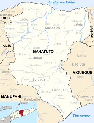
Before the 2015 territorial reform, Cribas had an area of 97.93 km². Now there are 98.10 km². The Suco forms the south of the administrative office of Manatuto. To the north are the sucos Aiteas and Ailili . In the west Cribas borders on the administrative office Laclubar with its Sucos Sananain , Batara and Fatumaquerec , in the south on the administrative office Barique with the Suco of the same name , in the east on the administrative office Laleia with its Suco Cairui . In the south-east, Cribas touches the Lacluta administrative office with its Suco Laline belonging to the municipality of Viqueque . Coming from the south, the Haeraun river crosses the west of Cribas, in the east the Tuqueli rises , which flows into the Bucana , which rises somewhat to the east . At the northeast corner of Criba , the eastern border river Boi flows into the Bucana. These rivers all belong to the Laleias system . Not so the Sumasse , the western border river, and the river that flows into it, the border river to Ailili, the Lago Birac . They belong to the system of Northern Laclós . The Monte Beco Mean lies between the Haeraun and Tuqueli rivers at an altitude of 971 m .
A rural road leads through the west of Cribas from the city of Manatuto on the north coast of Timor to Laclubar in the south. Tuquete ( Tuqueti , Tuquetin ) and Athoc ( Atahoc ), the larger settlements of Sucos, are close to one another . Here is the Escola Primaria Cribas primary school and a pre-secondary school.
In the Suco are the five Aldeias Athoc , Caunua , Ranac , Tuquete and Ueubani .
Residents
The Suco has 2,435 inhabitants (2015), of which 1203 are men and 1232 women. The population density is 24.8 inhabitants / km². There are 358 households in the Suco. Cribas is the center of the Malayo-Polynesian Habun language . Almost 64% of the population name Habun as their mother tongue. Almost 31% speak Idaté , over 2% Tetum Prasa , a further 2% Galoli and a small minority Tetum Terik .
history
At the end of 1979 there was an internment camp in Tuquete for East Timorese civilians ( transit camp ) who were to be relocated by the Indonesian occupiers to better combat the FALINTIL .
politics
In the 2004/2005 elections , Peregrino Xavier Martins was elected Chefe de Suco. In the 2009 elections won Eurico Alves .
economy
There are small oil deposits in Cribas.
Web links
- Results of the 2010 census for the Suco Cribas ( tetum ; PDF; 8.3 MB)
- Results of the 2015 census for the Suco Cribas (tetum; PDF)
- Seeds of Life: Suco information sheets Manatuto (tetum)
Individual evidence
- ↑ a b c d Direcção-Geral de Estatística : Results of the 2015 census , accessed on November 23, 2016.
- ↑ Fallingrain.com: Directory of Cities, Towns, and Regions in East Timor
- ↑ Direcção Nacional de Estatística: Population Distribution by Administrative Areas Volume 2 English ( Memento from January 5, 2017 in the Internet Archive ) (Census 2010; PDF; 22.6 MB)
- ^ Timor-Leste GIS-Portal ( Memento from June 30, 2007 in the Internet Archive )
- ↑ List of polling stations for the parliamentary elections in East Timor 2007 (PDF file; 118 kB)
- ↑ UNMIT: Timor-Leste District Atlas version 02, August 2008 ( Memento from December 3, 2011 in the Internet Archive ) (PDF; 581 kB)
- ↑ Jornal da República: Diploma Ministerial n ° 16/2017 , with corrections dated May 9, 2017 , accessed on March 12, 2019.
- ↑ Results of the 2010 census for the Suco Cribas ( tetum ; PDF; 8.3 MB)
- ↑ CAVR Chega Files: Part 7.3: Forced Displacement and Famine ( Memento from November 28, 2015 in the Internet Archive ) (PDF; 1.3 MB)
- ↑ Secretariado Técnico de Administração Eleitoral STAE: Eleições para Liderança Comunitária 2004/2005 - Resultados ( Memento of August 4, 2010 in the Internet Archive )
- ↑ Secretariado Técnico de Administração Eleitoral STAE: Eleições para Liderança Comunitária 2009 - Resultados ( Memento of August 4, 2010 in the Internet Archive )
