Fatumea
| Fatumea | ||

|
||
| Data | ||
| surface | 59.84 km² | |
| population | 787 (2015) | |
| Chefe de Suco | Francisco Paty Jagky Don Bosco Tilman (election 2009) |
|
| Aldeias | Population (2015) | |
| Fatumea | 357 | |
| Lebo | 140 | |
| Moata Ulun | 99 | |
| Rai Oan | 191 | |
|
|
||
Fatumea ( Fatumean ) is a Suco , Aldeia and the capital of the East Timorese administrative office Fatumean ( municipality of Cova Lima ). Until 2003 the Suco was called Alasleten .
Place name
In 1936 the Portuguese renamed Fatumea Oliveira . But the name did not catch on and a few years after the Second World War , the old name was reverted to.
The place
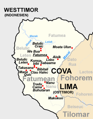
The place Fatumea is located in the southwest of the Sucos, 93 km as the crow flies southwest of the state capital Dili and about 28 km northwest of the municipal capital Suai at an altitude of 877 m . ' Lebo ( Lehu ) is located in the immediate vicinity of Fohoren . In Fatumea there is a medical station, an expanded helipad and a school for preparation for secondary school, the Escola Presecundaria Fatumean .
The Suco
| Fatumea | ||
| places | position | height |
| Aisik | 9 ° 14 ′ S , 125 ° 3 ′ E | 880 m |
| Fatumea | 9 ° 14 ′ S , 125 ° 2 ′ E | 877 m |
| Lebo | 9 ° 14 ′ S , 125 ° 2 ′ E | 877 m |
| Moata Ulun | 9 ° 13 ′ S , 125 ° 4 ′ E | 1185 m |
787 inhabitants (2015) live in Suco Fatumea, of which 391 are men and 396 women. The population density is 13.2 inhabitants / km². There are 171 households in the Suco. Almost all residents give Tetum Terik as their mother tongue. A small minority speaks Adabe .
The Suco is to the north of the Fatumean Administrative Office. To the southwest is the Suco Belulic Leten and south of the Suco Nanu . In the southeast, Fatumean borders the Fohorem administrative office with its Suco Dato Rua . In the north is the Indonesian West Timor . The border river to the neighboring country is provided by the Lelosi , a tributary of the Tafara . The Masai flows along the border to Dato Rua, into which the southern border river to Nanu also flows. The Masai is also a tributary of the Tafara. The Lelak rises in Fatumea and shortly afterwards flows into the Merak , the border river to the Belulic Leten, which finally flows on to Indonesia. The other two larger settlements, Aisik and Moata Ulun ( Mota Ulun , Motaulan ) are also on the rural road that runs parallel to the border with Dato Rua . There is an overland road through the south of the Sucos, including Fatumea, but for the parliamentary elections in East Timor in 2007 the ballot boxes had to be brought by helicopter to the polling station in the pre-secondary school and picked up.
Before the territorial reform in 2015, Fatumea had an area of 56.39 km², but then Belulic Leten gave it a small territory west of the town of Fatumea, so that the Suco now has an area of 59.84 km².
The four Aldeias Fatumea , Lebo , Moata Ulun and Rai Oan are located in the Suco .
politics
In the elections of 2004/2005 was Francisco Paty Jagky Don Bosco Tilman elected Chefe de Suco and in 2009 re-elected.
Web links
- Results of the 2010 census for the Suco Fatumea ( tetum ; PDF; 8.3 MB)
- Results of the 2015 census for the Suco Fatumea (tetum; PDF)
- Seeds of Life: Suco information sheets Fatumean (tetum)
Individual evidence
- ↑ a b c d Direcção-Geral de Estatística : Results of the 2015 census , accessed on November 23, 2016.
- ↑ Division of East Timor under the Indonesian administration ( Memento from September 29, 2007 in the Internet Archive )
- ↑ Map in the Cova Lima District Development Plan 2002/2003 ( Memento of October 14, 2013 in the Internet Archive ) (English; PDF file; 2.24 MB)
- ↑ Geoffrey Hull : The placenames of East Timor , in: Placenames Australia (ANPS): Newsletter of the Australian National Placenames Survey, June 2006, pp. 6 & 7, ( Memento of February 14, 2017 in the Internet Archive ). September 2014.
- ↑ Fallingrain.com: Directory of Cities, Towns, and Regions in East Timor
- ↑ UNMIT: Timor-Leste District Atlas version 02, August 2008 ( Memento from December 3, 2011 in the Internet Archive ) (PDF; 449 kB)
- ↑ a b List of polling stations for the parliamentary elections in East Timor 2007 (PDF; 118 kB)
- ↑ Fallingrain.com: Directory of Cities, Towns, and Regions in East Timor
- ↑ Results of the 2010 census for the Suco Fatumea ( tetum ; PDF; 8.3 MB)
- ↑ a b Timor-Leste GIS Portal ( Memento from June 30, 2007 in the Internet Archive )
- ↑ Direcção Nacional de Estatística: Population Distribution by Administrative Areas Volume 2 English ( Memento from January 5, 2017 in the Internet Archive ) (Census 2010; PDF; 22.6 MB)
- ↑ Jornal da Républica with the Diploma Ministerial n. 199/09 ( Memento of February 3, 2010 in the Internet Archive ) (Portuguese, PDF, 315 kB)
- ↑ Secretariado Técnico de Administração Eleitoral STAE: Eleições para Liderança Comunitária 2004/2005 - Resultados ( Memento of August 4, 2010 in the Internet Archive )
- ↑ Secretariado Técnico de Administração Eleitoral STAE: Eleições para Liderança Comunitária 2009 - Resultados ( Memento of August 4, 2010 in the Internet Archive )
