
Cova Lima
|
Munisípiu Kovalima (tetum) Município de Cova Lima (port.) |
||

|
||
  |
||

|
||
| Data | ||
| Capital | Suai | |
| surface | 1,198.59 km² (7.) | |
| Population (2015) | 65,301 (8.) | |
| Population density | 54.48 inh / km² (9.) | |
| Number of households (2015) | 12,564 (7.) | |
| ISO 3166-2: | TL-CO | |
| Administrative offices | Residents | surface |
| Fatululic | 2,027 | 46.42 km² |
| Fatumean | 3,330 | 132.10 km² |
| Fohorem | 4,086 | 131.46 km² |
| Maucatar | 8,895 | 138.68 km² |
| Suai | 25,815 | 272.85 km² |
| Tilomar | 7,885 | 194.13 km² |
| Zumalai | 13,263 | 282.94 km² |
| map | ||

|
||
Cova Lima ( Covalima , tetum Kovalima , also Koba Lima ) is a municipality in the southwest of East Timor . There are two different explanations for their name. On the one hand, it could be derived from “ Koba ” (a basket used for ritual acts) and “lima”, the Tetum word for “five”. This number represents the five mythical daughters of Liurai (traditional title of a Timorese ruler) by Fohorem Nutetu . In Dato Tolu ( Fohorem Administrative Office ) there are five stones in a betel nut grove that represent the five daughters. According to another explanation, the community name is derived from "Kaua Lima", which means "five crows" in Tetum.
The Portuguese only took control of the region around 1900. Only the administrative office of Maucatar was not handed over to Portugal by the Dutch until 1912 . Parts of Cova Lima were occupied by Indonesia as early as November 1975, one month before the open invasion began. In 2002, Cova Lima was given independence as part of East Timor.
From the mountains in the north, plains extend south to the Timor Sea . More than half of the population speaks Bunak as their mother tongue , most of the others speak Tetum. The community is sparsely populated than most of the other regions in the country. In addition to the numerous births, the population is also growing due to the immigration of East Timorese from other parts of the country.
geography
Since the territorial reform of 2015, Cova Lima has an area of 1198.59 (before 1206.66 km²), which is roughly half that of Saarland , and is located in the southwest of East Timor, on the Timor Sea. It borders in the north on the municipality of Bobonaro , in the east on Ainaro and in the west, with West Timor , on the Indonesian province of East Nusa-Tenggara .
The municipality's capital is Suai , 138 km southwest of Dili, the capital of East Timor . It lies in the Suco Debos (Debus) . The latter is the only Suco in Cova Lima classified as " urban ". The administrative offices are Fatululic (Fatululik) , Fatumean (Fatumea) , Fohorem (Fohoren, Fuorém) , Maucatar , Suai , Tilomar (Tilômar) and Zumalai (formerly Mape-Zumalai ). Zumalai only came to Cova Lima with the 2003 territorial reform from Ainaro.
The north and northwest are mountainous, while to the south, plains extend along the coast. These are regularly flooded during the rainy season . It begins in October with increasing rainfall, which is strong between November and May and sometimes extends into June. Apart from the occasional rain, the period between June and October is dry. The original vegetation of the plains consisting of dense bushes was partly cleared for agricultural use. On the coast, sandy and rocky beaches alternate. Mangrove swamps can be found in some places. The mountain region is difficult to access and is partly covered by forests. Where there is no forest, there are mountain pastures. The highest mountain in the municipality is the Foho Taroman in the Fatululic administrative office at 1744 m . The mountain used to be a sanctuary of traditional belief in spirits.
At the border with Indonesia the Masin (Mota Talas) flows into the Timor Sea, between Cape Tafara and Cape Suai the Tafara . The rivers Camenaça , Raiketan , Foura , Loumea , Mola and finally the Belulik , the border river to the municipality of Ainaro, follow eastwards . The Onu Laran in the south of Beiseuc is the largest lake in Cova Lima.

Places and waters in Cova Lima
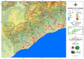
Road network and topography of Cova Lima

Climate diagram of Suai


Residents


With 65,301 inhabitants (2015, 2011: 62,465), Cova Lima is one of the more sparsely populated communities in the country. There are 54.48 inhabitants per square kilometer (2015). The administrative office of Suai is most densely populated with 94.6 inhabitants per square kilometer, Fatumean the least populated with 25.2 (2015, national average: 79.3). In November 1998, it was estimated that just over 60,000 people were living in Cova Lima. But because of the wave of violence during the Indonesian Operation Donner in 1999, 25% of the population fled to West Timor or were forcibly deported there. Several thousand fled to other regions. The increase in the population in the following years was therefore caused not only by natural growth but also by returnees. By April 2001 alone, almost 29,000 people had returned to Cova Lima. Between 1990 and 2004 the number of residents grew by 1.13% annually. The average age is 18.6 years (2010).


In 2004, a woman had an average of 8.75 children in what was then the Fatululic sub- district . He was at the top in Cova Lima, although there is a clear surplus of women in Fatululic, while in the other subdistricts the gender ratio was balanced. A woman had an average of 7.79 children in Zumalai, 7.21 in Maucatar, 6.61 in Fatumean, 6.58 in Tilomar, 6.25 in Fohorem and 6.01 in Suai (national average 6.99).
In 2002, the infant mortality rate in Tilomar was 71 deaths per 1000 live births (1996: 115), in Fatumean 77 (109), in Suai 97 (123), in Fohorem 115 (132), in Zumalai 126 (189) and in Maucatar at 135 (126). The national average was 98. The Tilomar administrative office can thus point to one of the largest decreases in child mortality in the country, while Maucatar is one of 14 administrative offices in which it rose against the national trend. Maucatar is one of the eight administrative offices with the highest child mortality rates in the country.
48.0% of the residents of Cova Lima (2015) speak the national language Bunak as their mother tongue. They represent the largest population group in the administrative offices of Fatululic, Zumalai, Maucatar, in most of Suai and in the northeast of Fohorem. The northeast of Cova Lima and the southeast of Bobonaro form the heartland of the settlement area of the Bunak . In the areas further to the west, south and east the Bunak spread only later and partially assimilated the Tetum there . 46.3% of the inhabitants of Cova Lima speak Tetum, mostly Tetum Terik (39.7%). The Tetum are the largest group in the administrative offices of Fatumean, Fohorem (mainly in the southwest), Suai ( Camenaça , Suai Loro and Gala ) and Tilomar. In Maucatar, the majority in Matai speaks Tetum Terik. 5.0% speak Kemak in Cova Lima . The Kemak ethnic group make up the majority of the population in Mape and large groups in Ucecai and Lepo . 144 residents speak Adabe , more than half of all speakers of this Papuan language . If the second languages are also taken into account, in 2015 93.2% spoke Tetum, 43.7% Bahasa Indonesia, 32.1% Portuguese and 15.6% English .
In 2015, 39.2% of residents aged three or over attended school. 32.6% had left school. 26.6% have never attended school, 2% less than the national average. However, 4% of the residents only attended pre-school, around a third went to primary school. Secondary schools have completed about another third of the population. Only 3.7% have a diploma or a degree; this corresponds to half of the national average. The illiteracy rate in 2015 was 12.3% (women: 11.1%; men: 13.5%). In 2004 it was still 51.3%.
| Education | Graduation | ||||||||||
| at school | Finished school | never in a school | Preschool | primary school | Pre- secondary |
Secondary | Diploma / University of Applied Sciences |
university | No graduation | ||
| Women | 38.2% | 30.8% | 29.5% | 3.8% | 28.2% | 15.8% | 15.0% | 0.5% | 2.4% | 1.5% | |
| Men | 40.3% | 34.5% | 23.8% | 4.1% | 31.8% | 14.3% | 17.1% | 0.8% | 3.8% | 1.2% | |
| total | 39.2% | 32.6% | 26.6% | 4.0% | 30.0% | 15.1% | 16.1% | 0.6% | 3.1% | 1.4% | |
In 1975 the proportion of followers of the traditional, animistic religion of Timor was estimated at around 60% of the total population of Portuguese Timor . In 1997, 93% of Cova Lima's residents were Catholics, 3% Hindus, 2% Protestants and 2% Muslims. Animists were not counted by the Indonesian occupation forces. Due to the political unrest of 1999 and the subsequent independence of East Timor, Indonesian officials and other Indonesian immigrants left the country, causing the number of Muslims and Hindus to decline. In 2004, 99.8% of the population were Catholics , 0.1% Animists, 28 Muslims , 15 Protestants , nine Buddhists and three Hindus. The 2015 census recorded 99.6% Catholics, 0.26% Protestants, 34 Muslims, ten animists, six Buddhists, one Hindu and 53 others. The old animistic belief still has a great influence in everyday life today.
history
Prehistory and the Portuguese Colonial Era


Timor’s pre-colonial history is only known orally, as the peoples of the island did not use any script. Originally, five kingdoms ruled the core region of the municipality: Camenaça (Kamenasa) , Suai, Maucatar, Taroman and Fohorem. Fohorem dominated the other empires through diplomacy, marriage politics, and campaigns of conquest. After the Liurai of Fohorem had secured sovereignty over the region, he gave each of his five daughters their own kingdom as a fief. In return, they paid tribute in the form of agricultural and forestry products. Another source states that the three kingdoms Fatumean, Lookeu and Dakolo initially joined together to form the Uma Tolu ("Three Houses") coalition . Only after a war against the Portuguese did the kingdoms of Sisi and Maudemi join them, and Koba Lima was created . By corruption, "Koba" later became the Portuguese "Cova", which actually means "pit". Through the colonial demarcation, with the Treaty of Lisbon , between the Netherlands and Portugal, Sisi, Maudemi and half of Lookeus came to what is now Indonesia's West Timor. Ties across the border still exist today. Accordingly, Suai did not belong to Koba Lima , but formed an independent, powerful empire. The source incorrectly names Suai as the center of Wehale , which was further to the west.
Antonio Pigafetta also visited Timor as part of the Magellan's expedition . He told of four main kings of Timor who were brothers: Oibich, Lichisana, Suai and Canabaza . At this time, Suai probably formed a double empire with Canabaza (i.e. Camenaça), which Wehale ( called Oibich by Pigafetta ) had to pay tribute to.
In 1719 the Liurais of about a dozen rich met in Camenaça to conclude a blood pact. The aim of the federal government was to expel the Portuguese and Christianity as a whole. The Camenaça Pact (Camenace Pact) is considered to be the beginning of the Cailaco Rebellion (1719–1769). Under the leadership of Camenaça, churches were destroyed and missionaries and converted Timorese were murdered. Camenaça signed a peace treaty with Portugal on September 19, 1731.
After the Treaty of Lisbon of 1859, Maucatar was officially under Dutch sovereignty. The boundaries of the enclave were based on the boundaries of the local Bunak empires. Today the area belongs to the Sucos Holpilat , Taroman , Fatululic , Dato Tolu and Lactos . All around were Timorese empires that were assigned to Portugal. Only the empire of Lakmaras formed a connection between Maucatar and the rest of the Netherlands from the north.
In 1860 Raemean , Suai and Camenaça were assigned to the Alas military command . In 1883 most of what is now Cova Lima came to the Bobonaro military command . In March 1895, the Portuguese governor José Celestino da Silva began an offensive against Fohorem, Fatumean and other empires to bring them finally under the control of the colonial power. During the War of Manufahi (1894-1896) warriors from Fatumean temporarily occupied the fort of Batugade , when its garrison fought elsewhere. The Liurai of Suai also allied themselves with the Liurai of Manufahi against the Portuguese colonial rulers. In September 1895, the ruler of Fatumean signed a written treaty with Portugal on his vassal status. In 1900 Manufahi capitulated. Suai had been defeated before and became the site of a Portuguese military post at the turn of the century. Over time, Fohoren (Fohorem Administrative Office) became the administrative center of Cova Lima. The Portuguese valued the mountainous region because of the cooler climate. In addition, places on heights, such as Aidikur (Fatumean), Tilomar, Mape and Fohoren, offered better protection against attackers.
In 1897 a war broke out between Lakmaras and the kingdom of Lamaquitos , which was on the Portuguese side in Bobonaro. Colonial troops were also involved in the fighting. Lakmaras finally fell under the supremacy of Lamaquitos and thus under Portuguese suzerainty. Maucatar was now an exclave and should now fall to Portugal after the contract. On the other hand, the realm of Tahakay , north of Fatululic, had meanwhile fallen to the realm of Lamaknen . Tahakay previously belonged to the Portuguese sphere of influence, Lamaknen to the Dutch. Portugal resisted this loss in the negotiations of 1902 and therefore now demanded the entire Dutch territory in central Timor. A compromise was reached with the The Hague Convention of October 1, 1904. Portugal was to receive Maucatar in exchange for the Portuguese enclave Noimuti in West Timor and the border areas of Tahakay, Tamira Ailala (east of Fatumean) and Lamaknen. Portugal ratified the treaty until 1909, but then there was a dispute over the demarcation of the border on the eastern border of Oe-Cusse Ambeno . The exchange of territory was delayed. In 1910 the Netherlands took advantage of the confusing situation after the fall of the Portuguese monarchy to reappropriate Lakmaras with European and Javanese troops. In February 1911, Portugal tried to occupy Maucatar following the 1904 Convention. However, in June it was faced with a superior Dutch force made up of Ambrose infantry, supported by European soldiers. On June 11th, the Portuguese occupied Lakmaras territory, but on July 18th, Dutch and Javanese troops also invaded the area.

In October 1911 the Manufahi rebellion broke out , which put the Portuguese in distress. The military post in Suai was evacuated on December 8, 1911 for fear of the insurgents. On December 29th, 1,200 Timorese sought protection in Maucatar, the Netherlands, because they feared reprisals from the Portuguese. Among them were the Liurai of Camenaça and his entourage. The rebellion quickly spread throughout the region and was not finally put down by the Portuguese until April 1912. The weakening of Portugal by the rebellion made it ready for negotiations with the Dutch on defining the final border. On August 17, 1916, the treaty was signed in The Hague, which largely defined the border between East and West Timor that still exists today. On November 21st, the territories were exchanged. Among others, Lakmaras, Tahakay and Tamira Ailala fell to the Netherlands. Maucatar went to Portugal, which caused a panic there. Before the handover to the Portuguese, 5,000 locals, mostly Bunak, destroyed their fields and moved to the Dutch part of Timor. In Tamira Ailala, they would have preferred to stay with Portugal while the rulers of Tahakay welcomed the move to the Dutch.
The small port of Becos on the Timor Sea played an important role in the Allied supplies and as an evacuation point during the Battle of Timor in World War II against the Japanese occupiers. After the restoration of Portuguese control, Fohoren (then Nova Gouveia ) lost its status as the seat of the local administration and was subordinate to the administrator of Bobonaro in the district (conselho) Fronteira . In 1961, Cova Lima became an independent circle. The local administration came to Debos near Suai. With its plane, Suai offered aircraft the opportunity to land, and it also had access to the sea and was therefore accessible to ships.
Indonesian occupation and UN administration

During the preparations for the colony's independence in 1975, Indonesia began to occupy parts of Cova Lima and the then Bobonaro district from October 16 . Since an appeal for help by FRETILIN , the largest East Timorese party, to the UN Security Council was without consequences, it unilaterally proclaimed independence from Portugal on November 28th . On December 7th, Indonesia openly began occupying the rest of the country . From February 1976 the Indonesian army advanced massively in Cova Lima. The goal was initially the larger towns. To avoid the attacks, most of the inhabitants of the former sub-districts Fohorem, Fatululic, Fatumean and Tilomar fled to Mount Taroman, others to the villages of Dato Tolu , Fatuloro , Taroman and Lactos . The people of Suai either went to Maucatar for safety or hid in their plantings for a few days before surrendering to the invaders. Some of the people from Zumalai fled to Lolotoe and spread out in an area between Lewalu (Gala) , Zoilpo , the Zoba Zova hill in Opa and Labarai . Others went to the hilly area of Zulo . Some residents on the border fled to the Indonesian western part of the island, while people in the remote mountainous regions remained undisturbed by the Indonesian attacks for longer. Many East Timorese and Indonesians died in fighting on Mount Lak Hirin (Laquirin) in the Maucatar sub- district in 1976. In 1989 a memorial in the form of a cross was erected here to commemorate the victims.
Since the refugees had little food to take with them while fleeing, they soon became hungry. After about two months, FRETILIN organized food for the refugees so that they could survive in the mountains for another year and a half. Several bases de apoio (resistance bases ) were created, in which the refugee civilian population settled. At the end of 1977 the Indonesian army began destroying the resistance bases. People were dispersed or captured. By February 1978, Cova Lima was completely under Indonesian control. The Serious Crimes Unit of UNTAET reported that in Suai during the Indonesian occupation so-called Rape Houses existed. On April 28, 1998, the residents of Camenaça were attacked by the Indonesian army. Many residents were forcibly relocated by the occupying forces for better control. Many bunaks from northern Sucos Cova Limas, such as Fatululic and Taroman , came to the lowlands on the coast. The official goal was a development program for rice cultivation.

After the independence referendum in East Timor in 1999 , in which the overwhelming majority of East Timorese voted for independence from Indonesia, there were massive outbreaks of violence by pro-Indonesian militias throughout East Timor . One of the worst incidents nationwide was the Suai church massacre , in which the Laksaur militia and the Indonesian military killed up to 200 people. The villages of Camenaça , Fatuc Metan , Holpilat and Nainare were destroyed. 15 people were murdered in Lactos by Indonesian soldiers and members of the Laksaur militia. Four people were killed in Matai .
With the arrival of the international intervention force INTERFET and the establishment of the UN administration , peace and order were restored. 550 New Zealand , 120 Nepalese , 120 Fijian , 35 Irish and 35 Singaporean soldiers were stationed in Cova Lima . In addition, 120 Japanese engineers worked in Cova Lima. On July 24, 2000, the New Zealand INTERFET soldier Leonard Manning was shot dead in a skirmish with nine militiamen on Foho Debululik Hill . It was the first time a New Zealand soldier had died in combat since the Vietnam War , and Manning was the first INTERFET soldier to be killed in combat. On August 10, Nepalese UN soldier Devi Ram Jaishi died while fighting with a militia near Beco . Three other Nepalese soldiers and one East Timorese civilian were injured. On July 30, 2001, an Indonesian soldier was shot dead by New Zealand soldiers at the Tilomar border after opening fire on them. In 2002 East Timor finally gained its independence.
Cova Lima in independent East Timor

In the suco elections in May 2005 , 90 women were elected to the Cova Limas suco council for the first time. That corresponds to around three women per village. In Fatululic, Lucia Guteres was the first woman ever to be elected boss of a sucos in Cova Lima. She prevailed against four other candidates.
In early 2010 there were reports that gunmen disguised as ninjas were terrorizing the populations in Cova Lima and Bobonaro. The Timorese Police (PNTL) and Army (F-FDTL) then sent units to take action against the criminals. 118 people were captured in the action, seven of them arrested.
politics

|
District President (Bupati) |
|
| Américo da Costa Nunes ( APODETI ) | May 1977 - approx. 1981 |
| Rui Emiliano Teixeira Lopes ( UDT ) | approx. 1981-1994 |
| Colonel Herman Sediono (military) | 1994-1999 |
|
Civil Administrator |
|
| Kenji Isezaki | March 2000 - June 2001 |
|
Administrador |
|
| Abel dos Santos Fátima | 2002-2004 |
| Francisco Mendosa da Costa | in charge of August 2006 |
| Inácio da Silva Pires | around 2009–2011 |
| Agostinho Mendonça | around 2014 |
| Afonso Nogueira Nahak | current (as of 2019) |

In 2014, the districts across East Timor were transformed into "parishes" and the sub-districts into "administrative offices".
The administrator Cova Limas is appointed by the state government in Dili. From 2002 to 2004 this was Abel dos Santos Fátima . In 2011 the office was held by Inácio da Silva Pires , and in 2014 by Agostinho Mendonça . The current administrator is Afonso Nogueira Nahak (as of June 2019).
In the elections to the constituent assembly , which later became the national parliament, FRETILIN won 61.42% of the vote in Cova Lima. The direct mandate at that time was won by Gervasio Cardoso de Jesus da Silva from FRETILIN. In the parliamentary elections in 2007 , FRETILIN also succeeded in getting most of the voters behind with 28.0%. In the parliamentary elections in 2012 , however, the ruling Congresso Nacional da Reconstrução Timorense (CNRT) won 31.4%, while FRETILIN only came in second with 26.4%. In 2017 , the CNRT was again ahead with 28.2%. The second strongest party was the Partido Democrático (PD) with 22.6%, just ahead of FRETILIN with 22.0%. In the early elections in 2018 , the Aliança para Mudança e Progresso (AMP) , to which the CNRT now belonged, received 49.4% of the vote.
In the first round of the 2007 presidential elections , Fernando de Araújo from the PD in Cova Lima received 32.69% of the vote, while the FRETILIN candidate Francisco Guterres received 26.55%. In 2012 , Araújo received 28.32%, Guterres 25.62% and the later election winner Taur Matan Ruak 20.77%. In the 2017 presidential election in Cova Lima, the nationwide winner Francisco Guterres from FRETILIN won the most votes.
The emblem of the administration of the municipality of Cova Lima was adopted in 2014.
Economy and Infrastructure
| Share of households with ... | ||
| agriculture | ||
| Field crops | Share 2010 | Production 2008 |
| Corn | 58% | 9,096 t |
| rice | 26% | 6,022 t |
| manioc | 56% | 3,508 t |
| coconuts | 51% | not specified |
| vegetables | 51% | 883 t (with fruit) |
| coffee | 18% | not specified |
| Livestock | ||
| Livestock | Share 2010 | Number of animals 2010 |
| Chicken | 72% | 47,457 |
| Pigs | 79% | 31,609 |
| Bovine | 49% | 22,378 |
| Water buffalo | 6% | 2,545 |
| Horses | 9% | 1,591 |
| Goats | 17% | 7,038 |
| Sheep | 1 % | 716 |
| Furnishing | ||
| Furnishing | Share 2010 | Number of households |
| radio | 25% | 2,763 |
| watch TV | 14% | 1,589 |
| Telephone (mobile / landline) | 45% | 4,973 |
| fridge | 5% | 541 |
| bicycle | 13% | 1,481 |
| motorcycle | 18% | 2.008 |
| automobile | 3% | 304 |
| boat | 2% | 249 |


.jpg)
According to the 2010 census, 39% of all residents who are ten years or older work. 4% are unemployed The figures are similar to the national average. 64.4% of households practice arable farming, 88.3% cattle (as of 2010). There is fishing on the coast. The most common are pigs and chickens. Almost half of the households keep cattle, twice as many as the national average. Below this are the proportions of goats, horses, buffalos and sheep. The most common crops are corn (58% of households) and cassava (56%). The proportion here is just above the national average. Vegetables and coconuts each grow more than half of the households in Cova Lima. Only a fifth of households grow coffee, compared to a third in the country. A quarter of households in Cova Lima grow rice, which is close to the national average. Suai Loro is known for its tais . These are brightly colored, woven fabrics that women produce at home.
Several rural roads in different structural quality connect the towns of Cova Lima with one another. They are covered with asphalt and gravel or not at all. From the border with Indonesia the coast runs along the A15 to Suai and is then replaced by the A02 on the way east to the municipality of Ainaro, which also passes Zumalai. The A12 leads north from Zumalai to the municipality of Bobonaro, and the A16 from Suai. From the A15 from Kuitaok (Suco Maudemo, Tilomar administrative office) the A16 leads north, past the towns of Tilomar, with a detour to Fohoren , Fatumea and Fatululic. The A15 meets them further east. In 2018, with the first section between Suai and Fatukaho (Fatukahu), the Suai – Beaco motorway was opened, the country’s first motorway.
The smaller villages are, if at all, only connected to the outside world by the simplest slopes. In the rainy season, road closures due to flooding, demolitions and landslides are normal. The unpaved roads are then often no longer passable. The rains also severely hinder road traffic. All-wheel drive cars are essential, trucks can only drive part of the roads. Intercity buses (Biskota) connect Suai with the state capital Dili in about six hours.
In Suco Labarai (Suai) there is a one kilometer long runway for aircraft up to the size of a Lockheed C-130 . There is a landing place for boats on the sandy beach of Suai Loro , between Cape Suai and Cape Tafara . Larger ships can also anchor safely off the coast. A supply base for the use of the oil fields off the coast is to be created here. Crude oil was also found in Suai Loro as early as the 1970s. There is a border crossing to the Indonesian West Timor in Motamasin . Since 2012 there has been another base of the East Timorese Border Police (UPF) in Salele .
There are weekly markets in Salele (Wednesdays), Beco 1 (Fridays), Suai (Saturdays), Zumalai (Sundays) and Fohoren (Sundays).
94% of Cova Lima's households live in their own house, with another 4% the house belongs to another family member. Only about a sixth of all residential buildings are made of brick or concrete. The majority of the buildings are still made of natural materials such as bamboo, palm fronds or clay. Zinc and iron sheets have prevailed in many places for roofs. However, 40% of the houses are still covered with palm fronds or thatch. In almost half of the houses the floor consists of rammed earth, in 35% of concrete. Overall, the natural materials in Cova Lima are more widespread than in other countries. 69% of households have access to clean drinking water sources (similar to the national average), with only 11% having the water on or in the house. The residents of the other households have to get the drinking water from public pipes, wells, springs or bodies of water. Almost all households use wood for cooking. The national average is 5% less. Almost two thirds use kerosene to generate light and a quarter use electricity. In the national average, half use petroleum and over a third use electricity.
The communal radio station Cova Taroman (FM 94.1 MHz) broadcasts from Suai . 25% of households have a radio, 14% a television.
The beach of Suai Loro, where you can swim and watch saltwater crocodiles , and the beach of Culu Oan are of great tourist interest . In Holbelis there is a large cave with bats and monkeys. It was previously used for animistic rites and has engravings in the rocks around the entrance. There are also several traditional houses there. There is a hot thermal spring in Lepo . Also worth seeing are Fatumean, Foho Taroman, Mount Lak Hirin and the sacred stones of Dato Tolu .
| Share of households with ... | ||||||||
| ... house walls made of ... | ||||||||
| Brick / concrete | Wood | bamboo | Clay | Iron / zinc sheet | Palm fronds | Natural stones | Others | |
| 15% | 6% | 8th % | 2% | 2% | 67% | 0% | 0% | |
| ... roofs made of ... | ... floors made of ... | |||||||
| Palm fronds / straw / bamboo | Iron / zinc sheet | Roof tiles | Others | concrete | Tiles | Soil / loam | Bamboo / wood | Others |
| 40% | 58% | 1 % | 1 % | 35% | 3% | 45% | 15% | 3% |
| Drinking water supply through ... | ||||||||
| Pipe or pump in the house | Line or pump outside | Public pipeline, well, borehole | protected source | unprotected source | Surface water | Others | ||
| 3% | 8th % | 38% | 20% | 24% | 8th % | 1 % | ||
| Energy source for cooking | Light source | |||||||
| electricity | petroleum | Wood | Others | electricity | petroleum | Wood |
Light nut / candle berry |
Others |
| 1 % | 3% | 95% | 1 % | 26% | 63% | 3% | 3% | 5% |
environment

The last stands of sandalwood , the commodity for which Timor was known for centuries, exist in Cova Lima . In 2001 it was estimated that there were still around 250 hectares of sandalwood forest in the municipality, mainly in the Tilomar Administration Office. Smaller areas were also found in Suai, Fohorem, Fatalulik and Fatumean. Commercial logging is prohibited, but controls are difficult to carry out. Clearing for arable farming and plantations for teak also threaten the forest areas.
The forested Tilomar Reserve has been a protected area since 1982 with an area of an estimated 12,800 hectares. In 2000 it was declared a wildlife sanctuary. It was also designated as an Important Bird Area . Rare bird species can be found here, such as the endangered wetar pigeon and the yellow-cheeked cockatoo , but also the maned deer and the estuarine crocodile in the Tafara River .
The asbestos roofs used by Indonesians throughout the community, with which 109 houses were still provided in 2010, are a legacy.
Personalities
- Abel Pires da Silva (* 1976 at Foho Taroman ), computer scientist and politician
Web links
- District Profile 2013 (tetum, PDF file)
- Planu Estartejiku Desenvolvimentu Munisipal (tetum)
- Friends of Suai - Port Phillip partnership website.
supporting documents
- Ministry of State Administration and Territorial Management
- Cova Lima District Development Plan 2002/2003 (English; PDF file; 2.24 MB)
- Geoffrey C. Gunn: History of Timor. Technical University of Lisbon (PDF file; 805 kB)
Individual evidence
- ↑ a b c d e f g h i j k l m n o p q Direcção-Geral de Estatística : Results of the 2015 census , accessed on November 23, 2016.
- ↑ a b c d Cova Lima District Development Plan 2002/2003, p. 5.
- ↑ Geoffrey Hull : The placenames of East Timor , in: Placenames Australia (ANPS): Newsletter of the Australian National Placenames Survey, June 2006, pp. 6 & 7, ( Memento of February 14, 2017 in the Internet Archive ). September 2014.
- ↑ a b c d Direcção Nacional de Estatística: 2010 Census Wall Chart (English) ( Memento from August 12, 2011 in the Internet Archive ) (PDF file; 2.55 MB)
- ↑ Timor-Leste, Eleições Gerais de 2012 , accessed on September 2, 2012
- ↑ GOVERNMENT OF TIMOR-LESTE, THROUGH THE SECRETARIA DE ESTADO DOS RECURSOS NATURAIS: Tasi Mane - Suai Supply Base EIA Terrestrial Flora and Fauna Technical Report , March 23, 2012.
- ↑ Cova Lima District Development Plan 2002/2003, p. 6.
- ↑ a b Timor-Leste GIS Portal ( Memento from June 30, 2007 in the Internet Archive )
- ↑ Direcção Nacional de Estatística: Timor-Leste in figures 2011 (PDF; 3.8 MB) ( Memento from February 19, 2014 in the Internet Archive ), accessed on May 5, 2013
- ↑ Cova Lima District Development Plan 2002/2003, p. 7
- ↑ Cova Lima District Development Plan 2002/2003, p. 57
- ↑ a b c d Census of Population and Housing Atlas 2004 ( Memento of November 13, 2012 in the Internet Archive ) (PDF file; 13.31 MB)
- ↑ a b c d Antoinette Schapper: Finding Bunaq: The homeland and expansion of the Bunaq in central Timor ( Memento of October 24, 2013 in the Internet Archive ), pp. 163-186, in: Andrew McWilliam, Elizabeth G. Traube: Land and Life in Timor-Leste: Ethnographic Essays , 2011
- ↑ a b Cova Lima District Development Plan 2002/2003, p. 10
- ↑ District Pritory Tables: Cova Lima 2004 ( Memento from September 6, 2014 in the Internet Archive ) (PDF file; 12.39 MB)
- ↑ Suai Media Space: Koba Lima - Suai
- ↑ Gunn, p. 17.
- ↑ Gunn, pp. 41-42.
- ↑ Monika Schlicher: Portugal in East Timor. A critical study of the Portuguese colonial history in East Timor from 1850 to 1912. pp. 134-136, Abera, Hamburg 1996, ISBN 3-931567-08-7 , (Abera Network Asia-Pacific 4), (also: Heidelberg, Univ., Diss ., 1994).
- ↑ 150 Anos da criação de distritos em Timor
- ↑ a b c Gunn, pp. 88-89
- ↑ a b c Hague Justice Portal: Island of Timor: Award - Boundaries in the Island of Timor ( Page no longer available , search in web archives ) Info: The link was automatically marked as defective. Please check the link according to the instructions and then remove this notice. (English)
- ↑ Antoinette Schapper: Crossing the border: Historical and linguistic divides among the Bunaq in central Timor , pp. 7-8.
- ↑ a b Gunn, p. 77.
- ↑ Gunn, p. 92.
- ↑ a b "Part 3: The History of the Conflict" (PDF; 1.4 MB) from the "Chega!" Report of the CAVR (English)
- ^ João Soares: Novo Atlas Escolar Português , 5th updated edition, Lisboa 1954.
- ^ Government of Timor-Leste: Administrative Division (English).
- ^ Center for Southeast Asian Studies, Northern Illinois University
- ↑ a b c "Chapter 7.3 Forced Displacement and Famine" (PDF; 1.3 MB) from the "Chega!" Report of the CAVR (English)
- ↑ a b Cova Lima District Development Plan 2002/2003, p. 51.
- ↑ EAST TIMOR: State Violations of East Timorese Human Rights Prevail ( Memento from August 26, 2014 in the Internet Archive )
- ↑ "Chapter 7.2 Unlawful Killings and Enforced Disappearances" (PDF; 2.5 MB) from the "Chega!" Report of the CAVR (English)
- ↑ Cova Lima District Development Plan 2002/2003 ( Memento of October 14, 2013 in the Internet Archive ) (English; PDF file; 2.24 MB).
- ↑ CAVR final report “Chega! Report “: East Timor 1999 Crimes against Humanity ( Memento from December 19, 2009 in the Internet Archive ) (PDF file; 1.65 MB).
- ↑ Australian Defense Image Library: Leonard Manning memorial at Tilomar ( page no longer available , search in web archives )
- ^ Scoop, July 15, 2010, Wreath-laying At Tilomar, Timor-Leste
- ↑ BBC : [ East Timor peacekeeper killed , August 11, 2000], accessed November 29, 2012.
- ↑ AFP: Nepalese UN soldier dies after East Timor shooting , August 10, 2000
- ^ Find Articles, June 30, 2001, Indonesian soldier dies in shoot-out with NZ peacekeepers
- ↑ Oxfam News - December 2005: Timor women create history ( Memento of January 6, 2009 in the Internet Archive )
- ↑ Wikinews, March 24, 2010, “Ninjas” in Timor-Leste?
- ↑ "Part 4: Regime of Occupation" (PDF; 563 kB) from the "Chega!" Report of the CAVR (English).
- ^ District Court of Dili: Case No. 14/2003 Indictment , accessed June 27, 2019.
- ↑ Peng Er Lam: Japan's Peace-Building Diplomacy in Asia: Seeking a More Active Political Role, limited preview in the Google book search.
- ↑ Timor-Leste: SRSG - "District officials responsible for obtaining and spending national budget resources properly for the people" , August 25, 2006 , accessed on June 27, 2019.
- ↑ Office of the Prime Minister: Address by his Excellency the Prime Minister Kay Rala Xanana Gusmão on the Occasion of the Swearing-in of Mr. Abel dos Santos Fátima as the Civil Service Commissioner , accessed on February 15, 2016.
- ^ Website of the government of East Timor: 2,246 temporary employees pass to permanent status
- ^ Descentralização Administrativa na República Democrática de Timor-Leste: Covalima , accessed on February 7, 2014
- ↑ President of East Timor: Abertura ESPOZISAUN AI HAN LOCAL NO ARTEZENATU IHA SUAI , accessed on June 27 of 2019.
- ↑ Lurdes Silva-Carneiro de Sousa: Some Facts and Comments on the East Timor 2001 Constituent Assembly Election ( Memento of October 16, 2013 in the Internet Archive ) ( RTF ; 199 kB), Lusotopie 2001: pp. 299–311.
- ↑ Cova Lima District Development Plan 2002/2003, p. 24.
- ↑ CNE - official results on 9th July 2007 ( Memento from September 27, 2007 in the Internet Archive ) (PDF file; 118 kB)
- ↑ CNE: CNE 2017
- ↑ CNE: Munisipios , accessed May 30, 2018.
- ↑ a b c d e f g h i j k Direcção Nacional de Estatística: Suco Report Volume 4 ( Memento from April 9, 2015 in the Internet Archive ) (English; PDF file; 9.35 MB)
- ↑ a b Direcção Nacional de Estatística: Timor-Leste in Figures 2008 ( Memento from 7 July 2010 in the Internet Archive ) (PDF; 3.7 MB)
- ↑ Timor Agora: Primeiro troço de autoestrada em Timor-Leste inaugurado hoje no sul do país , November 17, 2018 , accessed on December 22, 2018.
- ↑ a b UNMIT: Timor-Leste District Atlas version 02, August 2008 ( Memento from December 3, 2011 in the Internet Archive ) (PDF file; 438 kB)
- ^ Road map of East Timor, 2001.
- ↑ Cova Lima District Development Plan 2002/2003, p. 12.
- ↑ Ministry of Natural Resources, Minerals & Energy Policy of Timor-Leste ( Memento from October 29, 2008 in the Internet Archive ) (English)
- ^ Government of Timor-Leste: Government inaugurates Border Post of Salele (Covalima) , July 12, 2012 , accessed on July 12, 2012.
- ↑ Cova Lima District Development Plan 2002/2003, p. 50
- ↑ ARKTL - Asosiasaun Radio Komunidade Timor-Leste (English)
- ↑ BirdLife IBA factsheet
- ↑ Important Bird Areas in Timor-Leste ( Memento of November 22, 2008 in the Internet Archive ) (PDF file; 1.87 MB)
Coordinates: 9 ° 19 ′ S , 125 ° 15 ′ E
The administrative borders within East Timor changed in 2015. This article must therefore be checked and updated if necessary. See New Administrative Boundaries .