Fohoren
| Fohoren | ||

|
||

|
||
| Data | ||
| surface | 36.74 km² | |
| population | 577 (2015) | |
| Chefe de Suco | Agusto Cardoso (election 2009) |
|
| Aldeias | Population (2015) | |
| Fatuc Bitic Laran | 161 | |
| Fatuc laran | 126 | |
| Lo'o Hali | 4th | |
| Loroquida | 248 | |
| Sadahur | 38 | |
|
|
||
Fohoren is a suco and the capital of the East Timorese administrative office Fohorem in the municipality of Cova Lima .
Place name
There are different statements about the meaning of the name Fohoren ( Fohorem, Fohorém, Fuorém ) from the Tetum . According to one source, Foho means "mountain" and Ren means "peak". Another source translates Fohoreen as "valley".
In 1936 Fohoren was renamed Nova Gouveia by the Portuguese . But the name did not catch on and a few years after the Second World War , the old name was reverted to.
The place
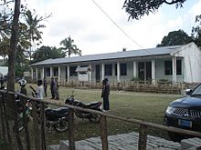
The place Fohoren is 94 km southwest of the state capital Dili as the crow flies and about 20 km northwest of the municipal capital Suai at an altitude of 595 m . In the immediate vicinity of Fohoren there are several localities that form a more or less closed settlement with Fohoren. They are: Fatuc Bitic Laran ( Fatukbitiklaran ), Nularan , Sadahur ( Sadahor ), Lo'o Hali ( Loohali ) and Fatuhesi ( Fatubesi ). There is a primary school ( Escola Primaria Catolica Nossa Senhora do Rosario de Fátima ), two preparatory schools for the secondary level, a developed helipad and a community health center. A country road leads from Tilomar to Fohoren, but for the parliamentary elections in East Timor in 2007 the ballot boxes had to be brought to the polling station in the primary school by helicopter and picked up.
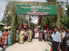
There is a weekly market in Fohoren on Sundays.
The Suco
| Fohoren | ||
| places | position | height |
| Baukama | 9 ° 18 ′ S , 125 ° 9 ′ E | 335 m |
| Fatuc laran | 9 ° 18 ′ S , 125 ° 6 ′ E | 503 m |
| Fatuhesi | 9 ° 17 ′ S , 125 ° 6 ′ E | 427 m |
| Fatuc Bitic Laran | 9 ° 17 ′ S , 125 ° 5 ′ E | 595 m |
| Fohoren | 9 ° 17 ′ S , 125 ° 5 ′ E | 595 m |
| Lo'o Hali | 9 ° 17 ′ S , 125 ° 5 ′ E | 670 m |
| Loroquida | 9 ° 17 ′ S , 125 ° 9 ′ E | 325 m |
| Maubesi | 9 ° 17 ′ S , 125 ° 7 ′ E | 363 m |
| Nularan | 9 ° 17 ′ S , 125 ° 6 ′ E | 506 m |
| Sadahur | 9 ° 17 ′ S , 125 ° 6 ′ E | 595 m |
577 inhabitants (2015) live in Suco Fohoren, of which 282 are men and 295 women. The population density is 15.7 inhabitants / km². There are 148 households in the Suco. About 85% of the population name Tetum Terik as their mother tongue. Over 10% speak Bunak and a minority speak Tetum Prasa .
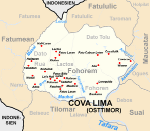
Before the 2015 regional reform, Fohoren had an area of 39.93 km². Now there are 36.74 km². The Suco is located in the south of the Fohorem administrative office. In the west it borders on Suco Dato Rua , in the north on Lactos and Dato Tolu . To the south is the administrative office of Tilomar with its Sucos Beiseuc and Lalawa , to the southeast the administrative office of Suai with the Suco Debos and to the northeast the administrative office of Maucatar with the Suco Ogues . The river Bora flows along part of the western border . It flows into the border river in the south, the Maubui . The same goes for the Nanamauk , which comes from Dato Tolu and flows through the center of Fohoren. At the southeast corner of the Sucos, the Maubui meets the Asaematen , the eastern border river. Together they form the Tafara River .
Most of the larger settlements are in the west. Most of them form a settlement center with the village of Fohoren. A little further southeast is the village of Fatuc Laran ( Fato Claran ). In the center of Sucos, on the west bank of the Nanamauk, is Maubesi and in the east of Sucos, the villages of Loroquida ( Lorokida ) and Baukama .
In the Suco there are the five Aldeias Fatuc Bitic Laran , Fatuc Laran , Lo'o Hali , Loroquida and Sadahur .
history

Fohorem was one of the traditional kingdoms of Timor , ruled by a liurai . It appears on a list by Afonso de Castro , a former governor of Portuguese Timor who listed 47 empires in 1868.
According to oral tradition, Fohorem Nutetu had secured sovereignty in the region through diplomacy, marriage policy and campaigns against other empires. In Dato Tolu there is an old sword that is stuck in a stone. It should come from the ancestors. There are another five striking stones in a betel nut grove . They are said to be related to the five royal daughters who, according to an old legend , ruled Camenaça , Suai, Maucatar , Taroman and Fohorem under the suzerainty of their father. The name should be derived from this. " Koba " (from which "Kova" is derived) is a basket for ritual ceremonies and "lima", the word for "five".
Governor José Celestino da Silva led an offensive against Fohorem and other neighboring empires in March 1895 to finally subdue them for Portugal . Fohoren became the administrative center of the Portuguese in the region. They appreciated the mountainous region because of the cooler climate. In addition, the place on its hill offered better protection from attackers. After the Second World War Fohoren became part of the district (conselho) Fronteira , whose main town was Bobonaro . In 1961, Cova Lima became an independent district with Suai as its capital.
politics
In the 2004/2005 elections , Alarico Agustinho was elected Chefe de Suco. In the 2009 elections won Agusto Cardoso .
Web links
- Results of the 2010 census for the Suco Fohoren ( tetum ; PDF; 7.96 MB)
- Results of the 2015 census for the Suco Fohoren (tetum; PDF)
- Seeds of Life: Suco information sheets Fohorem (tetum)
Individual evidence
- ↑ a b c d Direcção-Geral de Estatística : Results of the 2015 census , accessed on November 23, 2016.
- ↑ Suai Media Space: Koba Lima - Suai
- ↑ a b Geoffrey Hull : The placenames of East Timor , in: Placenames Australia (ANPS): Newsletter of the Australian National Placenames Survey, June 2006, pp. 6 & 7, ( Memento of the original of February 14, 2017 in the Internet Archive ) Info: The archive link was inserted automatically and has not yet been checked. Please check the original and archive link according to the instructions and then remove this notice. accessed on September 28, 2014.
- ↑ Fallingrain.com: Directory of Cities, Towns, and Regions in East Timor
- ↑ a b List of polling stations for the parliamentary elections in East Timor 2007 (PDF file; 118 kB)
- ↑ UNMIT: Timor-Leste District Atlas version 02, August 2008 ( Memento of the original from December 3, 2011 in the Internet Archive ) Info: The archive link has been inserted automatically and has not yet been checked. Please check the original and archive link according to the instructions and then remove this notice. (PDF file; 438 kB)
- ↑ a b c Cova Lima District Development Plan 2002/2003 ( Memento of the original from October 14, 2013 in the Internet Archive ) Info: The archive link was inserted automatically and has not yet been checked. Please check the original and archive link according to the instructions and then remove this notice. (English; PDF file; 2.24 MB)
- ↑ Fallingrain.com: Directory of Cities, Towns, and Regions in East Timor
- ↑ Results of the 2010 census for the Suco Fohoren ( tetum ; PDF file; 7.96 MB)
- ↑ Direcção Nacional de Estatística: Population Distribution by Administrative Areas Volume 2 English ( Memento of the original from January 5, 2017 in the Internet Archive ) Info: The archive link has been inserted automatically and has not yet been checked. Please check the original and archive link according to the instructions and then remove this notice. (2010 census; PDF; 22.6 MB)
- ↑ a b Timor-Leste GIS Portal ( Memento from June 30, 2007 in the Internet Archive )
- ↑ Jornal da Républica with the Diploma Ministerial n. 199/09 ( Memento of February 3, 2010 in the Internet Archive ) (Portuguese, PDF file; 315 kB)
- ↑ TIMOR LORO SAE, Um pouco de história ( Memento of the original dated November 13, 2001 in the Internet Archive ) Info: The archive link was inserted automatically and has not yet been checked. Please check the original and archive link according to the instructions and then remove this notice.
- ↑ East Timor - POortuguese Dependency of East Timor ( Memento of 21 February 2004 at the Internet Archive )
- ↑ History of Timor - Technical University of Lisbon ( Memento of the original from March 24, 2009 in the Internet Archive ) Info: The archive link was automatically inserted and has not yet been checked. Please check the original and archive link according to the instructions and then remove this notice. (PDF file; 805 kB)
- ↑ Secretariado Técnico de Administração Eleitoral STAE: Eleições para Liderança Comunitária 2004/2005 - Resultados ( Memento of August 4, 2010 in the Internet Archive )
- ↑ Secretariado Técnico de Administração Eleitoral STAE: Eleições para Liderança Comunitária 2009 - Resultados ( Memento of August 4, 2010 in the Internet Archive )


