Cape Tafara
| Cape Tafara | ||
| Geographical location | ||
|
|
||
| Coordinates | 9 ° 22 ′ S , 125 ° 15 ′ E | |
| coast | South Timor Coast | |
| Waters | Timor Sea | |
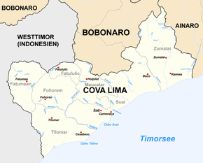
 Map of the municipality of Cova Lima (administrative boundaries before 2015) with Cape Tafara |
||
The Cape Tafara ( Portuguese Cabo Tafara ) is located on the south coast of the island of Timor . It is located in Suco Suai Loro, East Timor, ( Suai Administrative Office , Cova Lima municipality ). To the southwest of the cape, the Tafara River flows into the Timor Sea, which forms the border between the Sucos Suai Loro in the north and Casabauc ( Tilomar administrative office ) in the south.
