
Dampierre-sous-Brou
| Dampierre-sous-Brou | ||
|---|---|---|
|
||
| region | Center-Val de Loire | |
| Department | Eure-et-Loir | |
| Arrondissement | Châteaudun | |
| Canton | Brou | |
| Community association | Communauté de communes du Grand Châteaudun | |
| Coordinates | 48 ° 13 ' N , 1 ° 7' E | |
| height | 152-227 m | |
| surface | 14.56 km 2 | |
| Residents | 461 (January 1, 2017) | |
| Population density | 32 inhabitants / km 2 | |
| Post Code | 28160 | |
| INSEE code | 28123 | |
 Mairie Dampierre-sous-Brou |
||

Dampierre-sous-Brou is a French municipality with 461 inhabitants (at January 1, 2017) in the Eure-et-Loir in the region Center-Val de Loire . It belongs to the arrondissement of Châteaudun and the canton of Brou .
Neighboring communities are Frazé in the north, Brou in the east and Unverre in the south and west.
Population development
| year | 1962 | 1968 | 1975 | 1982 | 1990 | 1999 | 2008 | 2015 |
|---|---|---|---|---|---|---|---|---|
| Residents | 426 | 430 | 440 | 473 | 472 | 446 | 471 | 480 |
Attractions
- War memorial
- Saint-Pierre church from 1713, monument historique

Saint-Pierre church
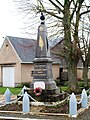
War memorial


Web links
Commons : Dampierre-sous-Brou - Collection of images, videos and audio files