
Tillay-le-Péneux
| Tillay-le-Péneux | ||
|---|---|---|
|
||
| region | Center-Val de Loire | |
| Department | Eure-et-Loir | |
| Arrondissement | Châteaudun | |
| Canton | Voves | |
| Community association | Coeur de Beauce | |
| Coordinates | 48 ° 10 ′ N , 1 ° 47 ′ E | |
| height | 118-141 m | |
| surface | 22.19 km 2 | |
| Residents | 324 (January 1, 2017) | |
| Population density | 15 inhabitants / km 2 | |
| Post Code | 28140 | |
| INSEE code | 28390 | |

Tillay-le-Péneux is a French municipality with 324 inhabitants (as of January 1 2017) in the Eure-et-Loir in the region Center-Val de Loire ; it belongs to the arrondissement of Châteaudun and the canton of Voves (until 2015: canton of Orgères-en-Beauce ). The inhabitants are called Tiglétins .
geography
Tillay-le-Péneux is located about 30 kilometers north-north-west of Orléans . Tillay-le-Péneux is surrounded by the neighboring communities of Éole-en-Beauce in the north and north-west, Allaines-Mervilliers in the north-east, Bazoches-les-Hautes in the east, Bauigneaux in the south-east, Lumeau in the south and south-east and Loigny-la-Bataille in the south and west.
Population development
| year | 1962 | 1968 | 1975 | 1982 | 1990 | 1999 | 2006 | 2013 |
| Residents | 465 | 447 | 314 | 241 | 220 | 293 | 342 | 333 |
| Source: Cassini and INSEE | ||||||||
Attractions
- Dolmen La Pierre Godon, Monument historique since 1979
- Ménainville burial mound, monument historique since 1980
- Villeprévost Castle and Park
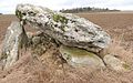
Dolmen La Pierre Godon

Villeprévost Castle


Web links
Commons : Tillay-le-Péneux - collection of images, videos and audio files