Moriers
| Moriers | ||
|---|---|---|
|
|
||
| region | Center-Val de Loire | |
| Department | Eure-et-Loir | |
| Arrondissement | Châteaudun | |
| Canton | Châteaudun | |
| Community association | Bonnevalais | |
| Coordinates | 48 ° 13 ' N , 1 ° 26' E | |
| height | 131-143 m | |
| surface | 9.03 km 2 | |
| Residents | 224 (January 1, 2017) | |
| Population density | 25 inhabitants / km 2 | |
| Post Code | 28800 | |
| INSEE code | 28270 | |
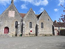
 Mairie Moriers |
||
Moriers is a French municipality with 224 inhabitants (at January 1, 2017) in the department of Eure-et-Loir in the region Center-Val de Loire ; it belongs to the arrondissement of Châteaudun and the canton of Châteaudun .
The dolmen la Pierre Couverclée (also called La Couvre-Clair) is located near Moriers.
geography
The municipality is located about 20 kilometers south of Chartres .
Population development
| year | 1962 | 1968 | 1975 | 1982 | 1990 | 1999 | 2008 | 2012 |
| Residents | 308 | 273 | 215 | 193 | 186 | 210 | 210 | 212 |
Web links
Commons : Moriers - collection of images, videos and audio files

