
Nottonville
| Nottonville | ||
|---|---|---|
|
||
| region | Center-Val de Loire | |
| Department | Eure-et-Loir | |
| Arrondissement | Châteaudun | |
| Canton | Voves | |
| Community association | Coeur de Beauce | |
| Coordinates | 48 ° 7 ′ N , 1 ° 30 ′ E | |
| height | 112-143 m | |
| surface | 24.74 km 2 | |
| Residents | 304 (January 1, 2017) | |
| Population density | 12 inhabitants / km 2 | |
| Post Code | 28140 | |
| INSEE code | 28283 | |

Nottonville is a French municipality with 304 inhabitants (as of January 1 2017) in the Eure-et-Loir in the region Center-Val de Loire ; it belongs to the arrondissement of Châteaudun and the canton of Voves (until 2015: canton of Orgères-en-Beauce ). The inhabitants are called Nottonvillois .
geography
Nottonville is about 14 kilometers northwest of Orléans . Nottonville is surrounded by the neighboring communities of Villiers-Saint-Orien in the north and west, Courbehaye in the northeast, Cormainville in the east, Bazoches-en-Dunois in the southeast, Varize in the south and southeast, Villemaury in the southwest and Conie-Molitard in the west.
Population development
| year | 1962 | 1968 | 1975 | 1982 | 1990 | 1999 | 2006 | 2013 |
| Residents | 437 | 400 | 343 | 325 | 275 | 252 | 274 | 324 |
| Source: Cassini and INSEE | ||||||||
Attractions
- Dolmen Le Palet de Gargantua
- Dolmen and polissoirs of Le Bois and Vallières
- Saint-Pierre church from the 14th century
- Former monastery Le Bois from the 10th century, since 1988 Monument historique
- La Brosse Castle, Monument historique
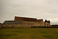
former Le Bois monastery

Path to La Brosse Castle


Web links
Commons : Nottonville - Collection of images, videos and audio files