
Suai Loro
| Suai Loro | |||

|
|||

|
|||
| Data | |||
| surface | 22.81 km² | ||
| population | 3,764 (2015) | ||
| Chefe de Suco | Martinho Mendonça (election 2009) |
||
| Aldeias | Population (2015) | ||
| Acar laran | 735 | ||
| Lo'o | 249 | ||
| Mane Icun | 646 | ||
| Sucabe laran | 528 | ||
| Suco Loro | 1,606 | ||
|
|||

Suai Loro is an East Timorese Suco in the Suai Administrative Office ( Cova Lima municipality ).
geography
| Suai Loro | ||
| places | position | height |
| Acar laran | 9 ° 21 ′ S , 125 ° 15 ′ E | 6 m |
| Audian | 9 ° 20 ′ S , 125 ° 17 ′ E | 0 m |
| Beiau | 9 ° 21 ′ S , 125 ° 17 ′ E | 0 m |
| Lo'o | 9 ° 21 ′ S , 125 ° 17 ′ E | 1 m |
| Mane Icun | 9 ° 21 ′ S , 125 ° 16 ′ E | 0 m |
| Sucabe laran | 9 ° 20 ′ S , 125 ° 16 ′ E | 1 m |
| Suco Loro | 9 ° 21 ′ S , 125 ° 16 ′ E | 0 m |
| Sularan | 9 ° 21 ′ S , 125 ° 16 ′ E | 0 m |
Before the 2015 territorial reform, Suai Loro had an area of 21.85 km². Now there are 22.81 km². The Suco is located on the Timor Sea , south of the municipality capital Suai , the center of which is nine kilometers north in the neighboring Suco Debos . To the northeast is the Suco Camenaça and to the southwest, across the Tafara River , the Tilomar administrative office with its Suco Casabauc .
The main town is Suco Loro ( Suai Loro , Sukuloro ), on Cabo Suai . In the immediate vicinity are the places Mane Icun ( Maneikun ), Lo'o ( Loo ), Beimau and Sularan ( Nularan ), a little further north Sucabe Laran ( Sucabi Laran , Sukabilaran ) and Audian (Tetum for "thorn-free bamboo"). In the center of Sucos is the village of Acar Laran ( Akarlaran ), with primary schools in Sularan, Sucabe Laran and Acar Laran. There is also a secondary school in Acar Laran. On the coast of Suai Loro lie the ruins of a Portuguese fort.
In the Suco are the five Aldeias Acar Laran , Lo'o , Mane Icun , Sucabe Laran and Suco Loro .
fauna
You can often see saltwater crocodiles in the area .
Residents
The Suco has 3764 inhabitants (2015), of which 1884 are men and 1880 are women. The population density is 165.0 inhabitants / km². There are 833 households in the Suco. Over 90% of the population name Tetum Terik as their mother tongue. Minorities speak Tetum Prasa , Bunak , Habun or Mambai .

Dancers in Suai Loro

Dignitaries in Suai Loro

Traditional tattooing on a woman from Suai


history
Severe flooding occurred in Suai Loro in late June 2013, killing three people.
politics
In the 2004/2005 elections , Manuel was elected Chefe de Suco. In the 2009 elections , Martinho Mendonça won .
Culture
As part of the ritual engagement in Suai Loro, the armpits of the bride-to-be are tattooed, making the promise of marriage valid.
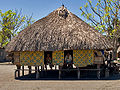
The traditional residential huts in Suai Loro are built on stilts. The outer walls are formed by hanging woven straw mats, the pattern of which indicates the clan membership of the residents. The room below the huts serves as a place of work during the day, for example for weaving the tais , the colorful fabrics that the women make at home.
- Traditional hut in Suai Loro


- Weaving tais


economy

There is a landing place for boats on Suai Loro Beach , between Cape Suai and Cape Tafara . Larger ships can also anchor safely off the coast. A supply base for the use of the oil fields off the coast is to be created here. Crude oil was also found in Suai Loro as early as the 1970s.
Web links
- Friends of Suai
- Results of the 2010 census for the Suco Suai Loro ( tetum ; PDF file; 7.96 MB)
- Results of the 2010 census for the Suco Suai Loro (tetum; PDF file)
- Seeds of Life: Suco information sheets Suai (tetum)
Individual evidence
- ↑ a b c d Direcção-Geral de Estatística : Results of the 2015 census , accessed on November 23, 2016.
- ↑ Fallingrain.com: Directory of Cities, Towns, and Regions in East Timor
- ↑ Direcção Nacional de Estatística: Population Distribution by Administrative Areas Volume 2 English ( Memento of the original from January 5, 2017 in the Internet Archive ) Info: The archive link has been inserted automatically and has not yet been checked. Please check the original and archive link according to the instructions and then remove this notice. (2010 census; PDF; 22.6 MB)
- ^ Timor-Leste GIS-Portal ( Memento from June 30, 2007 in the Internet Archive )
- ↑ Geoffrey Hull : The placenames of East Timor , in: Placenames Australia (ANPS): Newsletter of the Australian National Placenames Survey, June 2006, pp. 6 & 7, ( Memento of the original from February 14, 2017 in the Internet Archive ) Info: The archive link was inserted automatically and has not yet been checked. Please check the original and archive link according to the instructions and then remove this notice. accessed on September 28, 2014.
- ↑ a b UNMIT: Timor-Leste District Atlas version 02, August 2008 ( Memento of the original dated December 3, 2011 in the Internet Archive ) Info: The archive link was inserted automatically and has not yet been checked. Please check the original and archive link according to the instructions and then remove this notice. (PDF file; 438 kB)
- ↑ a b Cova Lima District Development Plan 2002/2003 ( Memento of the original from October 14, 2013 in the Internet Archive ) Info: The archive link was inserted automatically and has not yet been checked. Please check the original and archive link according to the instructions and then remove this notice. (English; PDF file; 2.24 MB)
- ↑ Jornal da Républica with the Diploma Ministerial n. 199/09 ( Memento of February 3, 2010 in the Internet Archive ) (Portuguese; PDF file; 315 kB)
- ↑ Results of the 2010 census for the Suco Suai Loro ( tetum ; PDF file; 7.96 MB)
- ↑ Independente: Flood in Suai, killing three local residents , June 24, 2013
- ↑ Secretariado Técnico de Administração Eleitoral STAE: Eleições para Liderança Comunitária 2004/2005 - Resultados ( Memento of August 4, 2010 in the Internet Archive )
- ↑ Secretariado Técnico de Administração Eleitoral STAE: Eleições para Liderança Comunitária 2009 - Resultados ( Memento of August 4, 2010 in the Internet Archive )
- ↑ The 4th wall: Tattooing Timor - written and researched by the Dili Collective (published in Things & Ink, issue 10) , November 22, 2015 , accessed December 16, 2015.
- ↑ Ministry of Natural Resources, Minerals & Energy Policy of Timor-Leste ( Memento from October 29, 2008 in the Internet Archive ) (English)
![]() Map with all coordinates: OSM | WikiMap
Map with all coordinates: OSM | WikiMap
The administrative borders within East Timor changed in 2015. This article must therefore be checked and updated if necessary. See New Administrative Boundaries .