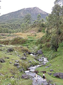
Belulik
| Belulik | ||
|
The Belulik and its tributaries run through almost the entire municipality of Ainaro |
||
| Data | ||
| location | East Timor | |
| River system | Belulik | |
| origin | Border region between the administrative offices of Maubisse and Hatu-Builico | |
| muzzle | in the Timor Sea coordinates: 9 ° 13 ′ 17 " S , 125 ° 31 ′ 54" E 9 ° 13 ′ 17 " S , 125 ° 31 ′ 54" E
|
|
| Right tributaries | Buronuno, mouth: 9 ° 7 ′ 46 ″ S , 125 ° 33 ′ 3 ″ O Cehul, mouth: 9 ° 3 ′ 56 ″ S , 125 ° 32 ′ 0 ″ E Sarai, mouth: 9 ° 3 ′ 40 ″ S , 125 ° 31 '0 " O Maumall; aperture: 9 ° 3' 40" S , 125 ° 31 '0 " O Gourete; aperture: 8 ° 56' 56" S , 125 ° 32 '0 " O Telemau; aperture: 8 ° 55 ′ 28 ″ S , 125 ° 35 ′ 0 ″ O Dare |
|
| Flowing lakes | Lagoa Oebaba | |
| Small towns | Ainaro , Cassa | |
The Belulik ( Bé-lulik , Belulic ) is a river in the south of East Timor . It has water all year round. Like the other rivers in the south of the island, the Belulik causes major floods in its estuary during the rainy season. The name Lulik means something like "holy" or "taboo" in the local language Tetum , Be means "water", the river name means "holy water".
course
The Belulik rises in the border area of the administrative offices Maubisse and Hatu-Builico between the places Airacalau and Aituto and initially flows south, but then swings to Hatu-Builico in the south-west. Here it forms the border between the Suco Mauchiga in the south and Mulo and Nuno-Mogue in the north. From Mulo the Dare meets the Belulik, then the Telemau (border river between Mulo and Nuno-Mogue) and finally the Gourete, which separates Nuno-Mogue from the Suco Manutaci ( Ainaro administrative office ). Here the Belulik swings to the south, separating Mauchiga from Manutaci, and then flowing to the southeast as the border between Soro (administrative office Ainaro) and Mauchiga. With several turns, the Belulik finally orientates itself south. On its east bank is now the Suco Leolima (administrative office Hato-Udo ), on the west bank first Soro, then Suro-Craic (administrative office Ainaro).
To the west of the main stream, several rivers have their source in the Ainaro administrative office. In the border area between the Suco Ainaro and Manutaci the Maumall, between the Suco Ainaro and Mau-Ulo the Sarai and between Soro and Suro-Craic the Cehul. Maumall and Sarai meet at the southern tip of the Sucos Ainaro, shortly afterwards the Cehul joins them. Together they form the Buronuno, which has many river islands. At the southern tip of Suro-Craic it finally flows into the Belulik, which spreads significantly here and continues to flow south between Cassa (Ainaro administrative office) and Leolima. Just a few kilometers after the town of Cassa, the municipality of Cova Lima begins on the west bank ( Zumalai administrative office , Suco Raimea ). The large river islands stretch to Lagoa Oebaba , a lake that the river runs through. To the west, a system of canals and several small lakes has formed that extends as far as the coast of Cova Lima. The Belulik itself flows into the Timor Sea near Bonuc .
Web links
Individual evidence
- ^ University of Coimbra - The geomorfology of Timor-Leste ( Memento of December 9, 2007 in the Internet Archive )
- ↑ Timor-Leste GIS Portal ( Memento from June 30, 2007 in the Internet Archive )

