
Aituto
| Aituto | |||

|
|||

|
|||
| Data | |||
| surface | 42.48 km² | ||
| population | 5,131 (2015) | ||
| Chefe de Suco | António Mendonca Paecheco (election 2016) |
||
| Aldeias | Population (2015) | ||
| Aihou | 897 | ||
| Airaca-Lau | 1,461 | ||
| Betulala | 462 | ||
| Goulolo | 302 | ||
| Hatobuti | 259 | ||
| Lebututo | 492 | ||
| Lientuto | 966 | ||
| Mau-Lefo | 88 | ||
| Russulau | 204 | ||
|
|||

The East Timorese Suco Aituto ( Aitutu ) is located in the south of the Maubisse administrative office ( municipality of Ainaro ).
geography
| Aituto | ||
| places | position | height |
| Aihou | 8 ° 53 ′ S , 125 ° 35 ′ E | 1864 m |
| Airaca-Lau | 8 ° 54 ' S , 125 ° 37' E | 1459 m |
| Anilumu | 8 ° 55 ′ S , 125 ° 39 ′ E | 1081 m |
| Fatobuti | 8 ° 51 ′ S , 125 ° 36 ′ E | 1595 m |
| Flisac | 8 ° 53 ′ S , 125 ° 36 ′ E | 1864 m |
| Goulolo | 8 ° 51 ′ S , 125 ° 36 ′ E | 1522 m |
| Kolehunu | 8 ° 52 ′ S , 125 ° 36 ′ E | 1594 m |
| Lebo | 8 ° 52 ′ S , 125 ° 35 ′ E | 1594 m |
| Lientuto | 8 ° 53 ′ S , 125 ° 36 ′ E | 1522 m |
| Manosabe | 8 ° 52 ′ S , 125 ° 36 ′ E | 1773 m |
| Russulau | 8 ° 53 ′ S , 125 ° 36 ′ E | 1756 m |

Before the 2015 regional reform, Aituto had an area of 46.91 km². Now there are 42.48 km². In the northwest are the sucos Horai-Quic and Maubisse , in the northeast Edi and in the east Manetú . In the southwest and west is the Hatu-Builico administrative office with its Sucos Mauchiga and Mulo and in the southeast the Same administrative office (municipality of Manufahi ) with its Suco Holarua . The Belulik river has its source in the southern border area with Mulo. The Colihuno forms the border to the sucos Maubisse, Edi and, as Calihuno , to Manetú. The place Goulolo is the only part of the Sucos north of the Colihuno in the "triangle" of Maubisse and Edi.
At Lientuto ( Lihentutu ), near the center of Sucos, the highways from Maubisse (and further from Aileu and Dili ), Same and Ainaro meet. On the road to Maubisse (from north to south) are the places Aihou , Flisac and Russulau ( Rusulau ), on the road to Same is the village of Airaca-Lau ( Airacalau , Airakalau ). The villages of Lebo ( Lebotutu , Lebotuto ), Kolehunu and Fatobuti are located on the south bank of the Colihuno in the north of the Sucos . Also in the north is the place Manosabe ( Manosahe ). In the northern tip of the Sucos, on the north bank of the river, lies the village of Goulolo ( Kulolo ). Anilumu is on the southeast border with Holarua. In Airaca-Lau, Lientuto and Lebo there is one elementary school each, and another on the southern tip of the Sucos. In Manosabe there is a preparatory school for the secondary level.
In Aituto there are the nine aldeias Aihou , Airaca-Lau , Betulala ( Betulata ), Goulolo , Hatobuti ( Hatubuti ), Lebututo , Lientuto , Mau-Lefo and Russulau .
Residents

5131 people live in the Suco (2015), of which 2622 are men and 2509 women. The population density is 120.8 inhabitants / km². There are 862 households in the Suco. About 95% of the population name Mambai as their mother tongue. The rest speak Tetum Prasa .
history
In an ambush by the FALINTIL in the mountains near Aituto on April 15, 1976, 54 Indonesian soldiers of the 405th Infantry Battalion who were traveling in a convoy of trucks died.
On August 20, 1982, FALINTIL fighters attacked the Hansip (civil defense) in Aituto. This was part of the Cabalaki uprising . The Indonesians immediately sent troops to the region. Houses were burned down, schools closed, and women and children were forced to keep watch in military posts. There were forced relocations, pillage, looting and rape. The military posts were set up in every aldeia in the region. FALINTIL fighters and much of the population fled the area.
In 1989, Indonesian soldiers burned the coffee plantations and forests in Suco to hunt down rebels on the mountain slopes. Villages believed to be a refuge for rebels were razed to the ground.
politics
In the 2004/2005 elections , Amandio da Silva was elected Chefe de Suco. In the 2009 elections , António Mendonca Paecheco won and was confirmed in office in 2016 .
Buildings

During the Portuguese colonial times, the Suco was known for such traditional huts, which were adorned with buffalo or goat horns at the top of the roof. There is also a white church here.
On Fleixa Pass the Holy House (located Uma Lulik ) of HIUT Lel, a cultural center of the Mambai . It is on the top of a small mountain, near a circular stone wall. The holy house in Aituto is particularly striking with its decorations. According to the local Mambai tradition, it is a round hut with a conical, thatched roof, in contrast to the otherwise rectangular holy houses in East Timor with the distinctive, steep roof.
economy
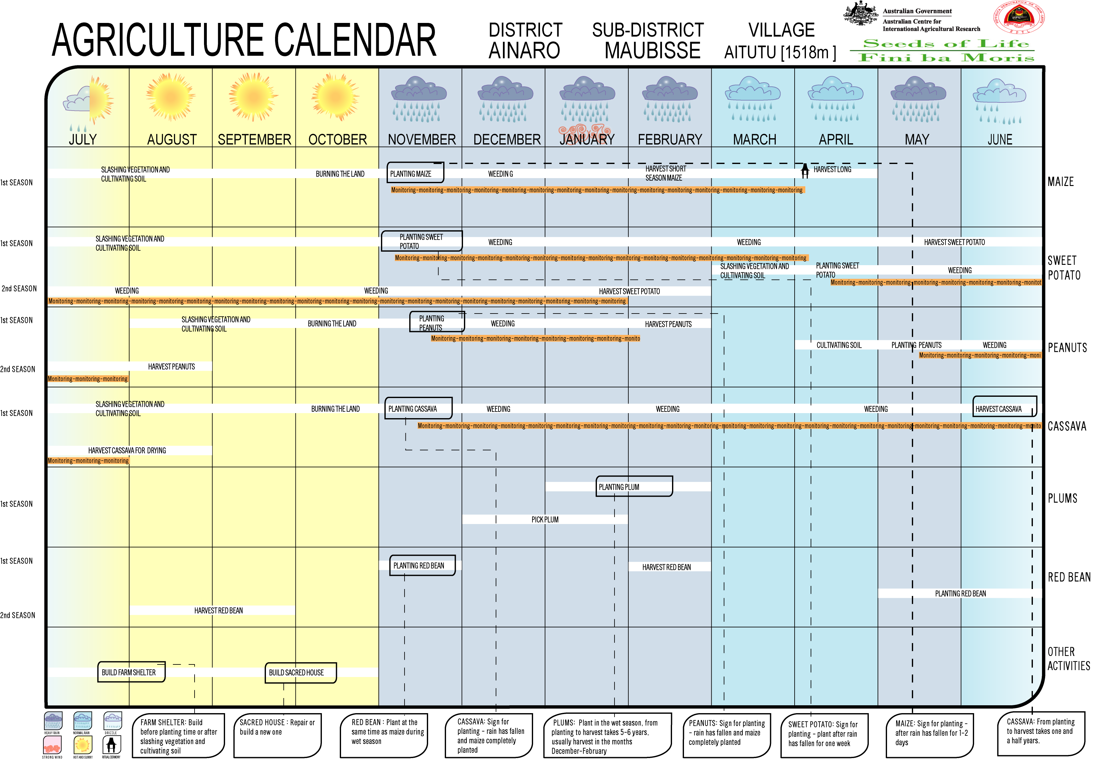
To improve the household budget, many families plant coffee. The weather on the Sucos mountain slopes is often too windy for the cultivation of the maize, which is otherwise common in northern Ainaro, which is why wheat and barley are also grown. For the harvest in August / September, sowing takes place in April or May, then again in November for the harvest in March. Food supply bottlenecks can occur in January / February in particular. In addition, beans, bananas, potatoes and taro are grown.
Web links
- Results of the 2010 census for the Suco Aituto ( tetum ; PDF; 8.2 MB)
- Results of the 2015 census for the Suco Aituto (tetum; PDF;)
- Seeds of Life: Agriculture Calendar (English)
- Seeds of Life: Suco information sheets Maubisse (tetum)
Individual evidence
- ↑ a b c d Direcção-Geral de Estatística : Results of the 2015 census , accessed on November 23, 2016.
- ↑ Fallingrain.com: Directory of Cities, Towns, and Regions in East Timor
- ↑ Direcção Nacional de Estatística: Population Distribution by Administrative Areas Volume 2 English ( Memento from January 5, 2017 in the Internet Archive ) (Census 2010; PDF; 22.6 MB)
- ^ Timor-Leste GIS-Portal ( Memento from June 30, 2007 in the Internet Archive )
- ↑ UNMIT: Timor-Leste District Atlas version 02, August 2008 ( Memento from December 3, 2011 in the Internet Archive ) (PDF; 583 kB)
- ↑ Jornal da Républica with the Diploma Ministerial n. 199/09 ( Memento of February 3, 2010 in the Internet Archive ) (Portuguese; PDF; 323 kB)
- ↑ Results of the 2010 census for the Suco Aituto ( tetum ; PDF; 8.2 MB)
- ^ Ernest Chamberlain: The Struggle in Iliomar: Resistance in rural East Timor Iliomar Sub-District , p. 121, 2017 , accessed November 6, 2018.
- ↑ "Chapter 7.4 Arbitrary detention, torture and ill-treatment" ( Memento from February 4, 2016 in the Internet Archive ) (PDF; 2.0 MB) from the "Chega!" Report of the CAVR (English)
- ↑ 6.4 Mauchiga case study: a quantitative analysis of violations experienced during counter-Resistance operations ( Memento from February 4, 2016 in the Internet Archive ) (PDF; 456 kB) from the final report of the Reception, Truth and Reconciliation Commission of East Timor (English)
- ↑ Chapter 7.7: Sexual Violence ( Memento of February 4, 2016 in the Internet Archive ) (PDF; 1.2 MB) from the final report of the Reception, Truth and Reconciliation Commission of East Timor (English)
- ↑ CSM, March 15, 1999, A free E. Timor won't be easy on ETAN
- ↑ Secretariado Técnico de Administração Eleitoral STAE: Eleições para Liderança Comunitária 2004/2005 - Resultados ( Memento of August 4, 2010 in the Internet Archive )
- ↑ Secretariado Técnico de Administração Eleitoral STAE: Eleições para Liderança Comunitária 2009 - Resultados ( Memento of August 4, 2010 in the Internet Archive )
- ↑ Jornal da República: Lista Naran Xefe Suku Eleito 2016 , December 2, 2016 , accessed on June 17, 2020.
- ↑ a b Lonely Planet Image ( page no longer available , search in web archives )
- ↑ photo of the Shrine of Fleixa , accessed on 7 December 2018th
- ^ The Living Heritage of Communities in Timor-Leste , p. 65, accessed December 7, 2018.
- ↑ Tony Wheeler, Xanana Gusmao, Kristy Sword-Gusmao: East Timor. Lonely Planet, London 2004, ISBN 1-74059-644-7
- ↑ Seeds of life ( Memento from January 7, 2011 in the Internet Archive )
![]() Map with all coordinates: OSM | WikiMap
Map with all coordinates: OSM | WikiMap
The administrative borders within East Timor changed in 2015. This article must therefore be checked and updated if necessary. See New Administrative Boundaries .