Caraulun
|
Caraulun Rio Caraulun, Ribeira Caraulun, Carau-úlun, Karau Ulun, Carau Ulun |
||
|
The source of the Colihuno lies in the north of Ainaro and the mouth of the Caraulun on the border with Manufahi. |
||
| Data | ||
| location | East Timor , Ainaro and Manufahi parishes | |
| River system | Caraulun | |
| Drain over | Timor Sea → Pacific Ocean | |
| origin | as Colihuno in Horai-Quic 8 ° 52 ′ 6 ″ S , 125 ° 33 ′ 14 ″ E |
|
| Source height | 2112 m | |
| muzzle | in the Timor Sea coordinates: 9 ° 11 ′ 37 ″ S , 125 ° 42 ′ 2 ″ E 9 ° 11 ′ 37 ″ S , 125 ° 42 ′ 2 ″ E
|
|
| Left tributaries | Rio Sui , Markis, Coliuno, Calihuno | |
| Right tributaries | Ermerin, Caloco, Moussamau, Aiasa | |
| Medium-sized cities | Seed | |
| Small towns | Dai-Sua , Turiscai | |
| Communities | Ca , Turon | |
| UNI : 9012783 | ||
|
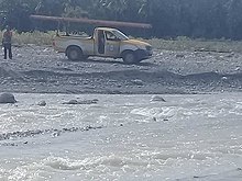
The Caraulun at Dai-Sua |
||
The Caraulun ( Rio Caraulun , Ribeira Caraulun , Carau-úlun , Mota Carau Ulun , Mota Karau Ulun , German Buffalo Head River ) is a river in southern East Timor .
Origin of name
Legend has it that two boys were led by a dog in search of water to a buffalo head that was buried in the ground. When the boys pulled their heads out of the ground, a spring gushed out from underneath and formed today's river.
Source rivers, tributaries and course

In Suco Horai-Quic ( Office of Administration Maubisse , community (East Timor) community Ainaro ) rises near the village Ca of Colihuno . It continues east through the Maubisse administrative office before flowing as Calihuno into the Same administrative office ( Manufahi municipality ). At the border, the Markis joins the Calihuno from the north. In Same, the Calihuno forms the border between the Sucos Tutuluro and Holarua , later between Tutuluro and Letefoho . When the Suco Tutuloro merges into the Suco Babulo on the east bank , the river flowing to the southwest already bears its name Caraulun, which it now leads to the mouth.
At the border between Letefoho and Babulo, the Ermerin flows into the Caraulun from the west. Manufahi's capital, Same , is located on the Ermerin , the largest town on the river system. The Caraulun then swings south again and crosses the Suco Babulo. At the town of Turon the Caloco flows into the Caraulun from the west and shortly before the Caraulun flows into the Suco Dai-Sua , its largest tributary, the Rio Sui , reaches it from the east .
The Sui has several headwaters. The northernmost has its source near Turiscai in Suco Manumera ( Turiscai administrative office , Manufahi municipality), to the west of it rises the Carbou , tributary of the Sui tributary Aicocai and the Aicocai in Suco Maulau (Maubisse administrative office). Further tributaries come from the Sucos Mindelo and Beremana (both administrative office Turiscai). Coming from the administrative office Turiscai, the Sui flows further south and forms the border between Same in the west and the administrative offices Fatuberlio and Alas in the east, until the Sui flows into the center of Same and meets the Caraulun.
In the Caraulun River south of town empties Dai-Sua of Aiasa , the border river between the towns of Ainaro and Manufahi. It arises from the Moussamau river , which rises in the west of Letefoho. After the confluence of the Aiasa and Caraulun, the Caraulun now forms the border river between the communities. It expands and forms many small river islands until the Caraulun finally flows into the Timor Sea east of the Ponta Lalétec .
Web links
Individual evidence
- ↑ Matthew Libbis BA (Hons) Anthropology: Rituals, Sacrifice & Symbolism in Timor-Leste , accessed February 18, 2015.

