
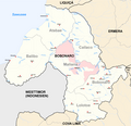
Bobonaro (Municipality)
|
Munisípiu Bobonaru (tetum) Município de Bobonaro (port.) |
||||||||||||||||||||||
  |
||||||||||||||||||||||

|
||||||||||||||||||||||
| Data | ||||||||||||||||||||||
| Capital | Maliana | |||||||||||||||||||||
| surface | 1,378.10 km² (5.) | |||||||||||||||||||||
| Population (2015) | 97,762 (4.) | |||||||||||||||||||||
| Population density | 70.94 inhabitants / km² (7.) | |||||||||||||||||||||
| Number of households (2015) | 17,635 (4.) | |||||||||||||||||||||
| ISO 3166-2 | TL-BO | |||||||||||||||||||||
| Administrative offices | Residents | surface | ||||||||||||||||||||
| Atabae | 10,963 | 251.84 km² | ||||||||||||||||||||
| Balibo | 15,922 | 295.97 km² | ||||||||||||||||||||
| Bobonaro | 24,719 | 212.50 km² | ||||||||||||||||||||
| Cailaco | 10,405 | 208.02 km² | ||||||||||||||||||||
| Lolotoe | 6,845 | 172.72 km² | ||||||||||||||||||||
| Maliana | 28,908 | 237.04 km² | ||||||||||||||||||||
| map | ||||||||||||||||||||||

|
||||||||||||||||||||||
Bobonaro ( tetum Bobonaru ) is a municipality in East Timor . It is named after its former capital, Bobonaro . The name is derived from the Tetum word "Buburbnaru" and means "large eucalyptus ". The community is located on the north coast of Timor and borders the neighboring state of Indonesia in the west . Bobonaro is shaped by the river system of the Lóis , in whose plains rice is grown. In the south the mountains rise to a height of 1500 m . In 1975, Bobonaro was one of those regions of East Timor that were occupied by the Indonesians before the open invasion began on December 7th. Five western journalists, the " Balibo Five " , were also killed .
geography
overview

Since the territorial reform of 2015, Bobonaro has an area of 1378.10 km² (previously 1380.82 km²). Capital of the municipality is 149 km southwest of the state capital Dili located Maliana . Bobonaro is divided into the six administrative offices Atabae , Balibo , Bobonaro , Cailaco , Lolotoe and Maliana .
The municipality of Bobonaro is located in the northwest of East Timor on the Sawu Sea . Coming from West Timor , the Nunura River runs through the municipality from south to north and finally flows into the Lóis , which forms the border to the municipality of Liquiçá in the northeast and partly to the municipality of Ermera in the east . The source rivers of the Nunura, Talau and Malibaka, form a large part of the border with the Indonesian West Timor, which belongs to the province of East Nusa Tenggara , in the west . The Bulobo coming from the east flows into the Nunura, where Maliana, Atabae and Cailaco meet. In the southeast, Bobonaro shares a short stretch of border with the municipality of Ainaro . To the south is the municipality of Cova Lima . Mota'ain , the most important border crossing between East Timor and Indonesia, is located near the coastal town of Batugade .
Bobonaro consists of three levels. The lowland plain in the northwest consists of barren land and rice fields and takes up the space from the coast to Nunura. In the west a plain extends up to a height of 1000 m . The highland plain extends to 1500 m . The highest mountains in the municipality are the Tapo ( 1934 m ), the Leolaco ( 1929 m ), the Leohito ( 1925 m ), the Leber ( 1403 m ) and the Tulo ( 1285 m ). Bobonaro was a popular destination in colonial times because of its cool mountains and hot springs. Nine percent of the community area is forested. On the coast is the 27,848 hectare Important Bird Area des Be Malae ( German Malae Lake ) and Atabae , which consists of forests and wetlands.
From November to March there is over 1000 mm of precipitation in the rainy season. Lolotoe has the largest annual rainfall in the country at 2837 mm. In the seven months of the dry season it hardly rains. Generally the temperatures are between 18 and 32 ° C. With increasing altitude, the temperature drops by about 0.5 ° C per 100 m .
Places and rivers in Bobonaro
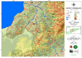
Road network and topography of Bobonaro

Rice growing areas in Bobonaro

Climate diagram of Atabae

Climate diagram of Maliana


fauna
In the last few years, like elsewhere on the Lesser Sunda Islands, black- scarred toads ( Bufo melanostictus ) have also immigrated to Bobonaro. Native frogs are the white-bearded rowing frog ( Polypedates leucomystax ) and not classified representatives of the rice frogs ( Fejervarya ).
The largest representative of the geckos in Bobonaro is the tokeh ( Gekko gecko ). There is also the Indo-Pacific gecko ( Hemidactylus cf. garnotii ), the four- clawed gecko ( Gehyra mutilata ) and an unspecified bow-finger gecko ( Cyrtodactylus sp.). The Elbert emerald skink ( Lamprolepis smaragdina cf. elberti ) is strikingly green .
The island pit viper ( Trimeresurus insularis ) is a local venomous snake, towards the coast the hooded wolf tooth snake ( Lycodon capucinus ) and dog-headed water snake ( Cerberus schneiderii ) are known.
Residents


97,762 inhabitants live in the municipality (2015, 2011: 96,709 inhabitants). The population density is 70.94 inhabitants per square kilometer. The administrative offices of Bobonaro and Maliana are more densely populated. The sucos Holsa and Ritabou are classified as " urban ". The average age is 18.9 years (2010).
In 2004, each woman in Balibo had an average of 6.17 children, the number rose to over 6.46 in Lolotoe, 6.53 in Maliana, 6.60 children in Atabae and 7.19 children in Bobonaro up to 8.32 children per woman in Cailaco (national average 6.99). Between 1990 and 2004 the number of inhabitants grew by 0.16% annually. However, many residents migrate to other parts of the country, especially to the state capital Dili. Over 8,000 residents of Dilis were born in Bobonaro. In 2002, the infant mortality rate in Balibo was 94 deaths per 1000 live births (1996: 110), in Maliana 106 (121), In Atabae 109 (87), Lolotoe 117 (145), Cailaco 118 (109) and in Bobonaro at 149 (179). The national average was 98. Atabae and Cailaco are thus two of 14 administrative offices in which, contrary to the national trend , child mortality increased. Bobonaro is one of the eight government offices with the highest child mortality rates in the country.
44.3% of the population speak the national language Kemak as their mother tongue . 25.1% speak Bunak (the largest language group can be found in the administrative offices of Bobonaro, Lolotoe and Maliana), 25.7% Tetum, 4.1% Bekais (in the administrative office of Balibo). If the second languages are also taken into account, in 2015 92.3% spoke Tetum, 37.6% Bahasa Indonesia, 30.2% Portuguese and 12.2% English .
The southeast of Bobonaro, together with the northeast of Cova Lima, forms the heartland of the Bunak . Here they usually make up a majority of the population of over 90% within the sucos. In the northeast of the heartland, the Bunak even use the words Gaiq or Gaeq as a self-name for themselves and their language , which is derived from Mgai , the foreign name used by the Kemak. According to the oral tradition of the local Bunak, they formerly belonged to the kingdom of Likusaen (Likosaen) , which with today's Liquiçá had its center in the area of the Tokodede and Kemak. This realm is said to be responsible for the strong linguistic influence of the Kemak on the language of the Bunak. Only a few generations ago the Bunak immigrated to the lowlands, south of Maliana, from the highlands, mixed with the Tetum and Atoin Meto who lived there and founded several villages. Here, too, they form the majority of the population. In the northern part of Maliana and a large part of Balibo, Tetum Prasa is mainly spoken, while to the south there are minorities with Tetum Terik as their mother tongue. In the southeast of Balibo, Bekais is spoken by the majority and the Kemak dominate the entire north of the municipality. They make up the majority in the administrative offices of Atabae, Balibo and Cailaco. In Marobo and Obulo , Kemak mixed with the local Bunak. This led to cultural differences between the Kemak and their neighbors in Atsabe .
In 2004, 99.6% of the population were Catholics , 0.2% followers of the traditional, animistic religion of Timor , 0.1% Protestants and 0.2% Muslims . The 2015 census counted 99.7% Catholics, 0.17% Protestants, 0.08% Muslims and only 21 animists.
In 2015, 36.5% of residents aged three or over attended school. 26.8% had left school. 35.3% have never attended school, which is more than 6% above the national average. 5.4% of Bobonaro's residents only attended pre-school, just under a third only attended primary school. Secondary schools have completed a fifth of the population. Only 3.0% can show a diploma or a degree; here, too, the numbers are worse than the national average. The illiteracy rate in 2015 was 23.3% (women: 22.6%; men: 24.0%). In 2004 it was still 64.1%.
| Education | Graduation | ||||||||||
| at school | Finished school | never in a school | Preschool | primary school | Pre- secondary |
Secondary | Diploma / University of Applied Sciences |
university | No graduation | ||
| Women | 35.4% | 24.5% | 38.7% | 5.2% | 29.6% | 10.7% | 9.8% | 0.4% | 1.9% | 0.9% | |
| Men | 37.6% | 29.1% | 31.9% | 5.6% | 33.5% | 10.2% | 11.3% | 0.8% | 2.9% | 0.9% | |
| total | 36.5% | 26.8% | 35.3% | 5.4% | 31.5% | 10.4% | 10.5% | 0.6% | 2.4% | 0.9% | |
history
Colonial times
.jpg)

.svg)
In the 17th century the Portuguese built a large fortress in Balibo and a smaller fort in Batugade in 1655 to protect their colonial claims on Timor. While the fort in Batugade served as a notorious prison in the 20th century, the fort in Balibo remained a military post and administrative seat until the Portuguese withdrew in 1975.
In the area of today's Bobonaro there were originally at least eight traditional Timorese empires ruled by Liurais . Balibo, Cailaco, Cowa, and Sanirin appear on a list by Afonso de Castro , a former governor of Portuguese Timor who listed 47 empires in 1868. The Cowas Empire stretched from the north coast to the territory of the Dutch West Timor . The Portuguese fort in Batugade was also in the Cowas area. The kingdom of Lamaquitos (Lamakitu) ruled roughly the area of today's administrative office Maliana, between Cailaco in the north and Maucatar in the south. Other empires were Bobonaro and Ayasa . In the north of Bobonaro was the small Kemak empire of Marobo , which was under the domination of the empire of Atsabe (municipality of Ermera), on whose western periphery it lay.
According to oral tradition, the north of Bobonaro was under the rule of the kingdom of Likusaen (Likosaen) , which with today's Liquiçá had its center in the area of the Tokodede and Kemak. The dominance of Likusaen can still be recognized today by the strong linguistic influence of the Kemak on the language of the Bunak. Likusaen was in competition with the Tetum empire of Wehale in the southeast of what is now Indonesia's West Timor. During the later colonial division of Timor between the Dutch and Portuguese, the Wehales areas fell to the Netherlands, while Portugal took the areas of Likusaen under its sovereignty. However, there were still some border shifts, also because the various Timorese empires repeatedly fought wars against each other, which resulted in changing dependencies. The border, which now separates Indonesia and East Timor, still divides the settlement area of the Bunak, Tetum, Kemak and Bekais.
In the 18th century there was the Cailaco rebellion against the Portuguese. Cailaco was considered the main base of the rebels. At that time, 40,000 people lived relatively isolated in the Marobo Valley with the Marobo and Lóis rivers . The Pedras de Cailaco (Rock of Cailaco), the steep walls of the Leolaco, offered the empire of Cailaco a natural fortress and were considered impregnable. On October 23, the Portuguese gathered a total of 4,000 men at the foot of the mountain, including Topasse and allied Timorese. After 40 days, however, they had to give up the siege in December, also due to heavy rain.
In 1865, Balibo united with the Cowa Empire to fight the Portuguese. In Cotubaba ( Tutubaba ?) Near Batugade there was an attack on Portuguese troops by Timorese warriors. In 1868 the Portuguese sent a force to Sanirin, whose liurai refused to pay taxes, and from Batugade an offensive against Cowa and Balibo began . Cailaco supported the colonial power with its own warriors. In 1871 the Queen of Balibo, Dona Maria Michaelia Doutel da Costa, surrendered . Balibo became a vassal of Portugal. Cowa did not recognize the supremacy of Portugal until 1881. The ruler of Atabae and the Liurai of Maubara rebelled against the colonial rulers in 1893 . For Atabae, the Maubara revolt ended with an ultimatum from the Portuguese. On July 14, the ruler of Atabae agreed, swore allegiance to the king of Portugal and had to pay compensation in the form of money, buffalo and pigs.
The ruler of Atabae, together with the Liurai of Maubara, rebelled against the Portuguese colonial rulers in 1893 . In March 1895, Governor José Celestino da Silva led an offensive against Marobo to finally subdue it for Portugal. In 1896 Atabae supported the Manufahi Empire in another war against the Portuguese . The well-known Portuguese officer Francisco Duarte was killed during the siege of Atabae .
In early 1961, the left-wing Office for the Liberation of Timor (Bureau de Luta pela Libertação de Timor) attempted an uprising. On April 9, it proclaimed a republic in Batugade and established a Timorese government. The Portuguese quickly put down the uprising and the fighters fled to Indonesia.
Occupation by Indonesia


On October 8, 1975, Indonesian troops occupied the border town of Batugade in what was then Portuguese Timor and set up their headquarters for Operation Komodo here . They pretended to be fighters from the UDT , which had previously been defeated by FRETILIN in the power struggle. Maliana followed on October 14, and the remainder of the then sub-district of Balibo followed on October 16. Among the victims here were two British and three Australian reporters in Balibo Vila , the so-called Balibo Five . In the coastal town of Aidabaleten (Atabae), FRETILIN fighters under Aquiles Freitas Soares resisted. From mid-November the Indonesians fired at Aida balets from the sea. On November 26th, the East Timorese stopped the resistance. The Indonesians occupied the place on the morning of November 28th.
FRETILIN made an appeal to the UN Security Council , but the international community did not intervene. On November 28th, FRETILIN declared East Timor independent from Portugal , but on December 7th, Indonesia openly began the invasion of East Timor , initially sparing the rest of Bobonaro. In Cailaco and the neighboring regions, bases de apoio were created , in which the refugee civilian population was settled by the FALINTIL resistance movement . Between September 1977 and February 1978 the Indonesian army also advanced into the hinterland of Bobonaro. The resistance bases were destroyed, the residents were dispersed or captured. Massive human rights violations occurred during the occupation and the associated guerrilla warfare of the Timorese. One of the so-called "Rape Houses" was located in Lolotoe, in which the Indonesians committed mass rapes of East Timorese women.
A referendum was held in 1999 in which the people of East Timor voted for independence from Indonesia. Before and especially after that, there was a wave of violence across the country , triggered by six pro-Indonesian militias and the Indonesian military . The city of Maliana was stormed by pro-Indonesian militias. Two United Nations drivers were killed and the whole place, except for the church, burned down. On September 8, there was a massacre in the Maliana police station , in which at least 13 people died. In the entire Bobonaro district at that time, at least 111, possibly over 200 people were murdered in September 1999. The Lolotoe sub-district, where the Kaer Metin Merah Putih (KMP) militia fought with the Indonesian military, was particularly hard hit . Only after the intervention of the international intervention force INTERFET under Australian leadership did the violence end. On October 16, 1999, in Aidabasalala (Suco Hataz ), there was a skirmish between six Australian INTERFET soldiers and around 20 members of a pro-Indonesian militia. Three militiamen were killed and three others were injured. East Timor came under UN administration and was given independence in 2002.
Independent East Timor

An Indonesian soldier was injured in an exchange of fire on April 21, 2005 near Maliana between Indonesian soldiers and East Timorese police officers from the Unidade de Patrulhamento de Fronteira (UPF).
On January 6, 2006, three Indonesians were shot dead by East Timorese police on the border near the Indonesian Turiskain on the Malibaca River . According to Indonesian military sources, the three victims were fishing when fire opened on them without warning. Jakarta protested violently. Following the incident, East Timorese women were raped.
In early 2010 there were reports that gunmen disguised as ninjas terrorized the populations in Cova Lima and Bobonaro. East Timorese Police (PNTL) and Army (F-FDTL) then sent units to take action against the criminals. 118 people were captured in the action, seven of them arrested.
On January 30, 2010, Maliana was declared the seat of the third diocese of East Timor .
In 2014, the districts across East Timor were transformed into "parishes" and the sub-districts into "administrative offices".
politics

|
District President (Bupati) |
|
| João da Costa Tavares ( UDT ) | May 1976-1989 |
| Mariano Lopes da Cruz (UDT) | 1989-1992 |
| Guilherme dos Santos ( APODETI ) | 1992 (?) - 1999 |
|
Civil Administrator |
|
| João Vicente | until 2002 |
|
Administrador |
|
| Leonel de Jesus Carvalho | from 2002 |
| Domingos Martins | current (as of 2014) |
The administrator of Bobonaro is appointed by the state government in Dili. Under UN administration, this was João Vicente until 2002 , followed by Leonel de Jesus Carvalho. It is currently Domingos Martins (as of February 2014).

In the elections to the constituent assembly , which later became the national parliament, FRETILIN won 57.42% of the vote in Bobonaro, so that it received the direct mandate at that time. In the 2007 parliamentary elections , the Congresso Nacional da Reconstrução Timorense (CNRT) succeeded in becoming the strongest force in Bobonaro with 20.6% of the vote. In the parliamentary elections in 2012 , the CNRT was able to build on its success with 37.7% of the vote. In 2017 , the CNRT in Bobonaro only got 32.4%, but still became the strongest force in the community. In the early elections in 2018 , the Aliança para Mudança e Progresso (AMP) , to which the CNRT now belonged, received 50.9% of the vote.
In the first round of the 2007 presidential elections , Fernando de Araújo from the Partido Democrático (PD) in Bobonaro received 38.7% of the vote, but was eliminated as third place nationwide. In the second round, the non-party José Ramos-Horta won 84.6%. In 2012 Fernando de Araújo won again in Bobonaro, but had to admit defeat again in fourth place nationwide. The second round in Bobonaro went to election winner Taur Matan Ruak with 70.0%. In the 2017 presidential election in Bobonaro, the nationwide winner Francisco Guterres from FRETILIN won the most votes.
Symbols

The communities of East Timor have no legal symbols. However, the Bobonaros profile from 2012 of the Direksaun Nacional Administrasaun Local names the head of a horse as a symbol of the community. On the one hand, it is often said that horse meat is very popular in Bobonaro, and on the other hand, the Portuguese 5th Cavalry Squadron was stationed here in the colonial times . In addition, the shape of Bobonaro on the map is reminiscent of a horse's head.
Culture
At least every four years there is a fishing festival on Lake Malai (Be Malae) , in which the kingdoms of Balibo and Atabae take part. The date varies, but generally falls on August 29th and 30th.
Economy and Infrastructure
| Share of households with ... | ||
| agriculture | ||
| Field crops | Share 2010 | Production 2008 |
| Corn | 66% | 10,600 t |
| rice | 31% | 16,662 t |
| manioc | 57% | 3,667 t |
| coconuts | 55% | not specified |
| vegetables | 46% | 2,563 t (with fruit) |
| coffee | 28% | not specified |
| Livestock | ||
| Livestock | Share 2010 | Number of animals 2010 |
| Chicken | 77% | 76.602 |
| Pigs | 78% | 40,565 |
| Bovine | 43% | 29,235 |
| Water buffalo | 11% | 7,559 |
| Horses | 11% | 3,345 |
| Goats | 32% | 18,010 |
| Sheep | 2% | 2,060 |
| Furnishing | ||
| Furnishing | Share 2010 | Number of households |
| radio | 27% | 4,549 |
| watch TV | 15% | 2,476 |
| Telephone (mobile / landline) | 50% | 8,412 |
| fridge | 4% | 705 |
| bicycle | 7% | 1,238 |
| motorcycle | 13% | 2.120 |
| automobile | 5% | 432 |
| boat | 3% | 467 |


According to the 2010 census, 43% of all residents who are ten years or older work (national average: 42%). 4% are unemployed (5%). 72.3% of households practice arable farming, 88.5% cattle (as of 2010). On the coasts, fishing is the main source of income for the population. Carp , catfish , Mozambique cichlid (mujair) and snakehead fish (gabus) are also bred here. 66% of households grow maize (national average: 55%), 55% coconuts (42%), 57% manioc (51%) and 46% vegetables (43%). Over 31% plant rice (25%), especially in Maliana and Cailaco on the east bank of the Nunura and on the Bulobo. Peanuts, green beans, mung beans , kidney beans, soy, cassava and sweet potatoes are also grown for basic supplies . In addition, the residents plant mustard leaves, lettuce, cabbage, onions, carrots, bananas, tomatoes, aubergines, papayas, pineapples, potatoes and garlic. Chickens are primarily kept as pets. Over three quarters of households have chickens, and a little more have pigs. Cattle are found in 43% of households, one in three keeps goats, one in ten keeps horses or buffalo. Sheep are rare. Bad harvests lead to massive problems, for example in November 2007 there was an extreme food shortage in Balibo.
28% of households grow coffee for sale, which is the national average. Other commodities are light nuts , coconuts, oranges, mangos and other fruits. The coffee center in the community is the high administrative office Lolotoe, where over 76% of households grow the country's most important export product. In Cailaco and Bobonaro it is still between 47 and 45%.
93% of Bobonaro's households live in their own home, with a further 4% owning a family member outside the household. Just under a quarter of all residential buildings are made of brick or concrete. The majority of the buildings are still made of natural materials such as bamboo, palm fronds or clay. Zinc and iron sheets have prevailed in many places for roofs. However, 29% of the houses are still covered with palm fronds or thatch. In more than half of the houses, the floor consists of rammed earth, in 35% of concrete or tiles. Overall, the natural materials in Bobonaro are as widespread as in other countries. 74% of households have access to clean drinking water sources (10% above the national average), with only 21% having the water on or in the house. The residents of the other households have to get the drinking water from public pipes, wells, springs or bodies of water. At 94%, almost all households use wood for cooking. The national average is 4% less. Almost two thirds use kerosene to generate light and a quarter use electricity. In the national average, half use petroleum and over a third use electricity.
Natural gas, crude oil, gold and silver are found in smaller quantities as mineral resources. In Atabae, salt is extracted from the sea.
Tourist attractions include Lake Malai , the beaches of Palaca and Batugade, the fortress of Balibo and the Australian House of the Balibo Five. The hot springs of the Termas do Marobo , the water of which is collected in a swimming pool, were already a popular destination during the Portuguese rule . There are still some colonial ruins here. The Maliana Colegio Infante de Sagres offers study courses.
In 2010, 5% of households in Bobonaro had cars and 13% motorcycles. The A03 runs north from Maliana through Marko and Atabae, to the municipality of Liquiça. The A12 starts in Maliana towards the east to Bobonaro . From there the A12 leads south to Zumalai and northwards the A10 to Atsabe . The A16 connects Bobonaro with Lolotoe and Fatululic . Maliana has an airfield.
The communal radio station in the parish is Radio Communidade Maliana RCM (Radio Maliana) on FM 91.7 MHz. Less than a third of all households own a radio. Only 15% have a television.
| Share of households with ... | ||||||||
| ... house walls made of ... | ||||||||
| Brick / concrete | Wood | bamboo | Clay | Iron / zinc sheet | Palm fronds | Natural stones | Others | |
| 24% | 3% | 11% | 5% | 2% | 51% | 4% | 1 % | |
| ... roofs made of ... | ... floors made of ... | |||||||
| Palm fronds / straw / bamboo | Iron / zinc sheet | Roof tiles | Others | concrete | Tiles | Soil / loam | Bamboo / wood | Others |
| 29% | 70% | 1 % | 0% | 31% | 4% | 60% | 3% | 2% |
| Drinking water supply through ... | ||||||||
| Pipe or pump in the house | Line or pump outside | Public pipeline, well, borehole | protected source | unprotected source | Surface water | Others | ||
| 3% | 18% | 35% | 18% | 18% | 6% | 2% | ||
| Energy source for cooking | Light source | |||||||
| electricity | petroleum | Wood | Others | electricity | petroleum | Wood |
Light nut / candle berry |
Others |
| 1 % | 4% | 94% | 1 % | 24% | 64% | 3% | 3% | 6% |
Partnerships
Web links
- District profile 2012 (tetum; PDF)
- Ministry of State Administration and Territorial Management
- Bobonaro District Development Plan 2002/2003, April 2002 ( Memento of March 28, 2009 in the Internet Archive ) (PDF; 566 kB)
- Geoffrey C. Gunn: History of Timor. Technical University of Lisbon (PDF; 805 kB)
Individual evidence
- ↑ a b c d e f g h i j k l m n o Direcção-Geral de Estatística : Results of the 2015 census , accessed on November 23, 2016.
- ↑ Geoffrey Hull : The placenames of East Timor , in: Placenames Australia (ANPS): Newsletter of the Australian National Placenames Survey, June 2006, pp. 6 & 7, ( Memento of February 14, 2017 in the Internet Archive ). September 2014.
- ↑ a b c d Direcção Nacional de Estatística: 2010 Census Wall Chart (English) ( Memento from August 12, 2011 in the Internet Archive ) (PDF; 2.7 MB)
- ↑ a b Bobonaro District Development Plan 2002/2003, p. 5.
- ↑ Bobonaro District Development Plan 2002/2003, p. 25
- ↑ BirdLife International: Sites - Important Bird and Biodiversity Areas (IBAs): Be Malae-Atabae , accessed March 12, 2015.
- ↑ Mark O'Shea et al. a .: Herpetological Diversity of Timor-Leste Updates and a Review of species distributions. In: Asian Herpetological Research. 2015, 6 (2): pp. 73-131., Accessed on July 17, 2015.
- ↑ Direcção Nacional de Estatística: Timor-Leste in figures 2011 (PDF; 3.8 MB) ( Memento from February 19, 2014 in the Internet Archive ), accessed on May 5, 2013
- ↑ a b Census of Population and Housing Atlas 2004 ( Memento of November 13, 2012 in the Internet Archive ) (PDF; 14 MB)
- ↑ a b c d Antoinette Schapper: Finding Bunaq: The homeland and expansion of the Bunaq in central Timor ( Memento of the original from October 24, 2013 in the Internet Archive ) Info: The archive link was inserted automatically and has not yet been checked. Please check the original and archive link according to the instructions and then remove this notice. , Pp. 163–186, in: Andrew McWilliam, Elizabeth G. Traube: Land and Life in Timor-Leste: Ethnographic Essays , 2011
- ↑ a b cf. Numbers and references in the individual articles
- ^ Andrea K. Molnar: Died in the service of Portugal.
- ↑ District Priority Tables: Bobonaro 2004 ( Memento from 20131113164300) (PDF; 14.8 MB)
- ↑ a b TRADITIONAL POWER STRUCTURES AND THE COMMUNITY EMPOWERMENT AND LOCAL GOVERNANCE PROJECT. In: studylib.net. August 11, 1975, accessed March 15, 2019 .
- ↑ TIMOR LORO SAE - Um pouco de história ( Memento from 20160208202347)
- ^ East Timor ( Memento of February 21, 2004 in the Internet Archive )
- ^ Gunn, p. 86.
- ↑ Timorlorosae 2000 (Portuguese)
- ^ Center for Southeast Asian Studies, Northern Illinois University
- ↑ Gunn, pp. 42-43.
- ↑ Gunn, p. 88.
- ^ The case of Alferes Francisco Duarte “O Arbiru” (1862–1899) (PDF; 386 kB), accessed on March 25, 2013
- ↑ Jolliffe, Jill. East Timor: Nationalism and Colonialism . Queensland: University of Queensland Press, 1978. OCLC 4833990
- ^ ETAN, When East Timor first flew its flag in defiance
- ^ Center for Southeast Asian Studies, Northern Illinois University
- ^ ETAN: When East Timor first flew its flag in defiance
- ↑ "Chapter 7.3 Forced Displacement and Famine" ( Memento of November 28, 2015 in the Internet Archive ) (PDF; 1.3 MB) from the "Chega!" Report of the CAVR (English)
- ↑ Inventory of the investigation of the past in Indonesia and East Timor
- ↑ Tagesspiegel, September 3, 1999, attack on UN employees in Maliana 1999 ( Memento of March 11, 2007 in the Internet Archive )
- ↑ Bobonaro District Development Plan 2002/2003 p. 32.
- ↑ 1999 East Timor Crimes against humanity ( Memento of February 2, 2010 in the Internet Archive )
- ↑ Citation.com: Sydney Morning Herald, March 25, 2000, Gallantry award for sergeant who led bloody timor battle
- ↑ Sukehiro Hasegawa: Routledge Revivals: Peacebuilding and National Ownership in Timor-Leste (2013) . limited preview in Google Book Search, April 21, 2005
- ↑ Tempointeractive, January 6, 2006, Three Indonesians Shot by Timor Leste Police ( Memento from January 18, 2012 in the Internet Archive )
- ↑ Wikinews, March 24, 2010, “Ninjas” in Timor-Leste?
- ↑ January 30, 2010, Catholic News Agency, Benedict XVI erects new diocese in East Timor
- ↑ "Part 4: Regime of Occupation" (PDF; 563 kB) from the "Chega!" Report of the CAVR (English)
- ↑ Bobonaro District Development Plan 2002/2003, p. 2.
- ↑ World Bank: Participation List Timor-Leste and Development Partners Meeting 3-5 December 2003 , accessed April 27, 2020.
- ^ Descentralização Administrativa na República Democrática de Timor-Leste: Bobonaro , accessed on February 7, 2014
- ↑ Lurdes Silva-Carneiro de Sousa: Some Facts and Comments on the East Timor 2001 Constituent Assembly Election ( Memento of October 16, 2013 in the Internet Archive ) ( RTF ; 199 kB), Lusotopie 2001: pp. 299–311.
- ↑ CNE - official results on 9th July 2007 ( Memento from September 27, 2007 in the Internet Archive ) (PDF; 118 kB)
- ↑ CNE: CNE 2017
- ↑ CNE: Munisipios , accessed May 30, 2018.
- ^ Profile of the Bobonaro District 2012: 2.2. Simbolu Distritu Bobonaro , p. 15.
- ↑ Margaret JE King: Fishing Rites at Be-Malai, Portuguese Timor (report of a visit in August 1960), Records of the South Australian Museum, Adelaide, Sth Aust. : Govt. Printer, "From Records of the South Australian Museum, Vol. 15, No. 1, October 6, 1965."
- ↑ a b c d e f g h i j k l m n Direcção Nacional de Estatística: Suco Report Volume 4 (English) ( Memento from April 9, 2015 in the Internet Archive ) (PDF; 9.8 MB)
- ↑ a b Direcção Nacional de Estatística: Timor-Leste in Figures 2008 ( Memento of 7 July 2010 in the Internet Archive ) (PDF; 3.6 MB)
- ↑ Bobonaro District Development Plan 2002/2003, p. 22.
- ↑ Bobonaro District Development Plan 2002/2003, pp. 10-11.
- ↑ Press release of the Ministry of Agriculture, Forestry and Fishery, November 21, 2007.
- ↑ Bobonaro District Development Plan 2002/2003, p. 11.
- ↑ Bobonaro District Development Plan 2002/2003, p. 12
- ^ Road map of East Timor, 2001.
- ↑ UNMIT: Timor-Leste District Atlas version 02, August 2008 ( Memento of November 8, 2012 in the Internet Archive ) (PDF; 535 kB)
- ↑ ARKTL - Asosiasaun Radio Komunidade Timor-Leste (English)
- ↑ Municípios Portugueses: Geminações de Cidades e Vilas , accessed on January 7, 2018.
- ↑ Municípios Portugueses: Geminações de Cidades e Vilas , accessed on January 7, 2018.
Coordinates: 9 ° 2 ′ S , 125 ° 20 ′ E