
Balibo Vila
| Balibo Vila | |||

|
|||

|
|||
| Data | |||
| surface | 39.54 km² | ||
| population | 3,933 (2015) | ||
| Chefe de Suco | Domingos de Asis (election 2016) |
||
| Aldeias | Population (2015) | ||
| Amandato | 2,199 | ||
| Atara | 421 | ||
| Balibo Vila | 458 | ||
| Belola | 80 | ||
| Builekun | 18th | ||
| Fatuk laran | 326 | ||
| Fatululik | 431 | ||
|
|||

Balibo Vila (short Balibo or Balibó ) is the main town and a suco of the East Timorese administrative office of the same name, Balibo ( municipality of Bobonaro ).
Place name
“Baliboo” is the Tetum word for “heron”. The addition “Vila” means “village” in Tetum and “small town” in Portuguese , but is not used consistently. During the Indonesian occupation, “Vila” was replaced by the term “Kota”, for “city” in Bahasa Indonesia .
The place
Balibo is located about 10 km from the Indonesian border in the far north-west of the country at an altitude of 547 m . Districts are Airae , Aube , Balibo , Dad Brille , Fatukuak , Fatululik ( Fatululic , Fatululit ), Minereng and Misi .
The place has a primary school, a secondary school preparation school, a helipad and a community health center. The Indonesian “Integrationsdenkmal” ( Integrasi monument ) is still located on the main square . It depicts a Timorese peasant breaking the shackles of Portuguese colonial rule and holding a flag. The fort of Balibo , a 400 year old colonial fortress, is also located in the village . The local church is dedicated to Saint Anthony.

The town of Balibo as seen from the fortress

The market

A microlet on the sacred tree in front of the market


The Suco
| Balibo Vila | ||
| places | position | height |
| Airae | 8 ° 58 ′ S , 125 ° 3 ′ E | 547 m |
| Aitos | 8 ° 57 ′ S , 125 ° 4 ′ E | 569 m |
| Aube | 8 ° 58 ′ S , 125 ° 3 ′ E | 624 m |
| Balibo | 8 ° 58 ′ S , 125 ° 2 ′ E | 547 m |
| Beain | 8 ° 58 ′ S , 125 ° 3 ′ E | 569 m |
| Belola | 8 ° 57 ′ S , 125 ° 4 ′ E | 349 m |
| Berame | 8 ° 58 ′ S , 125 ° 3 ′ E | 624 m |
| Builekun | 8 ° 57 ′ S , 125 ° 4 ′ E | 514 m |
| There | 8 ° 58 ′ S , 125 ° 3 ′ E | 547 m |
| Fatukakae | 8 ° 58 ′ S , 125 ° 2 ′ E | 354 m |
| Fatuk laran | 8 ° 59 ′ S , 125 ° 3 ′ E | 578 m |
| Fatukuak | 8 ° 58 ′ S , 125 ° 3 ′ E | 547 m |
| Fatululik | 8 ° 58 ′ S , 125 ° 2 ′ E | 615 m |
| Fatunisin | 8 ° 57 ′ S , 125 ° 4 ′ E | 514 m |
| Fatuteke | 8 ° 57 ′ S , 125 ° 2 ′ E | 321 m |
| Lasulets | 8 ° 57 ′ S , 125 ° 4 ′ E | 349 m |
| Malibican | 8 ° 57 ′ S , 125 ° 4 ′ E | 349 m |
| Malilets | 8 ° 56 ′ S , 125 ° 3 ′ E | 311 m |
| Minereng | 8 ° 58 ′ S , 125 ° 3 ′ E | 624 m |
| Misi | 8 ° 58 ′ S , 125 ° 2 ′ E | 547 m |
| Raihun | 8 ° 59 ′ S , 125 ° 3 ′ E | 646 m |


Balibo Vila has 3933 inhabitants (2015), of which 1891 are men and 2042 women. The population density is 99.5 inhabitants / km². There are 744 households in the Suco. Over 40% of the population state Kemak as their mother tongue. About 30% speak Tetum Prasa , over 15% speak Bekais , about 10% speak Tetum Terik and a small minority speak Bunak .
Before the 2015 territorial reform, Balibo had an area of 34.90 km². Now there are 39.54 km². The Suco is located in the center of the Balibo Administrative Office. In the west is the Suco Batugade , in the northwest Sanirin , in the north Leolima , in the east and south Leohito and in the southeast Cowa .
The Laecouken rises in the north of the Sucos and forms part of the border with Leohito. The Kolosuma rises in the border area to Batugade , which later forms the Leometik with the Motak . The place Balibo is near the center of Sucos on the highway from Batugade to Maliana , which runs from west to east through the middle of the Suco. East of Balibo are on the road the places Berame , Beain , Aitos , Fatunisin , Belola ( Belota ) and Lasuleten west Fatukakae . In the northeast there are also the villages of Builekun ( Builecon , Bui Lecun , Bilekun ) and Malibikan , in the north Malilets , in the west Fatuteke and in the south Raihun and Fatuk Laran ( Fatuc Laran , Fatuklaran ).
There are several caves around Balibo. Duanele is the largest cave in Balibo and is open to visitors. The cave of Gruta Morutau is considered sacred and only a few village elders are allowed to visit. Here is a shrine of Mary where a mass is held at Easter.
In Suco Balibo Vila there are the seven Aldeias Amandato , Atara , Balibo Vila , Belola , Builekun , Fatuk Laran and Fatululik .
history
Colonial times

Balibo was one of the traditional Timorese empires ruled by Liurais . It appears on a list by Afonso de Castro , a former governor of Portuguese Timor who listed 47 empires in 1868.
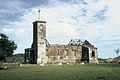
Ruins of the Balibo Church, destroyed in World War II (1970)
Fort of Balibo


Indonesian occupation

At the beginning of October 1975, Indonesia began occupying the Portuguese Timor border areas. These incursions by Indonesia served in preparation for the actual invasion on December 7, 1975. The defense of Balibo was taken over by Francisco Ruas Hornay , a former soldier in the Portuguese colonial army . The colonial fortress became the site of several skirmishes, but on October 16, Balibo fell. On that day, five foreign television journalists, the so-called Balibo Five , were murdered by Indonesian soldiers in the village . From the old fortress they filmed the entry of Indonesian armed forces. The so-called "Australian Flag house" on the main square, on which the reporters had painted the flag of Australia to indicate their neutral status, was converted into a community center with funds from the Australian state of Victoria .
In the Balibo Declaration , the leaders of the East Timorese parties UDT , APODETI , KOTA and the Partido Trabalhista condemned the declaration of independence of East Timor by FRETILIN on November 28, 1975 and called for the country to join Indonesia. However, the declaration was drafted by the Indonesian secret service and signed in Bali by East Timorese politicians who were practically in captivity. The Balibo Declaration was later used by the Indonesian government to justify the occupation of East Timor. Xanana Gusmão , who later became the first President of East Timor after the Indonesian occupation, called it the Balibohong Declaration , a play on the Indonesian word for "lie".
According to estimates by Human Rights Watch , around 70% of Balibo Vila was destroyed by militias in the wave of violence surrounding the independence referendum in East Timor in 1999 . International aid organizations helped rebuild the village, for example the school dormitory for students from remote villages, which was completely destroyed.
Balibo in liberated East Timor

During the INTERFET mission ( International Force for East Timor ) the fortress was used as a base by 1000 UN troops after the Indonesian withdrawal in 1999 . In the same year Kylie Minogue gave a concert for the UN members as part of her Tour of Duty series of concerts .
politics
In the 2004/2005 elections , Abel da Cruz was elected Chefe de Suco. In the 2009 elections Domingos de Assis Soares won and in 2016 Domingos de Asis .
See also
Web links
- Results of the 2010 census for the Suco Balibo ( tetum ; PDF; 8.5 MB)
- Results of the 2015 census for the Suco Balibo (tetum; PDF)
- Seeds of Life: Suco information sheets Balibo (tetum)
- The Balibo Declaration ( Memento of October 27, 2005 in the Internet Archive ) (English)
- Report on an aid convoy to Balibo in 2000
Individual evidence
- ↑ a b c d Direcção-Geral de Estatística : Results of the 2015 census , accessed on November 23, 2016.
- ↑ Geoffrey Hull : The placenames of East Timor , in: Placenames Australia (ANPS): Newsletter of the Australian National Placenames Survey, June 2006, pp. 6 & 7, ( Memento of February 14, 2017 in the Internet Archive ). September 2014.
- ↑ a b UNMIT: Timor-Leste District Atlas version 02, August 2008 ( Memento of the original from November 8, 2012 in the Internet Archive ) Info: The archive link was inserted automatically and has not yet been checked. Please check the original and archive link according to the instructions and then remove this notice. (PDF; 535 kB)
- ↑ Fallingrain.com: Directory of Cities, Towns, and Regions in East Timor
- ↑ Results of the 2010 census for the Suco Balibo ( tetum ; PDF; 8.5 MB)
- ↑ Direcção Nacional de Estatística: Population Distribution by Administrative Areas Volume 2 English ( Memento of the original from January 5, 2017 in the Internet Archive ) Info: The archive link has been inserted automatically and has not yet been checked. Please check the original and archive link according to the instructions and then remove this notice. (2010 census; PDF; 22.6 MB)
- ^ Timor-Leste GIS-Portal ( Memento from June 30, 2007 in the Internet Archive )
- ↑ Jornal da Républica with the Diploma Ministerial n. 199/09 ( Memento of February 3, 2010 in the Internet Archive ) (Portuguese; PDF; 323 kB)
- ↑ TIMOR LORO SAE, Um pouco de história ( Memento of the original dated November 13, 2001 in the Internet Archive ) Info: The archive link was inserted automatically and has not yet been checked. Please check the original and archive link according to the instructions and then remove this notice.
- ↑ East Timor - PORTUGUESE DEPENDENCY OF EAST TIMOR ( Memento of February 21, 2004 in the Internet Archive )
- ↑ Secretariado Técnico de Administração Eleitoral STAE: Eleições para Liderança Comunitária 2004/2005 - Resultados ( Memento of August 4, 2010 in the Internet Archive )
- ↑ Secretariado Técnico de Administração Eleitoral STAE: Eleições para Liderança Comunitária 2009 - Resultados ( Memento of August 4, 2010 in the Internet Archive )
- ↑ Jornal da República: Lista Naran Xefe Suku Eleito 2016 , December 2, 2016 , accessed on June 17, 2020.
![]() Map with all coordinates: OSM | WikiMap
Map with all coordinates: OSM | WikiMap
The administrative borders within East Timor changed in 2015. This article must therefore be checked and updated if necessary. See New Administrative Boundaries .