Lolotoe
| Lolotoe | ||
|---|---|---|
|
|
||
| Coordinates | 9 ° 10 ′ S , 125 ° 16 ′ E | |

|
||
| Basic data | ||
| Country | East Timor | |
| Bobonaro | ||
| Administrative office | Lolotoe | |
| ISO 3166-2 | TL-BO | |
| Suco | Deudet and Grandpa | |
| height | 807 m | |
| Residents | - | |
| Metropolitan area | 3454 (2006) | |
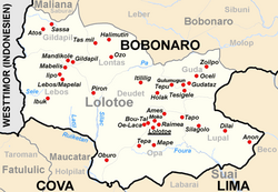
Lolotoe ( Lolotoi, Lolo-Toe ) is the main town of the administrative office of Lolotoe ( municipality of Bobonaro ) in northwest East Timor . 3454 inhabitants live in the village (2006).
geography
Lolotoe is located in the southeast of the municipality of Bobonaro at an altitude of 807 m above sea level in the Sucos Deudet and Opa . The settlement center also includes the places Raimea and Moko in Opa and Bou Valley and Oe-Laca in Suco Deudet. The administrative seat of the administrative office is in Deudet. It is about 78 km to the northeast to the state capital Dili as the crow flies, and about 18 km to the north to the municipal capital Maliana . It is only a few kilometers to the border with Indonesia .
Lolotoe has a microclimate, so that the largest annual rainfall in East Timor is registered here with 2837 mm per year.
There are two primary schools, two schools preparing for secondary school, a helipad and a community health center.
history
In 1999 in East Timor, which was then occupied by Indonesia, there was a wave of violence by pro-Indonesian militias ( Wanra ) and the Indonesian military who wanted to decide the upcoming independence referendum in favor of the occupiers. At the end of May, the then sub-district of Lolotoe was also affected. There have been arbitrary arrests, abuse, rape, torture and murder.
Indonesian soldiers and members of the Kaer Metin Merah Putih (KMP) militia rounded up members and alleged supporters of the CNRT , the umbrella organization of the East Timorese independence movement. Many were beaten and tortured. Women were raped in a named rape house . In 2005, a mass grave was found in Lolotoe with 30 supporters of independence who were killed here.
Individual evidence
- ^ Timor-Leste GIS-Portal ( Memento from June 30, 2007 in the Internet Archive )
- ↑ Jornal da República : Diploma Ministerial no 24/2014 de 24 de Julho - Orgânica dos Postos Administrativos ( Memento of March 4, 2016 in the Internet Archive )
- ^ Asian Development Bank: TIM: District Capitals Water Supply Project - Rehabilitation of Lake Lehumo , September 2011 , accessed February 23, 2014.
- ↑ UNMIT: Timor-Leste District Atlas version 02, August 2008 ( Memento of the original from November 8, 2012 in the Internet Archive ) Info: The archive link has been inserted automatically and has not yet been checked. Please check the original and archive link according to the instructions and then remove this notice. (PDF; 535 kB)
- ↑ 1999 Crimes against humanity in East Tiomor ( Memento of February 2, 2010 in the Internet Archive )
