
Mota'ain
| Mota'ain | |||
|---|---|---|---|
|
|||
| Coordinates | 8 ° 58 ′ S , 124 ° 57 ′ E | ||
 Mota'ain is on the coast, on the border with Indonesia Mota'ain is on the coast, on the border with Indonesia
|
|||
| Basic data | |||
| Country | East Timor | ||
| Bobonaro | |||
| Administrative office | Balibo | ||
| ISO 3166-2 | TL-BO | ||
| Suco | Batugade | ||
| height | 69 m | ||
 The first boundary stone between East Timor and Indonesia
|
|||

Mota'ain ( Motaain, Mota Ain, Mota'in ) is a village in East Timor , which is grouped around the most important, official border crossing to the Indonesian West Timor .
Mota'ain is located in Suco Batugade ( Balibo Administrative Office , Bobonaro municipality ). From Mota'ain it is 2.5 km east to Batugade and 115 km to the state capital Dili . To the west it is 9 km to Atapupu and 25 km to Atambua .
There is a helicopter landing pad in the village.
On August 30, 2005, three years after East Timor's independence, the foreign ministers of both neighboring countries laid the first official boundary stone in Mota'ain. The border is formed by a small river, which flows into the Sawu Sea and from which the place owes its name. Mota means “river” in the local language Tetum and Mota'ain “lower river” or “river mouth” .

Border crossing in Mota'ain to Indonesia

East Timorese border post in Mota'ain (2012)
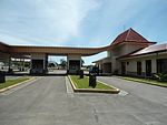
East Timorese border post in Mota'ain (2012)

East Timorese border post in Mota'ain (2009)


Web links
Individual evidence
- ↑ a b UNMIT map of the Bobonaro district, August 2008 ( memento of the original from November 8, 2012 in the Internet Archive ) Info: The archive link was inserted automatically and has not yet been checked. Please check the original and archive link according to the instructions and then remove this notice. (PDF; 535 kB)
- ↑ Progress report of the Secretary-General on the United Nations Office in Timor-Leste (for the period 16 Aug 2005 to 13 Jan 2006) (S / 2006/24) ( Memento of the original from October 16, 2014 in the Internet Archive ) Info : The archive link was inserted automatically and has not yet been checked. Please check the original and archive link according to the instructions and then remove this notice. , January 17, 2006
- ^ Dictionary Tetum - English
- ↑ Geoffrey Hull : The placenames of East Timor , in: Placenames Australia (ANPS): Newsletter of the Australian National Placenames Survey, June 2006, pp. 6 & 7, ( Memento of the original from February 14, 2017 in the Internet Archive ) Info: The archive link was inserted automatically and has not yet been checked. Please check the original and archive link according to the instructions and then remove this notice. accessed on September 28, 2014.