
Administrative division of Vietnam
The Socialist Republic of Vietnam is the Constitution of 2013 and Article 2 in accordance with Article 110 of the Law on the structure of the local administration ( Luat Tō Chuc Chính Quyền DJIA Phương ) in administrative units divided on three levels:
- Provincial level ( Cấp Tỉnh ):
- 58 provinces ( Tỉnh )
- 5 cities directly under central government ( Thành phố trực thuộc trung ương )
- County level: ( Cấp Huyện ):
- 47 (urban) districts ( Quận )
- 556 counties ( Huyện )
- 46 market towns ( Thị xã )
- 10 provincial cities ( Thành phố trực thuộc tỉnh )
- 0 cities subordinate to a city under central government ( Thành phố thuộc thành phố trực thuộc trung ương )
- Municipal level ( Cấp Xã ):
- 9,121 municipalities ( Xã )
- 1,366 Neighborhoods ( Phường )
- 625 large municipalities ( Thị trấn ).
Furthermore, there are further divisions within communities such as làng , thôn , bản , buôn and sóc ; within districts and large parishes there are khu dân cư , khu phố , khu vực, and khóm . However, these do not have their own administrative authorities.
Administrative authorities
At all three levels there is a people's council ( Hội đồng nhân dân ) as a legislative body, elected by the voters who live in the respective administrative unit . This elects a people's committee ( Ủy ban nhân dân ) as the executive body .
People's Council
Every People's Council has a board of directors, which is formed by the chairman and his / her deputy. These are elected by the delegates of the People's Council. The board has a number of functions, including representing the council externally when there are no meetings. Special committees are set up to deal with specific problems. All provinces have an economic and budget committee, a social and cultural committee, and a legal committee. In provinces with large numbers of people who are not ethnic Vietnamese, there is usually an ethnic affairs committee.
Citizens can vote in elections for the People's Council when they have reached the age of 18. Citizens from the age of 21 have the right to vote. You can either nominate yourself for election or be selected and set up by the Vietnamese Patriotic Front . The nominated candidates are voted on at a so-called electoral conference organized by the Fatherland Front. The participants of this conference decide, partly by secret ballot, partly by a show of hands, whether the candidates meet the criteria set by the People's Council. Only those candidates who are trusted by the electoral conference are eligible to vote.
The number of candidates per constituency is between one and three. There must be more candidates than seats in the People's Council in each constituency.
People's Committee
The People's Committee is the executive arm of the government. It is responsible for the implementation of political decisions. The people's committee usually has a president, a vice-president and between nine and eleven members.
List of provinces
The most populous administrative unit in Vietnam is Ho Chi Minh City , one of the five cities that are directly subordinate to the central government and are therefore formally equivalent to a province. Officially, over eight million people live in the municipality. The second most populous administrative unit, and thus the most populous area province, is Thanh Hóa , with more than three and a half million people.
Lai Châu Province in the remote mountainous northwest of the country has the lowest population .
The largest province in terms of area is Nghệ An , which extends from the city of Vinh up the wide Song Ca valley. The smallest province is Bắc Ninh in the densely populated Red River Delta .
|
||||||||||||||||||||||||||||||||||||||||||||||||||||||||||||||||||||||||||||||||||||||||||||||||||||||||||||||||||||||||||||||||||||||||||||||||||||||||||||||||||||||||||||||||||||||||||||||||||||||||||||||||||||||||||||||||||||||||||||||||||||||||||||||||
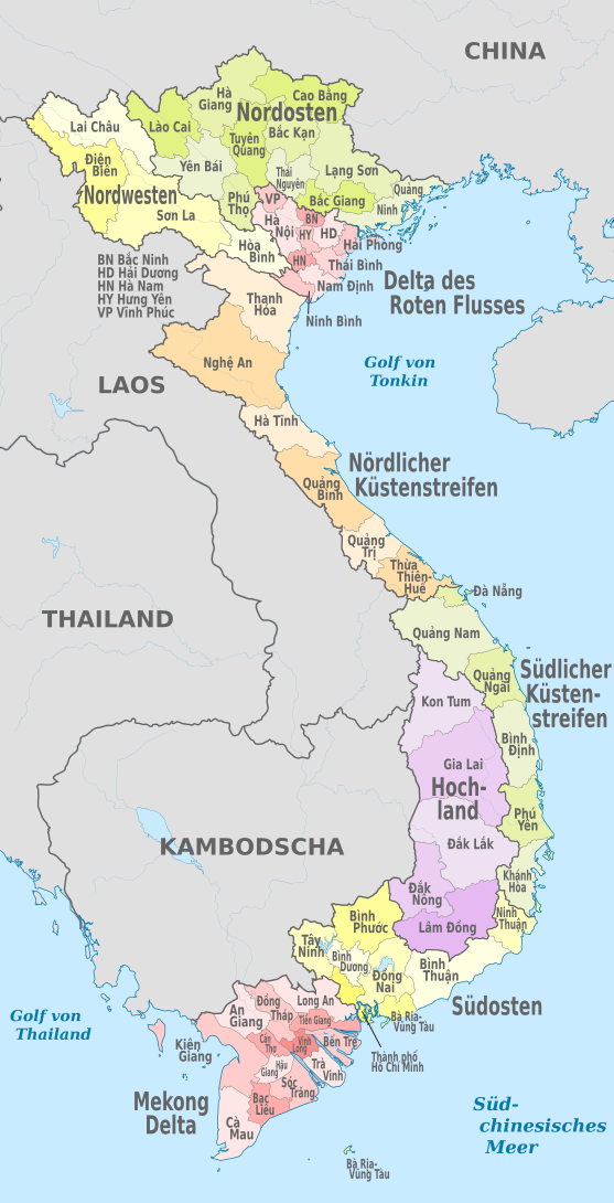
Map of the provinces
The map below shows the Vietnamese provinces and cities that are equivalent to the provinces; Status at the end of 2003. The changes made in November 2003 (ie the creation of Điện Biên and Đắk Nông provinces and the division of Can Thơ province into the city of Can Thơ and Hậu Giang province ) have already been taken into account.
_-_de_-_colored.svg)
Population density of Vietnamese provinces
The provinces of Vietnam are shown on the map with their population density. The most densely populated are the delta of the Red River and the Mekong . Most of the provinces there have more than 500 inhabitants / km². Most of the provinces of Vietnam have a population density of no less than 100 people / km²

Web links
- Decentralization of government power in Vietnam (Cardozo Electronic Law Bulletin)
- Provinces of Vietnam (Vietnam Tourism)
- Provinces of Vietnam (city population)
- News about Vietnam
Individual evidence
- ↑ Chính quyền địa phương, Hiến pháp 2013
- ↑ Luật Tổ chức chính quyền địa phương
- ↑ a b c d e f g h Số đơn vị hành chính có đến 31/12/2009 phân theo địa phương
- ↑ Vietnam: Provinces, Cities & Urban Communities - Population Statistics, Maps, Charts, Weather and Web Information. Retrieved May 5, 2018 .
Afghanistan | Egypt | Armenia | Azerbaijan | Bahrain | Bangladesh | Bhutan | Brunei | China | Georgia | India | Indonesia | Iraq | Iran | Israel | Japan | Yemen | Jordan | Cambodia | Kazakhstan | Qatar | Kyrgyzstan | Korea, North Korea | Korea, South Korea | Kuwait | Laos | Lebanon | Malaysia | Maldives | Mongolia | Myanmar | Nepal | Oman | East Timor | Pakistan | Philippines | Russia | Saudi Arabia | Singapore | Sri Lanka | Syria | Tajikistan | Thailand | Turkmenistan | Turkey | Uzbekistan | United Arab Emirates | Vietnam | Cyprus
Administrative division of the States of:
Africa |
Asia |
Australia and Oceania |
Europe |
North and South America