Red river
|
Red River Hóng Hé / Sông Hồng / Yuan Jiang |
||
|
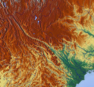
The catchment area of the Sông Hồng |
||
| Data | ||
| location | Yunnan ( PR China ), Vietnam | |
| River system | Red river | |
| Headwaters | Yunnan Province 25 ° 50 ′ 0 ″ N , 101 ° 19 ′ 0 ″ E |
|
| Source height | 1776 m | |
| muzzle |
Gulf of Tonkin ( South China Sea ) Coordinates: 20 ° 16′15 ″ N , 106 ° 33′46 ″ E, 20 ° 16′15 ″ N , 106 ° 33′46 ″ E |
|
| Mouth height | 0 m | |
| Height difference | 1776 m | |
| Bottom slope | 1.5 ‰ | |
| length | 1149 km | |
| Catchment area | 170,977 km² | |
| Drain |
MNQ MQ MHQ |
700 m³ / s 3640 m³ / s 30,000 m³ / s |
| Left tributaries | Nanxi He , Clear River (Sông Lô) | |
| Right tributaries | Black River (Sông Đà) | |
| Big cities | Hanoi , Hải Phòng , Nam Định , Việt Trì | |
| Navigable | from Việt Trì | |
|
Red River in Yunnan (China; April 2002) |
||
|
Sunset on the Red River, view from the Long Biên Bridge (Hanoi, Vietnam) |
||
|
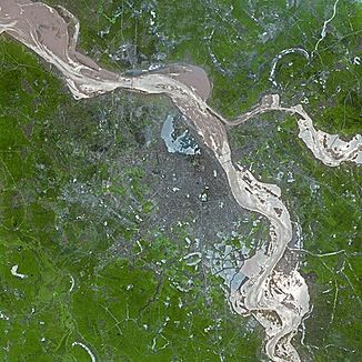
Run of the Red River through Hanoi |
||
|
Middle reaches and delta of the Red River |
||
The Red River ( Chinese 紅河 / 红河 , Pinyin Hóng Hé and Vietnamese Sông Hồng or Hồng Hà ) or Yuan Jiang ( Chinese 元 江 , Pinyin Yuán Jiāng ) is a river system in southern China and northern Vietnam .
Geography and geology
The total length of the river is 1149 km ; 639 km of this are in the People's Republic of China and 510 km in the territory of the Socialist Republic of Vietnam. This length has fluctuated greatly over the course of the earth's history, for example the sea level was about 4,000 years ago about 5 to 6 meters higher, so that the mouth was west of Hanoi (Higham 1989) .
The amount of sediment that has always been carried along has increased significantly in recent years due to deforestation , intensive cultivation and high soil erosion in the catchment area and is currently around 10,000,000 t annually, i.e. H. 1.5 kg per m³ of water. This results in a strong soil application and a growth of the delta by approx. 100 m per year. The Red River is also notorious for its strong seasonal fluctuations in the amount of water and its heavy flooding.
Since the eleventh century, these conditions have forced the Vietnamese to contain the river system with dykes, which today are designed for a water flow between 49,000 and 57,000 m³ / s. The highest value to date of 37,000 m³ / s was measured in 1945. The diked river bed is now partly higher than the surrounding land. The maximum tidal range on the coast of the delta is approx. 4 m. If the Intergovernmental Panel on Climate Change ( IPCC) predicts that sea levels will rise, the entire delta, which is only between 1 m and 3 m above sea level, is at risk.
Name interpretation
The sediments carried along by u. a. Iron oxide, reddish-brown colored water gives the river its name.
Name variants:
- 红河 / 紅河 "Red River"
- 元 江 "Original River"
- Mandarin (Pinyin): Yuán Jiāng , Cantonese (Jyutping): jyun 4 gong 1
- Sông Hồng / Hồng Hà "Pink River"
- Sông Cái "mother river"
- Sông Nhị / Nhị Hà "Two rivers" - for the section that flows through Hanoi
- Lalsa baqma
- earlier German inscription also
- Songkoi, Sang-koi, Songkai, Song-ka, Yüan-chiang
River course
Source and upper course
The Red River has its source in the north of the southern Chinese province of Yunnan at an altitude of 1776 m. The headwaters are a mountain range southwest of the city of Dali in the autonomous district of the same name . The upper course has washed the river valleys into deep gorges. Flowing in a south-easterly direction, the Red River crosses the autonomous areas of the Dai peoples (mainly Yi , Hani and Miao ) to the Honghe Autonomous District . The name Hóng Hé for the river gave the district its name.
Over a section of around 50 kilometers, the Red River marks the Sino-Vietnamese state border. At the city of Lào Cai in the Vietnamese province of Lào Cai, the river crosses the border and reaches the Tonkin landscape (Vietnamese Bắc Bộ, "northern border"). The Vietnamese also call the section of the river from here to Việt Trì Sông Thao .
Middle course
At Yên Bái, the river enters the North Vietnamese lowlands . The main tributary of the Black River (Sông Đà) also rises in Yunnan and runs parallel to the Sông Hồng to the south. It flows into the main river between Tam Thanh and Việt Trì in the province of Phú Thọ. The Red River is navigable from Việt Trì. There the second major tributary, the Clear River (Sông Lô), flows in from the north. The section from here to Hanoi is also called Nhị Hà . Past Sơn Tây, the river flows southeast through the capital Hanoi.
Red River Delta
Main article: Đồng Bằng Sông Hồng
120 km off the coast, east of Hanoi in the direction of the city of Thuận Thành, the river divides into two main courses to continue to flow north as Sông Đuống and south as Sông Hồng. From here the Red River widens to its confluence with the Gulf of Tonkin to form a delta with an area of approx. The delta gives the Vietnamese region "Delta of the Red River" ( Đồng Bằng Sông Hồng ) its name.
On a northern branch of the Sông Đuống called Cua Cam ( Forbidden Door ) lies Hải Phòng , the most important port city in Northern Vietnam. South of Nam Định , the main course of the river flows into the Gulf of Tonkin (Vietnamese Vịnh Bắc Bộ, Chinese 北部 湾 Beibu Wan).
Provinces and counties
Chinese districts of Yunnan Province in the Red River catchment area:
Dali , Pu'er City , Chuxiong , Yuxi City , Honghe , Wenshan
Vietnamese provinces:
Lào Cai , Yên Bái , Phú Thọ , Vĩnh Phúc , Hà Nội , Hưng Yên , Hà Tây , Nam Định , Hà Nam , Thái Bình
meaning
The Delta is the region of origin of the Kinh people . With 15% of the Vietnamese population, the region is one of the most densely populated in the world.
history
The legend that the Red River, in contrast to the Mekong , is navigable up to the upper reaches and therefore suitable for trade with China, influenced France's interest in North Vietnam in the 19th century ( see also: Vietnam under French colonial rule ).
The region was heavily bombed during the Vietnam War .
economy
In the middle reaches there are several important hydropower plants, the performance of which decreases continuously due to the landfall of the river bed.
The delta with its fertile sediment deposits is a major area of agricultural production in Vietnam. About 47% of the area (820,800 hectares) is agricultural land, on which more than a third of the country's rice production is grown. The irrigation and drainage takes place through a sophisticated system of dams, dykes and canals. The total length of the dikes, which are up to 40 m wide at the base, is more than 3000 km today, and there are often traffic routes on the crowns.
environment
The Red River Delta was included in the UNESCO MAB program as a biosphere reserve in 2004 . Various multinational commissions, such as the Flocods ( FLOod COntrol Decision Support ) project, deal with the threats to the river system and its delta .
See also
literature
- Maren, Bas van: Morphodynamics of a cyclic prograding delta: the Red River, Vietnam . Royal Dutch Geographical Society, Utrecht 2004, ISBN 90-6809-363-0
- Hoekstra, Piet van Weering, Tjeerd CE: Morphodynamics of the Red River Delta, Vietnam . Journal of Asian earth sciences; Vol. 29 (2007), ISSN 1367-9120
Web links
References
- ^ Charles Higham: The Archeology of Mainland Southeast Asia . Cambridge University Pr., 1989, ISBN 0-521-27525-3
- ↑ Dieter Brötel: French Imperialism in Vietnam - Colonial Expansion and the Establishment of the Annam-Tongking Protectorate 1880 - 1885 . Atlantis-Verlag, Zurich [u. a.] 1971


