
Long Biên Bridge
Coordinates: 21 ° 2 ′ 36 ″ N , 105 ° 51 ′ 32 ″ E
| Long Biên Bridge | ||
|---|---|---|
 |
||
| Official name | Cầu Long Biên | |
| use | Railway bridge , road bridge | |
| Crossing of | Red river | |
| place | Hanoi | |
| construction | Cantilever Bridge , steel - truss | |
| overall length | 1682.60 m | |
| Longest span | 106.20 m | |
| height | 13.5 m | |
| start of building | 1899 | |
| completion | 1902 | |
| opening | February 28, 1903 | |
| planner | Daydé et Pillé | |
| location | ||
|
||

The Long Biên Bridge (Vietnamese: Cầu Long Biên , historically also Paul Doumer Bridge ) is a cantilever road and rail bridge ( cantilever bridge ) over the Red River in northern Vietnam . It connects Long Biên , the only city district ( Quận ) of the capital Hanoi on the east bank of the river, with the districts of Hoàn Kiếm and Ba Đình in the center of the historic old town. The bridge was planned by the company Établissements Daydé et Pillé and built from 1899 to 1902. Because of its strategic importance, it was hotly contested in the Vietnam War .
Planning and construction

The northernmost section of the Hanoi-Ho Chi Minh City railway line |
|||||||||||||||||||||||||
For the French colonial government, the construction of the first steel bridge over the Red River was of great strategic importance in order to secure control over North Vietnam . The building project was approved by the colonial administration on June 4, 1897. The company Établissements Daydé et Pillé of the engineer Henri Daydé and his nephew, the structural engineer Auguste Pillé , also took part in the following tender . The company is based in Creil and is now part of Eiffage Métal . Daydé & Pillé prevailed against the five contracting construction companies with their design B, a 19-step cantilever construction with 20 pillars, and a cost calculation of 5,390,794 francs . The construction time was estimated at five years. The company Société de construction de Levallois-Perret , renamed Compagnie des établissements Eiffel on the occasion of the departure of its founder Gustave Eiffel on February 14, 1893 , failed with its offer. Contrary to popular belief, Eiffel was not the designer of the bridge.
The groundbreaking ceremony took place on September 12, 1898, and construction was completed after just 3 years and 9 months. From 1899 to 1902, more than 3000 Vietnamese and a team of 40 French site managers and engineers were employed. There were numerous accidents on the construction site, some of which resulted in death. 30,000 m³ of material were used, including 5600 tons of rolled steel, 137 tons of cast iron, 165 tons of iron and 7 tons of lead. The construction costs amounted to 6.2 million francs. With a spanned length of 1.68 kilometers, the Long Biên Bridge was the longest bridge in Indochina around 1900 and one of the four longest ever. It spans a river width of 896 m and has a total length with access roads of 2.29 km. Due to the layout of the driveways, traffic on the bridge is on the left .
On February 28, 1903, the first train drove the Emperor Thành Thái , the former Governor General of French Indochina Paul Doumer , initiator and namesake of the building, and his successor in office, Paul Beau, from Hanoi station to the inauguration event, which was attended by thousands of visitors . Until the Japanese occupation of Hanoi in 1940, the bridge was named after Paul Doumer ( pont Paul-Doumer or pont Doumer ). The term Cầu Sông Cái or Cầu sắt sông Cái was popularly used, which translates as an (iron) bridge over the Mother River . After the dissolution of the French civil administration, the Japanese occupying power transferred the administration of Hà Nội, Hải Phòng and Đà Nẵng to the Trần Trọng Kim government on July 20, 1945 . Trần Văn Lai was appointed mayor of Hanoi , who looked for Vietnamese equivalents for a variety of French names and designations and renamed the bridge to Cầu Long Biên . After the Việt Minh invaded Hanoi on October 10, 1954, this name became official.
Strategic importance
The bridge closed the last major gap on the Hanoi – Ho Chi Minh City railway line between Hanoi and Gia Lâm, so that the south of Vietnam was connected to the border region with China. It created the connection to the Yunnan Railway , which reaches the Chinese border at Lào Cai in the north , and to the Hanoi – Đồng Đăng line , which led to the French fortress Lạng Sơn, northeast of Hanoi, near the border . It was also an important link for the Route Coloniale trunk road network in French Indochina. In 1923, again by Daydé & Pillé, a 3 m wide carriageway was added on both sides, one of which is no longer used today. The bridge was open to traffic from 1924 until the Ch Inbetriebnahmeng-Dương Bridge opened in 1985. The speed for vehicles was limited to 15 km / h. In 2012, Fredrik Logevall wrote about the state of the transport network in the 1940s:
"Nor were the bridges and causeways elsewhere in the country much better - with some exceptions, such as the Paul Doumer Bridge in Hanoi, few were built to allow passage by heavy trucks and armored vehicles."
"The bridges and causeways in the rest of the country weren't much better either - with a few exceptions, such as the Paul Doumer Bridge in Hanoi, few were built to withstand the stress of heavy trucks and armored vehicles."
During the Vietnam War, the bridge was badly shelled and bombed 14 times because of its critical location - at the time the only crossing over the Red River connecting the northern provinces with Hanoi and the main northern port in Hải Phong . To defend against Operation Rolling Thunder , anti-aircraft guns were mounted on the central pillars from March 1965 . The first major attack took place in August 1967 in which the central span of the bridge by 20 fighter-bomber F-105 of the USAF was destroyed. In order to maintain rail traffic over the river, a pontoon bridge called SH1 (Sông Hồng 1) made of barges was brought into position at night and pulled back into cover in the early morning during the eight-month repair . CIA reports noted that the disruption to the bridge did not appear to cause as much disruption as expected.
During the flood of the century in August 1971 with a maximum of 13.97 m above normal level, the water of the river reached lanes and tracks. A train heavily loaded with stones was parked on the bridge for stabilization. During the US Operation Linebacker in 1972, the bridge was rendered unusable for almost a year when it fell victim to one of the first coordinated attacks with laser-guided “ intelligent bombs ” in May. Part of the original structure remained intact, but much of the bridge had to be renewed using steel from the Soviet Union . Only about half of the bridge retained its original shape.
present
Today, trains, light motorcycles , bicycles and pedestrians use the dilapidated bridge, while car, bus and truck traffic is diverted over the Chương Dương Bridge and four other bridges 600 meters south ( Thanh Trì Bridge , Thăng- Long Bridge , Vĩnh Tuy Bridge and Nhật Tân Bridge ). In order to reduce traffic jams on the Chương D -ng Bridge, motorcycles have been allowed to use the Long Biên Bridge again since the end of 2005. Administratively, it is assigned to the municipality (phường) Ngọc Thụy , which moved from the district (huyện) Gia Lâm to the district Long Biên by decree 132/2003 / NĐ-CP on November 6, 2003 .
At the driveway to the bridge there is a sign that reads “ An toàn giao thông là hạnh phúc cho mọi nhà ”, which translates as “ Road safety is good for every home ”. In two slums at the western foot of the bridge near the Long Biên wholesale market and in boats and raft houses under the bridge, poor families live, mostly from rural provinces of Vietnam. They mainly work as street vendors, recyclable waste collectors or porters. This is why the term poor people's bridge is sometimes used.
In Hanoi's self-image, the defense of the Long Biên Bridge continues to play a major role as a symbol of one's own resilience. It is recognized in poems and songs, and is one of the capital's popular photo locations. On February 22, 2014, she was awarded the rank of national monument. A project with the support of the French government has long been planned to restore the bridge to its original condition.
gallery
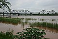
View from the Red River to the Long Biên Bridge

USAF reconnaissance photo of the destroyed bridge in May 1972

A section of the bridge that was destroyed by American bombs

Tracks to Hanoi Railway Station

Part of the steel framework construction
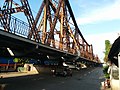
forbidden road below the bridge

Photo of the Long Biên Bridge in 2009

View from the bridge to the sunset over the Red River


Web links and literature
- Naval Intelligence Division: Indo-China, Geographical Handbook Series, BR 510, HMSO, Cambridge 1943
Individual evidence
- ↑ a b c Long-Bien Bridge. structurae .de, accessed on July 10, 2019 .
- ^ Claudine Cartier: Daydé et Pillé à Creil. diaphane.org, 2015, accessed July 10, 2019 (French).
- ↑ Fredrik Logevall: Embers of War: The Fall of an Empire and the Making of America's Vietnam . Random House Publishing Group, 2012, ISBN 978-0-375-75647-4 , pp. 173 (English).
- ↑ Tim Doling: The Long Biên Bridge - “A Misshapen But Essential Component of Hà Nội's Heritage”. saigoneer.com, March 4, 2014, accessed July 9, 2019 .
- ^ Intelligence Information Cable. (PDF) CIA, September 1, 1967, accessed July 10, 2019 (English, published Dec. 2000).
- ^ JICA Vietnam Office: Natural Conditions in the Red River Delta. (PDF) Japan International Cooperation Agency, accessed July 10, 2019 .
- ↑ Team 3G, Đỗ Anh Đức: Những phận người dưới chân cầu Long Biên. spiderum.com, June 4, 2019, accessed July 10, 2019 (Vietnamese).
- ↑ Thái Linh: HN thêm 5 di tích đặc biệt, cầu Long Biên lo bị phá. baodatviet.vn, February 23, 2014, accessed July 12, 2019 (Vietnamese).