
Route Coloniale
Route Coloniale (short RC , German colonial road ) was the name of the trunk roads in French Indochina . These were streets, for the planning, construction and maintenance of which not the individual parts of the country, but the higher-level administration (Office of the Governor General ) was responsible and whose costs were thus paid from the total budget of Indochina.
Outside of Indochina there were Routes Coloniales in the French colonial empire in Guadeloupe , Guyana , Martinique , New Caledonia and Polynesia - albeit much shorter and less important.
Road construction in Indochina
In French Indochina, the construction of national roads did not begin until the First World War. Previously, the colonial authorities planned to handle all long-distance traffic by rail and shipping. In 1913, funds for road construction were approved for the first time. From 1918 onwards, the development of the trunk road network was pushed ahead quickly after the experiences of the World War and technical progress had led to a rethinking of the colonial administration. This realignment of the colonial transport concept was at the expense of the railway, whose network was only expanded slowly from now on, as well as the local shipping companies.

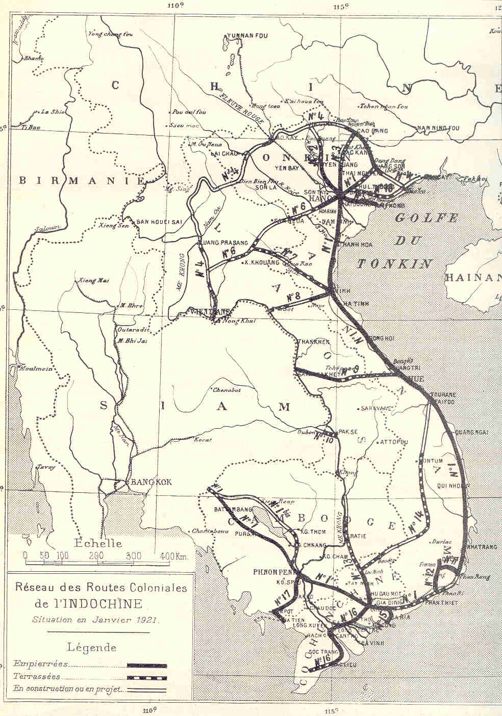
On the eve of World War II, the road network in Indochina was among the best in East and Southeast Asia . Compared to Western Europe, however, the overall development status was poor. Many ambitious connections had never been realized; in particular, there was not a single developed road link in northern Laos and northwestern Vietnam. The quality of the existing routes was also often extremely poor, and during the rainy season many of the roads that had actually been developed were hardly passable. In 1939, Indochina had about 36,000 kilometers of roads, 9,000 kilometers of which were trunk roads classified as Routes coloniales . The other roads, on the other hand, were subordinate to the authorities of the individual parts of the country ( Annam , Cochinchina , Tonkin , Cambodia , Laos ) as routes locales , with the majority of the built road kilometers being concentrated in the metropolitan areas of Hanoi and Saigon .
The well-developed roads were Routes Empierrées , i.e. roads with a macadam-style gravel surface (mostly tar-bound macadam ). From the 1930s, asphalt roads began to appear around the conurbations . In 1939 the proportion of paved highways (macadam and asphalt) was already over 50%. The paved roads were 5 to 6 meters wide in the lowlands and 4 to 4.5 meters in the mountains. Bridges were 2.5 to 3 meters wide and had only one lane. The stone material used for the road subsoil was mainly what was available on site, i.e. limestone in central and southern Tonkin (Greater Hanoi) and laterite in Cochinchina (Saigon). However, since both types of rock were relatively soft and not very weather-resistant, at least the main arteries of the cities were reinforced with imported rock such as granite and quartzite . In some cases, roads in rural Cochinchina were built without a substructure due to a lack of material, i.e. the tar macadam road surface was laid without a stone foundation.
The worse-maintained roads were divided into three categories: Routes terrassées ( " Terraced streets") were dam-like man made roads without pavement sealed and found mainly in the mountains and swamps. Routes non cylindrées were primitive streets covered with coarse, unbroken (crushed) aggregate . Finally, there were also completely unpaved seasonal paths that could only be used during the absolute dry season. Bridges on such roads were usually just the simplest constructions made of wood and bamboo.
The best known Route Coloniale was undoubtedly Route Coloniale 4, which was built along the Chinese border for strategic military reasons . Although it was never fully completed, it was fiercely contested during the Indochina War . The victory of the Việt Minh in the battle of Route Coloniale 4 in autumn 1950 is considered to be the turning point of the war, as from then on the French fell on the defensive.
After the independence of Vietnam , Cambodia and Laos , the colonial roads became the national roads of the three countries. While the French numbering has largely been adopted to this day in Vietnam and Laos, the highways in Cambodia have been renumbered.
List of Routes Coloniales
| number | Course ( planned ) | today's national roads |
|---|---|---|
| RC 1 ( Route Mandarine ) |
Poipet - Sisophon - Battambang - Phnom Penh - Saïgon - Phan Thiết - Phan Rang - Quy Nhơn - Quảng Ngãi - Tourane - Huế - Đông Hà - Vinh - Thanh Hóa - Hanoï - Bắc Ninh - Lạng Sơn |
|
| RC 1 to | Sisophon - Siem Reap - Phnom Penh |
|
| RC 2 | Hanoï - Tuyên Quang - Hà Giang |
|
| RC 3 | Hanoï - Thái Nguyên - Cao Bằng |
|
| RC 4 | Móng Cái - Lạng Sơn - Cao Bằng ( - Hà Giang ) - Lào Cai - Sa Pa ( - Lai Châu - Điện Biên Phủ - Luang Prabang ) |
|
| RC 5 | Hanoï - Hải Dương - Hải Phong |
|
| RC 6 | Hanoï - Hòa Bình - Sam Neua ( - Luang Prabang ) |
|
| RC 7 ( Route de la Reine Astrid ) |
Vinh - Phonsavan - Luang Prabang |
|
| RC 8 | Vinh - Vieng Kham - Thakhek |
|
| RC 9 | Đông Hà - Savannakhet |
|
| RC 10 | Paksé - Chong Mek |
|
| RC 11 | Phan Rang - Dalat |
|
| RC 12 | Phan Thiết - Dalat |
|
| RC 13 (Route René Robin ) |
Saïgon - Chơn Thành - Kratie - Stung Treng - Paksé - Savannakhet - Thakhek - Vientiane - Luang Prabang |
|
| RC 14 | Chơn Thành - Đồng Xoài - Gia Nghĩa - Buôn Ma Thuột - Pleiku - Kon Tum - Tourane |
|
| RC 15 | Biên Hòa - Bà Rịa - Cap Saint-Jacques |
|
| RC 16 | Saïgon - Mỹ Tho - Vĩnh Long - Cần Thơ - Bạc Liêu |
|
| RC 17 | Phnom Penh - Kampot - Kep - Hà Tiên |
|
| RC 18 | Bắc Ninh - Hạ Long - Móng Cái |
|
| RC 19 | Quy Nhơn - An Khê - Pleiku |
|
| RC 20 | Saïgon - Bảo Lộc - Dalat |
|
| RC 21 | Sơn Tây - Nam Định |
|
| RC 22 | Saïgon - Tây Ninh - Kampong Cham |
|
| RC 23 | Muang Phin - Saravan |
|
Web links
- WikiSara: List of routes coloniales en Indochine française
- University of Texas at Austin - University of Texas Libraries: Indochina and Thailand 1: 250,000, Series L509, US Army Map Service, 1954– (detailed maps for Indochina)
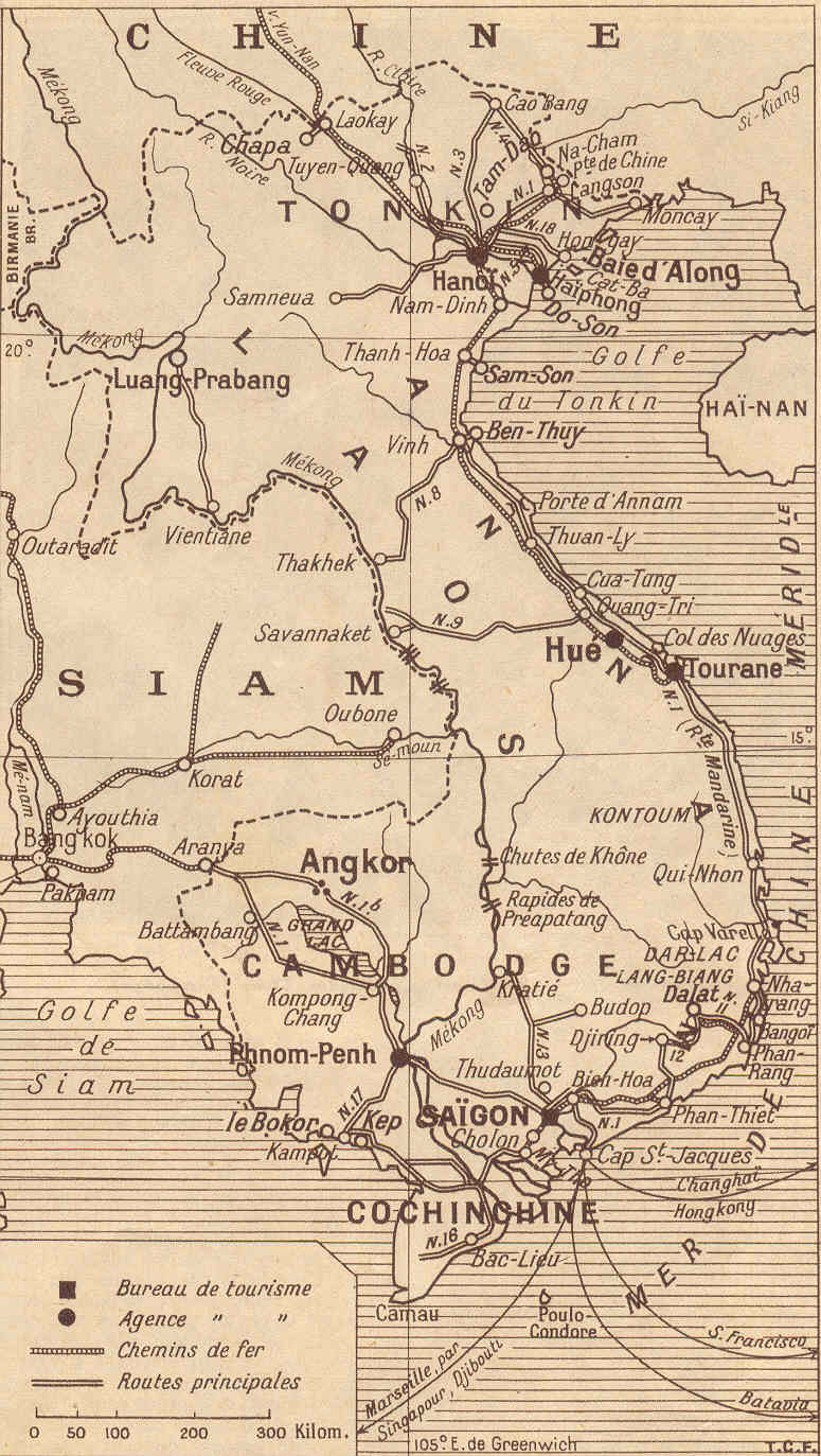
- belleindochine.free.fr - Plans et cartes : Réseau des Routes Coloniales de l'Indochine , from: La Vie technique, industrial, agricole et coloniale, 1922 ; Carte de Tourisme, Touring Club, 1931
Footnotes
- ↑ Stéphanie Ponsavady: Cultural and Literary Representations of the Automobile in French Indochina: A Colonial Roadshow , Palgrave Macmillan / Springer, 2018, p. 206
- ↑ WikiSara: List of routes coloniales françaises (accessed February 2019)
- ^ Naval Intelligence Division : Indo-China , Geographical Handbook Series, BR 510, HMSO, Cambridge 1943, pp. 409/410
- ↑ Route Mandarine refers to the section from Hanoi to Saigon, which was built by the Vietnamese emperors before the French conquest. Cf. for example Naval Intelligence Division: Indo-China , Geographical Handbook Series, BR 510, HMSO, Cambridge 1943, p. 412
- ↑ The Route de la Reine Astrid was named after Queen Astrid of Belgium , who together with her husband Leopold III. Visited Indochina during construction and had a fatal accident a little later. Cf. Karl Gustav Izikowitz: Over the Misty Mountain: A Journey from Tonkin to the Lamet in Laos , White Lotus, Bangkok 2004, p. 6
- ^ Naval Intelligence Division: Indo-China , Geographical Handbook Series, BR 510, HMSO, Cambridge 1943, p. 416
- ^ Bernard B. Fall : Street Without Joy , Stackpole Books, Harrisburg 1994, p. 199. See also: Battle of the Mang-Yang Pass .
- ↑ Gerald Cannon Hickey: Shattered world: adaptation and survival among Vietnam's highland peoples during the Vietnam War , University of Pennsylvania Press, 1993, p. 51
- ↑ David G. Marr: Creating Defense Capacity in Vietnam, 1945-1947 . In: Mark Atwood Lawrence, Fredrik Logevall: The First Vietnam War: Colonial Conflict and Cold War Crisis , Harvard University Press, 2007, pp. 81/82
- ↑ René Morizon: Journal du Cambodge , Imprimerie d_Extreme-Orient, 1931, S. 236, 245th
- ↑ Pierre Gentil: Sursauts de l'Asie: Remous you Mékong , 1950 ( "Nous voyons le pont de la route coloniale 23, joignant Muong Phin à Saravan." )