
Luang Prabang
|
ຫຼວງ ພະ ບາງ Luang Prabang |
|||
|---|---|---|---|
|
|||
| Coordinates | 19 ° 54 ' N , 102 ° 8' E | ||
| Basic data | |||
| Country | Laos | ||
| Luang Prabang | |||
| ISO 3166-2 | LA-LP | ||
| height | 300 m | ||
| Residents | 66,781 (2015) | ||
 Luang Prabang from Mount Phou Si
|
|||

Luang Prabang (also Luang Phrabang or Louangphrabang ; Lao : ຫຼວງ ພະ ບາງ , ALA-LC : Lūang Phabāng , pronunciation: [ lúaŋ.pʰā.bǎːŋ ]; in ancient times called Chieng Dong Chieng Thong , Müang Sua or Sawa ) is the capital of Luang Province Prabang in the mountainous north of Laos . The population is 66,781 (as of 2015). Luang Prabang was the capital of the historic Lan Xang Kingdom and the French Protectorate of Laos. Until the abolition of the monarchy in Laos in 1975, it was the royal city. Today the city is recognized by UNESCO as a World Heritage Site and is one of the main tourist destinations in the country.
Location and importance

The historic center of the city is protected by the spur between the Mekong and its tributary Nam Khan at an altitude of around 300 meters. It is a trading center for rice , rubber and teak . Handicraft products such as woodwork, textiles and paper are also produced. Luang Prabang is the seat of a university, the Souphanouvong University.
The city is connected to Vientiane via Vang Vieng via the asphalt national road 13 . An extension of the NH-13 to the Lao-Chinese border does not lead through Luang Prabang, but via a bypass around the city. Luang Prabang will nevertheless benefit considerably from the impetus to be expected from trade with China.
Airport
Luang Prabang has an international airport about three kilometers northeast of the city , which is served by Vientiane , Bangkok and Siem Reap , among others , and frequented mainly by tourists. There is also a connection to Hanoi and Kunming as well as Chiang Rai .
climate
| Luangphrabang | ||||||||||||||||||||||||||||||||||||||||||||||||
|---|---|---|---|---|---|---|---|---|---|---|---|---|---|---|---|---|---|---|---|---|---|---|---|---|---|---|---|---|---|---|---|---|---|---|---|---|---|---|---|---|---|---|---|---|---|---|---|---|
| Climate diagram | ||||||||||||||||||||||||||||||||||||||||||||||||
| ||||||||||||||||||||||||||||||||||||||||||||||||
|
Monthly average temperatures and rainfall for Luangphrabang
|
|||||||||||||||||||||||||||||||||||||||||||||||||||||||||||||||||||||||||||||||||||||||||||||||||||||||||
history

The history of the city of Luang Prabang is inextricably linked with the history of Laos. The political decline of the Sukhothai Kingdom in northern Thailand in 1345 and the relocation of the political center in Siam to Ayutthaya in 1351 also accelerated the need for a political unification process east of the Mekong. 1365 is commonly referred to as the founding year of Lan Xang ("Land of Millions of Elephants") under Fa Ngum . As a vassal of the Khmer Empire, Fa Ngum had received the Buddha statue Phra Bang as a coronation gift from Angkor. This was venerated in Luang Prabang, which was the capital of the Kingdom of Lan Xang between 1354 and 1560, as a holy statue with the function of legitimizing power. Around 1356 Luang Prabang became a place of pilgrimage for the Phra Bang Buddha statue.
Many Buddhist monasteries were built in Luang Prabang in the 16th century under King Setthatirat . In the course of the Buddhist missionary work, Wat Pasman was built on the site of today's Wat That Luang as the oldest sacred building in the city. The relocation of the capital to Vientiane, which King Setthathirath had arranged for in 1560 for fear of attacks from Burma , meant a considerable loss of power for Luang Prabang . Nevertheless, Luang Prabang remained the country's cultural center. For three centuries Luang Prabang was henceforth a pawn in the struggle between the Thai and the Burmese for political supremacy between Irrawaddy and Mekong , as a result of which the city was repeatedly destroyed. In 1700, Laos was finally divided into three parts: Luang Prabang, Vientiane and Champasak .
French colonial period from 1893 to 1953
First reports of Luang Prabang by Henri Mouhot in 1861, Louis Delaporte in 1867 and Auguste Pavie in 1886 reached Europe in the middle of the 19th century. Laos came under the crosshairs of the power political rivalry between France and England. France hoped to travel up the Mekong to reach southern China, but the Mekong turned out to be not consistently navigable. Nevertheless, the French were interested in political control of Laos as a strategic safeguard for their colony of Vietnam . With clever tactics, France took advantage of the distress in which the Laotians found themselves in view of the attacks by Chinese gangs in 1887, and declared the region of Luang Prabang to be the protectorate of their colony Union Indochinoise (1893–1954). However, in contrast to Vietnam, Laos was not of economic importance for France. Until the middle of the 20th century, Laos, and with it Luang Prabang, was strongly influenced by the cultural and architectural influences of the colonial power France. Even before France's devastating defeat at Điện Biên Phủ in 1954, Laos was granted political independence in 1953.
Indochina War from 1962 to 1975
Despite the International Laos Conference in Geneva in 1962, at which the country was granted neutrality, military supplies for the Viet Cong in South Vietnam took place on the Ho Chi Minh Trail through Laotian territory during the Indochina War . Heavy bombing by the US Air Force was the result. The city of Luang Prabang was largely spared from the fighting, although units of the communist Pathet Lao organization had holed up north of the city in the area of the Pak-Ou caves. In 1975 communist units conquered the city.
Development since 1975
The last Laotian king Sisavang Vatthana , who resided in Luang Prabang until 1975, was deported to a political re-education camp with his wife and the crown prince. The royal family was killed there - probably in 1984 - from previously unexplained circumstances. When the Pathet Lao came to power, there was also an exodus of anti-regime Laotians in Luang Prabang; around 300,000 people across the country fled. The city of Luang Prabang fell into a “Sleeping Beauty Sleep”.
Since the economic liberalization, especially the privatization of tourism in 1991, the cultural and historical importance of Luang Prabang has been recognized and increasingly marketed. 1995 Luang Prabang became the UNESCO - World Heritage declared. 32 Buddhist monasteries as well as the entire French colonial architecture in the city were placed under monument protection and have been restored since then. Restrictive urban planning should also prevent violations of the art-historically unique character of the city center. In 2015, 500,000 foreign tourists visited Luang Prabang.
| Town of Luang Prabang | |
|---|---|
|
UNESCO world heritage |
|
| National territory: | Laos |
| Type: | Culture |
| Criteria : | (ii) (iv) (v) |
| Surface: | 820 ha |
| Buffer zone: | 12560 ha |
| Reference No .: | 479 |
| UNESCO region : | Asia and Pacific |
| History of enrollment | |
| Enrollment: | 1995 (session 19) |
| Extension: | 2013 |
Attractions
Luang Prabang City


.jpg)
- Royal Palace (Ho Kham), now the National Museum - to be visited among other things: throne of the rulers of the Lan Xang period, religious treasures. Erected between 1904 and 1909.
- Vat Xienthong (also Wat Xieng Thong) - temple complex on the Mekong, which was built under King Setthathirath in 1560 and restored between 1960 and 1962. As the only temple in the city, it survived the sacking of 1887 unscathed. The architectural style with the roof reaching almost to the ground is typical for northern Laos.
- Vat Visounarath (also Wat Visoun, Wat Visounarath) is a temple complex on the southeast side of the Phousi Mountain. King Visounarath founded the monastery in 1512, which was destroyed by Chinese hordes in 1887. Most of the complex was rebuilt in the 20th century. The Sim (Laotian name for the main building of a wat ) from 1898 contains window pillars in the Khmer style. Inside there has been a museum since 1942 with numerous Buddha statues, especially in the rain call gesture typical of Luang Prabang (standing with overlong arms pointing downwards parallel to the body).
- That Makmo (watermelon stupa ), located on the grounds of Vat Visounarath. The name is derived from its semicircular tip. Donated by Phantin Xieng, wife of King Visounarath, in 1504, the stupa was rebuilt in 1932, with the precious gifts being transferred to the royal palace.
- Vat Sop: The temple complex is located in the northeast of the old town and was founded in 1480 as the burial temple of King Chakkrapat. In 1485, a second burial temple was built on the property, which was combined with the first one built during renovations in the 18th century. The current buildings, next to which a widely visible Frangipani rises, were built in 1909. Behind the Vat Sop on the street called Thanon Vat Sop is a typical residential area, called Baan in Lao , in which one cannot yet get an impression of the tourism impaired everyday life of the locals.
- Vat Chom Kong (also Vat Choum Khong): This temple, built around 1850, is known, among other things, for its garden, which is said to be one of the most beautiful in the city, and for the two guardian figures in front of the main building from China.
- Mount Phousi (130 meters high, 328 steps), topographical accent and spiritual center opposite the Royal Palace with a view of the entire city area, the Mekong and the wooded mountain landscape of the area.
- Night market at the foot of Phousi Mountain: in Thanon Sisavangvong, the main street of the old town, hand-made textiles, souvenirs and food are offered every evening (approx. 6 to 10 p.m.) between the Royal Palace and the cross street Thanon Setthathirat. Many of the traders belong to the Hmong people , who are known for their high quality weaving, embroidery and sewing work.
- Phimai (New Year) Festival in April - one of the most impressive Buddhist festivals in mainland Southeast Asia.
Outside of Luang Prabang
- The Pak Ou limestone caves - right on the cliffs of the Mekong, about 25 kilometers north of Luang Prabang, are one of the most important Buddhist pilgrimage sites in Laos. These are two cave temples that are located at the mouth of the Nam Ou in the Mekong and can only be reached by boat after an hour and a half drive. Here, during the Indochina War, private Buddha statues were brought to safety for the population from looting. At times, over 5000 statues are said to have stood in the two cave temples. Hundreds of them, of various sizes, can still be seen in the two caves, they were also brought here as offerings by pilgrims. According to legend, the two caves have been used as temples since 1547. The entire complex is also called Tham Ting ("Ting Cave"). In the lower cave, Tham Loum , there are numerous Buddha statues up to one meter in size made of wood, bronze, iron or clay and a water point for ritual cleaning of the statues. To get to the upper and deeper cave, Tham Theung , you have to climb another bit. Hermit monks lived at times in this darker of the two caves.
- Kuang Si Waterfall - about 45 minutes from Luang Prabang.
- Tad Sae Waterfall - the smaller and closer waterfall in the area. Ideal for swimming and a short walk through the jungle.
- The tomb of Henri Mouhot is east of the city, four kilometers past Ban Phanom, to the left of the path on the banks of the Nam Khan. Mouhot died in Luang Prabang in 1861 as a result of malaria. The gravestone, which was only rediscovered in the jungle in 1990, had the French consul Auguste Pavie erected in 1887 .
- On the opposite bank of Luang Prabang, about a 15-minute boat ride away, is the Pha Tad Ke Botanical Garden, which opened in 2016 .
- Also on the opposite bank, which can only be reached by ferry or boat, are the temples Wat Chom Pet, Wat Xieng Maen and Wat Tham Sakkalin, which are little visited by tourists.
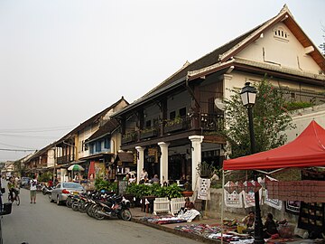
Thanon Sisavangvong, one of the main streets of the old city

Vat Chom Kong temple complex in the old town

Pak Ou Cave - view from the Mekong

Kuang Si waterfall

Sunset on the Mekong from Wat Phra Bat Tai


.jpg)

Daughters and sons of the city
- Khun Phi Fa († 1343), king of Rajadharani Sri Sudhana
- Fa Ngum (1316–1393), first king of Lan Xang
- Suvanna Ban Lang (1455–1485), King of Lan Xang
- Pho Thisarath I (1505– ~ 1548), King of Lan Xang
- Pho Thisarath II (1552–1627), King of Lan Xang
- Sulinyavongsa (* 1618), king of Lan Xang
- Kingkitsarat († 1713), King of Luang Phrabang
- Anurut (1737–1819), king of Luang Phrabang
- Manthatulat (1772–1837), King of Luang Phrabang
- Sukaseum (1797–1850), king of Luang Phrabang
- Tiantha (~ 1797–1870), king of Luang Phrabang
- Oun Kham (1811–1895), King of Luang Phrabang
- Sakkalin (1840–1904), king of Luang Phrabang
- Sisavang Vong (1885–1959), King of Laos (1904–1959)
- Phetsarath (1890-1959), politician
- Khammao Vilai (1892-1965), politician, Prime Minister of the first free Lao government (1945-1949)
- Souvanna Phouma (1901–1984), politician, Prime Minister of Laos (1951–1954, 1956–1958, 1960 and 1962–1975)
- Savang Vatthana (1907– ~ 1978), ruler, last Laotian king (1959–1975)
- Souphanouvong (1909–1995), politician
- Ouane Rattikone (1912–1978), General of the Lao Air Force and drug dealer
- Somsanith Vongkotrattana (1913–1975), politician; Prime Minister of Laos (1960)
literature
- Hans Georg Berger: Het Bun Dai Bun - Laos, Sacred Rituals of Luang Prabang. 2000. ISBN 1-903391-02-4 .
- Francis Engelmann and T. Renault: Luang Prabang - Capitals of Legends Series. Paris 1997. ISBN 2-911589-15-7 .
- Betty Gosling: Old Luang Prabang. Singapore: Oxford 1996. ISBN 983-56-0006-6 .
- Götz Hagmüller and Elisabet Lind: Cultural Institutions in Laos: The Royal Palace of Luang Prabang - General Condition, Conservation and Restoration Needs. Vol. 2, NIAS Reports, 1994. ISBN 87-87062-41-0 .
- Denise Heywood: Ancient Luang Prabang . Bangkok: River Books Press 2006.
- H. Rattanavong et al .: Treasures of Luang Prabang . Vientiane: Institute of Cultural Research 2000.
- Phia Sing: Traditional Recipes of Laos. 124 Authentic and Traditional recipes from the Royal Palace of Luang Prabang . Bangkok 2000.
- UNESCO (ed.): Tourism and Heritage Site Management - Luang Prabang, Lao PDR . Bangkok 2004.
- Charles FB Wilding-White: Luang Prabang and its Temples . Arts of Asia (Bangkok), 6 (1976) 1: 50-59.
Web links
- Tourism and Heritage Site Management - Luang Prabang, Lao PDR. UNESCO, Bangkok 2004 (PDF; 4.02 MB)
- Francis Engelmann: Luang Prabang: A Ghost Town Returns to Life. ( Memento of April 20, 2007 in the Internet Archive ) - UNESCO-Courier, 1999 (Internet Archives)
- Through yesterday's Asia - travel report. Die Welt, December 31, 2005
- Treasures of the world: Luang Prabang. Old royal city on the Mekong. SWR
- Entry on the UNESCO World Heritage Center website ( English and French ).
Individual evidence
- ↑ UNESCO World Heritage Center: Town of Luang Prabang. Retrieved August 9, 2017 .
- ↑ Tourist Arrivals to Luang Prabang Increase by 16% Annually. Retrieved November 11, 2017 (American English).

Cultural heritage: Luang Prabang with the royal palace and Buddhist monasteries (1995) | Wat Phou Temple District and Champasak Cultural Landscape (2001)