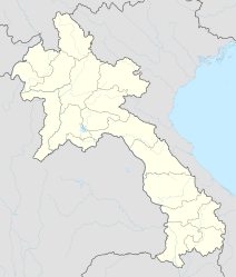
Vang Vieng
|
ວັງ ວຽງ Vang Vieng |
||
|---|---|---|
|
|
||
| Coordinates | 18 ° 56 ' N , 102 ° 27' E | |
| Basic data | ||
| Country | Laos | |
| Vientiane | ||
| ISO 3166-2 | LA-VI | |
| Residents | 25,000 (2005) | |
|
Street in Vang Vieng
|
||
Vang Vieng ( Lao : ວັງ ວຽງ ; also Vang Viang ) is a small town in the province of Vientiane in Laos . The city is surrounded by karst formation and monsoon forest . The population is around 25,000 (as of 2005).
Location and traffic
International airports are located in Luang Prabang or Vientiane. Vang Vieng can be easily reached by bus from both locations. National Road 13, one of the few paved roads in the country, is in good condition. It is about 230 km to Luang Prabang, the drive takes about six hours due to the mountainous landscape. Vientiane is around 160 km away, which is around three to four hours. The buses depart from a former American runway in the east of the city that dates back to the time of the Vietnam War .
tourism
The city is located on the Nam Xong River (also Nam Song) between Vientiane and Luang Prabang . Vang Vieng has numerous accommodations and restaurants along a few streets. It is suitable as a stopover on the way to Luang Prabang. The numerous caves in the area and the impressive landscape attract many visitors. Since the beginning of the 1990s tourism was privatized, the number of travelers has increased steadily.
Vang Vieng is known among backpackers as a scene for exuberant parties with drugs (mainly alcohol) and music. According to official figures, 22 holidaymakers died in 2011, many of them when they drove down the river with inflated car tubes and overturned on rapids. There were six accidental deaths by mid-2012. In response, the Lao authorities closed 24 bars in August 2012.
Attractions
city
There are four smaller Buddhist temples ( Wat )
- Wat Si Vieng Song
- Wat Kang
- Wat Si Suman
- Wat Si Mixayaham
At the place on the river bank is a small island with several bars, accessible via a jetty in the dry season from October to June.
Surroundings
In the mountainous surroundings you can do active sports, the landscape is ideal for rafting , kayaking and climbing . You can also swim in many caves or at waterfalls. These can be reached by rental bike or tuk-tuk .
Here are just a few examples of the innumerable caves (Tham):
- Tham Pha Jao (with Buddha)
- Tham Phu Kham (Thai Bronze Buddha)
- Tham Jang ( used as a bunker in the 19th century , river source with very strong current - bathing possible)
- Python Cave (so called because it winds its way into the mountain like a long hose; it was only discovered in the mid-1990s)
Web links
- Denis D. Gray: Ghosts, opium and backpackers on Laotian mountain road. The Daily Courier, March 12, 2000
- Abigail Haworth: Vang Vieng, Laos: the world's most unlikely party town. The Guardian, April 7, 2012
Individual evidence
- ↑ Report on nzherald.co.nz of September 22, 2009 , accessed on August 19, 2012
- ↑ The Party Flow of Death. Tagesanzeiger (Zurich), July 3, 2012, accessed on August 19, 2012
- ↑ The deadly tourist attraction in Laos. Tagesanzeiger (Zurich), July 4, 2012, accessed on August 19, 2012
- ↑ Laotian authorities shut down the traveler paradise Vang Vieng. Southeast Asia 4, 2012


