Vientiane Province
| ແຂວງ ວຽງ ຈັນ Vientiane
|
|
|---|---|
| Basic data | |
| Country | Laos |
| Capital | Muang Phôn-Hông |
| surface | 15,927 km² |
| Residents | 419,090 (2015) |
| density | 26 inhabitants per km² |
| ISO 3166-2 | LA-VI |
Coordinates: 18 ° 48 ' N , 102 ° 12' E
Vientiane ( Laotian ແຂວງ ວຽງ ຈັນ , ALA-LC : Khwǣng Vīang Chan ) is a province ( Khwaeng ) in central Laos . The capital of the province is Muang Phôn-Hông .
geography
The province of Vientiane is located in the northwest of the country. The neighboring provinces are (clockwise from southwest): Sainyabuli , Luang Prabang , Xieng Khouang , Saysomboun, and Vientiane Prefecture .
To the southeast, the Mekong forms the border with Thailand . On the opposite bank lies the Thai province of Nong Khai .
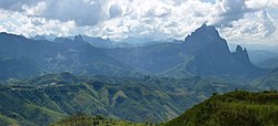
In the east of the province is Mount Phu Bia , at 2850 meters the highest point in Laos and the highest peak of the Truong Son Mountains . In the center of the province lies the 370 km² Nam Ngum reservoir, which is dammed by a dam on the Nam Ngum River. Parts of the province are designated as National Biodiversity Protected Areas: Phou Khao Khouay and Phou Phanang , both in the south of the province.
history
In 1989 the province was split into two parts, the prefecture of Vientiane, which included the capital Vientiane , and the rest of the area, the province of Vientiane.
When the Xaysomboun Special Zone was dissolved, Hom district was added to the province in 2004 and Xaysomboun district in 2006. Saysomboun was rebuilt as a province in 2013.
Administrative division
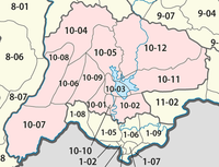
The province consists of the following eleven districts ( ເມືອງ - [ mʉ̄aṅ ]):


