Luang Namtha Province
| ແຂວງ ຫຼວງ ນໍ້າ ທາ Luang Namtha
|
|
|---|---|
| Basic data | |
| Country | Laos |
| Capital | Luang Namtha |
| surface | 9325 km² |
| Residents | 175,753 (2015 census) |
| density | 19 inhabitants per km² |
| ISO 3166-2 | LA-LM |
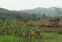
| On the road from Luang Namtha to Luang Prabang | |
Coordinates: 21 ° 0 ′ N , 101 ° 24 ′ E
Luang Namtha ( Lao ແຂວງ ຫຼວງ ນໍ້າ ທາ , Khwaeng Luang Namtha ), also Louang Namtha , is a province in northern Laos .
From 1966 to 1976 she formed the Houakhong Province together with Bokeo . The majority of the population in the province are not Lao or related Tai peoples , but belong to ethnic groups known as Lao Soung ("highland Laotians") or Lao Theung ("mountain slope Laotians").
geography
The province is bordered by the Bokeo Province to the southwest, the Oudomxay Province to the southeast , the Shan State of Myanmar to the northwest , and the Xishuangbanna Autonomous District of the Chinese Yunnan Province to the northeast . There is a border crossing to China in Boten .
The Mekong forms the border in the northwest, three large rivers flow west and south and then flow into the Mekong: the Nam Tha , the Nam Fa and the Nam Long .
One of the most beautiful and spectacular pristine monsoon forests of Laos is located in Luang Namtha. This is partially protected by the Nam Ha National Biodiversity Conservation Area , which makes up a large part of the area of the very sparsely populated province. The protected area was created for ecotourists with the help of neighboring and western countries as well as international organizations.
traffic
The province of Luang Namtha is crossed by National Road 3 and National Road 13 . National Road 13 leads to the border in Boten , which enables a connection via the city of Mohan to southern China. Trucks coming from China then load their supposedly mostly smuggled goods into boats in Xien Kok, which then transport them further south across the Mekong.
Lao Airlines connects Luang Namtha Airport (IATA code LXG) with the capital Vientiane three times a week .
Administrative units
The province consists of the following districts (muang) :
| code | District | Lao |

|
|---|---|---|---|
| 03-01 | Namtha | ນໍ້າ ທາ | |
| 03-02 | Sing | ສິງ | |
| 03-03 | Long | ລອງ | |
| 03-04 | Viangphoukha (Viengphoukha) | ວຽງ ພູ ຄາ | |
| 03-05 | Nale (Nalae) | ນາ ແລ |
literature
- Nathan Badenoch, Tomita Shinsuke: Mountain People in the Muang. Creation and Governance of a Tai Polity in Northern Laos. (PDF; 1.1 MB) In: Southeast Asian Studies , Volume 2, No. 1, April 2013, pp. 29–67.
Web links
- Attractions of Louang Namtha (in English)
- Map of Louang Namtha Province
- Tourism as a Tool for Development - Nam Ha Ecotourism Project (in English; PDF; 515 kB)
Individual evidence
- ^ Badenoch, Tomita (2013), p. 29.
- ↑ Lonely Planet Laos. German edition, 2008, p. 223.
- ^ An Uncertain Future: Biodiversity and livelihoods along the Mekong River. The World Conservation Union (IUCN), Bangkok / Gland 2008, p. 28.
- ↑ Archived copy ( memento of the original from October 18, 2009 in the Internet Archive ) Info: The archive link was inserted automatically and has not yet been checked. Please check the original and archive link according to the instructions and then remove this notice.


